Community Corner
WEATHER UPDATE: Snow and Ice Accumulation Prediction Made for Greenwich
The National Weather Service has issued a Winter Weather Advisory for the area beginning at midnight.

By Brian McCready and Barbara Heins (Patch Staff)
The National Weather Service is predicting there will be precipitation falling for the next 18 hours or so and all we’re expecting to receive is an accumulation of 1-3 inches of snow, and a quarter inch of ice accumulation.
The National Weather Service has posted a Winter Weather Advisory for the area and states in its bulletin, that a light mix precipitation will develop today and grow steader this evening and continue into Monday morning before ending late Monday.
Find out what's happening in Greenwichfor free with the latest updates from Patch.
This appears to be more of a nuisance storm as the ice accumulation will clearly be the biggest threat. It also will be interesting to see whether the weather impacts local school operations. Greenwich Public Schools are closed this week for mid-winter break, however, most Greenwich private schools have classes scheduled for Monday and Tuesday.
__________________________
Find out what's happening in Greenwichfor free with the latest updates from Patch.
Sign up for Greenwich Patch news alerts to stay on top of the latest weather developments by clicking here.
___________________________
Here is Greenwich’s latest hyperlocal weather forecast from the National Weather Service:
- Today: A slight chance of rain and snow before 3 p.m., then a chance of rain and sleet. Cloudy, with a high near 36. Wind chill values between 25 and 30. East wind around 8 mph. Chance of precipitation is 40%.
- Tonight: Snow and freezing rain, mainly after 9pm. Low around 26. Wind chill values between 20 and 25. Northeast wind 7 to 10 mph. Chance of precipitation is 90%. New ice accumulation of less than a 0.1 of an inch possible. New snow accumulation of less than a half inch possible.
- Monday: Snow, freezing rain, and sleet before 3pm, then snow and freezing rain. High near 30. Wind chill values between 15 and 20. Northeast wind around 13 mph. Chance of precipitation is 100%. New ice accumulation of 0.1 to 0.2 of an inch possible. New snow and sleet accumulation of less than a half inch possible.
- Monday Night: Snow and freezing rain before 3am, then a slight chance of snow. Low around 25. Wind chill values between 15 and 20. North wind around 15 mph. Chance of precipitation is 90%. New ice accumulation of less than a 0.1 of an inch possible. New snow accumulation of less than a half inch possible.
- Tuesday: Partly sunny, with a high near 35. North wind around 14 mph.
- Tuesday Night: Mostly clear, with a low around 15.
- Wednesday: Mostly sunny, with a high near 32.
- Wednesday Night: Mostly cloudy, with a low around 22.
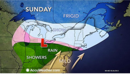
Photo credit: accuweather.com
Get more local news delivered straight to your inbox. Sign up for free Patch newsletters and alerts.