Weather
Risk Of 'Life-Threatening' Surge As Tropical Storm Debby Approaches FL
Tropical Storm Debby drew new warnings and could reach hurricane strength before landfall; the Big Bend area is under a hurricane warning.

Updated at 11:30 p.m. Saturday.
TAMPA, FL — A tropical depression strengthened into Tropical Storm Debby as it moved through the Gulf of Mexico, and forecasters said it could become a hurricane by the time it makes landfall in Florida on Monday.
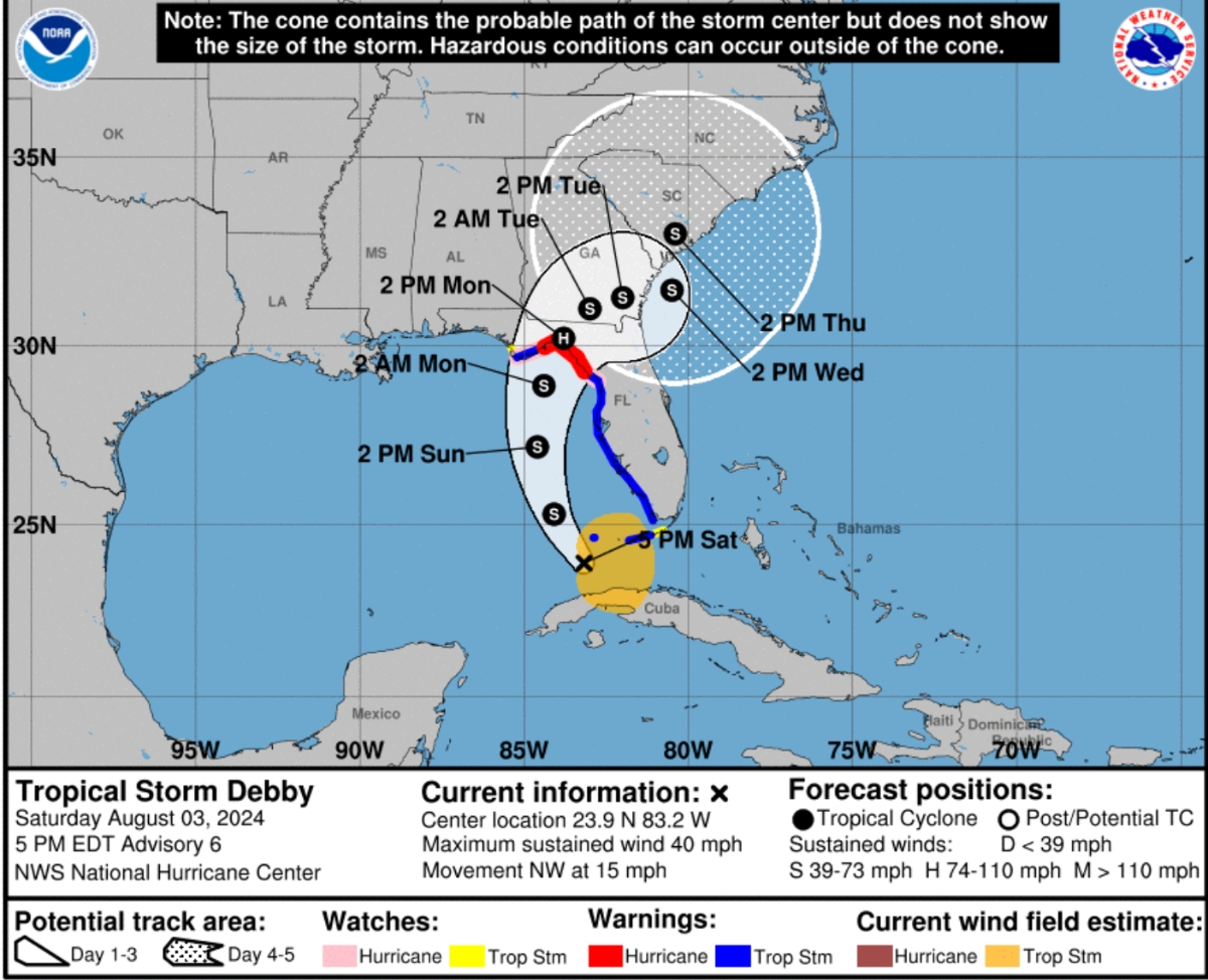
Debby is predicted to bring heavy rain to Tampa Bay and life-threatening storm surge to the Big Bend area as it continues to gain strength, according to the National Hurricane Center.
Find out what's happening in Tampafor free with the latest updates from Patch.
As of 11:30 p.m. Saturday, the storm was located about 50 miles west-southwest of the Dry Tortugas, and about 260 miles south-southwest of Tampa, with maximum sustained winds of 45 miles per hour. Debby was moving toward the northwest at 14 miles per hour, the NHC said.
Also as of the latest update Saturday night, a tropical storm warning was in effect for the west coast of the Florida peninsula from south of the Suwannee River to East Cape Sable, as well as the Florida Keys west of the Seven Mile Bridge including the Dry Tortugas.
Find out what's happening in Tampafor free with the latest updates from Patch.
A hurricane warning was also issued for Florida's Big Bend region from the Suwannee River to the Ochlockonee River, according to the NHC. A hurricane watch is also in place for the coast west of the Ochlockonee River to Indian Pass, and east of the Suwannee River to Yankeetown.
The Tampa Bay area should feel the worst of the storm's effects by 2 p.m. Monday, according to NHC graphics.
While most experts anticipate Debby making landfall as a tropical storm, National Hurricane Center forecasters predict the system will be at or near hurricane strength when it makes landfall in Florida's Big Bend region.
"Strengthening is expected as Debby crosses the Gulf of Mexico, and the system is likely to be at or near hurricane strength when it reaches the Florida Gulf coast," the NHC said in its latest forecast.
According to the NHC, Debby was forecast to move over western Cuba on Saturday morning before moving into the eastern Gulf of Mexico later Saturday and Sunday. Debby is expected to reach the Florida Gulf Coast late Sunday or Monday, forecasters said.
The system is likely to bring heavy rainfall to coastal cities and could cause considerable flash and urban flooding, according to the NHC. River flooding is also expected
Life-threatening storm surge is possible west of the Aucilla River to Indian Pass and south of Aripeka to Bonita Beach, including Tampa Bay and Charlotte Harbor. Tampa Bay could see 2-4 feet of storm surge in prone areas, according to the NWS.
"If you live in flood-prone areas, use today to get ready for the potential of minor storm surge or freshwater flooding," meteorologist Denis Phillips wrote on Facebook. "The storm surge threat continues for Sunday afternoon and evening."
"Rainfall will be 2" inland and up to 8" along the coast," Phillips added. "Rain will continue through Monday as Debby will slow down after landfall. It wouldn't shock me one bit if some areas see more than a foot of rain."
The metro could see 4 to 8 inches of rain and peak winds of 20 to 30 mph with gusts up to 50 mph, staying below tropical storm force.
Hurricane conditions are possible late Sunday in portions of the Florida Gulf Coast and Big Bend region where a hurricane watch is in effect. The Big Bend area suffered heavy damage last year from Hurricane Idalia.
Tropical storm conditions are expected farther south along Florida’s west coast, including the Tampa Bay area.
"There is a danger of life-threatening storm surge inundation along portions of the west coast of Florida from Aripeka to the Aucilla River. Life-threatening storm surge is possible west of Aucilla River to Indian Pass and south of Aripeka to Bonita Beach, including Tampa Bay and Charlotte Harbor," the NHC said.
Debby is the fourth named storm of the 2024 Atlantic hurricane season — following Tropical Storm Alberto, Hurricane Beryl and Tropical Storm Chris, all of which formed in June.
Related:
- Sandbags Available In Bradenton Area As Tropical System Approaches FL
- Sandbags Available Across Tampa Bay As Tropical System Approaches FL
The National Hurricane Center defines the type of weather disturbance by the strength of its wind speed. A tropical depression is a storm with a wind speed of 38 mph.
A tropical storm has wind speeds of 39 to 73 mph.
A hurricane is a storm with sustained wind speed of at least 74 miles per hour.
Gov. Ron DeSantis previously issued a state of emergency for numerous counties, including the Tampa Bay area.
The counties under the state of emergency are Alachua, Baker, Bay, Bradford, Calhoun, Charlotte, Citrus, Clay, Collier, Columbia, Dixie, Duval, Escambia, Flagler, Franklin, Gadsden, Gilchrist, Gulf, Hamilton, Hernando, Hillsborough, Holmes, Jackson, Jefferson, Lafayette, Lake, Lee, Leon, Levy, Liberty, Madison, Manatee, Marion, Monroe, Nassau, Okaloosa, Orange, Osceola, Pasco, Pinellas, Polk, Putnam, Santa Rosa, Sarasota, Seminole, St. Johns, Sumter, Suwannee, Taylor, Union, Volusia, Wakulla, Walton and Washington.
Some parts of Florida could see at least 12 inches of rainfall over the next seven days which could also cause river and coastal flooding, according to the governor’s state of emergency. Widespread power outages should also be expected because of downed trees and power lines.
RELATED:
- 'Extremely Active' 2024 Hurricane Season Predicted: What To Know In FL
- ‘Explosive’ 2024 Atlantic Hurricane Season Predicted: Forecasters
2024 Hurricane Season Forecast
An “extraordinary” 2024 Atlantic hurricane season, which began June 1 and runs through Nov. 30, is expected this year, Dr. Rick Spinrad, director of the National Oceanic Atmospheric Administration, said in late May.
There’s an 85 percent chance of an above-normal hurricane season this year, a 10 percent chance of a near-normal season and a 5 percent chance of a below-normal season, he said.
The agency predicts 15 to 25 named storms this season — the highest number NOAA has ever forecast, Spinrad added.
Of these storms, eight to 13 of them could reach hurricane status with maximum sustained winds of at least 74 mph, while four to seven are forecast to become major hurricanes of Category 3 or higher with maximum sustained winds of at least 111 mph.
This historic forecast is largely driven by a La Niña weather pattern, which suppresses wind shear, and historically warm ocean waters.
Get more local news delivered straight to your inbox. Sign up for free Patch newsletters and alerts.