Weather
Flooding Rain, Gusty Winds In MD Expected From Nicole Remnants
The remnants of Nicole will travel up the East Coast to Maryland on Friday, according to forecasts. Brace for heavy rain and damaging winds.

MARYLAND — Tropical storm Nicole, which is expected to reach category 1 hurricane strength late Wednesday, is headed for Maryland.
The remnants of Nicole will arrive in the mid-Atlantic region Friday, bringing heavy rain, gusty winds, coastal flooding, and the possibility of severe weather Friday into Saturday, the National Weather Service said.
The near-hurricane brewing in the Atlantic will make landfall in Florida sometime late Wednesday or early Thursday before turning north and traveling up the East Coast, according to forecasts. Nicole could become a category 1 hurricane with 75 mph winds before it hits central Florida.
Find out what's happening in Across Marylandfor free with the latest updates from Patch.
A weakened version of Nicole will likely arrive in the Baltimore-D.C. area Friday morning, bringing high winds and plenty of rain, according to forecasts.
"Heads-up for a heavy rain chance coming our way on Friday," NBC4 meteorologist Chuck Bell said Wednesday. "The remnants from Nicole will arrive here first thing Friday morning and deliver several rounds of potentially heavy rain throughout Friday afternoon and evening."
Find out what's happening in Across Marylandfor free with the latest updates from Patch.
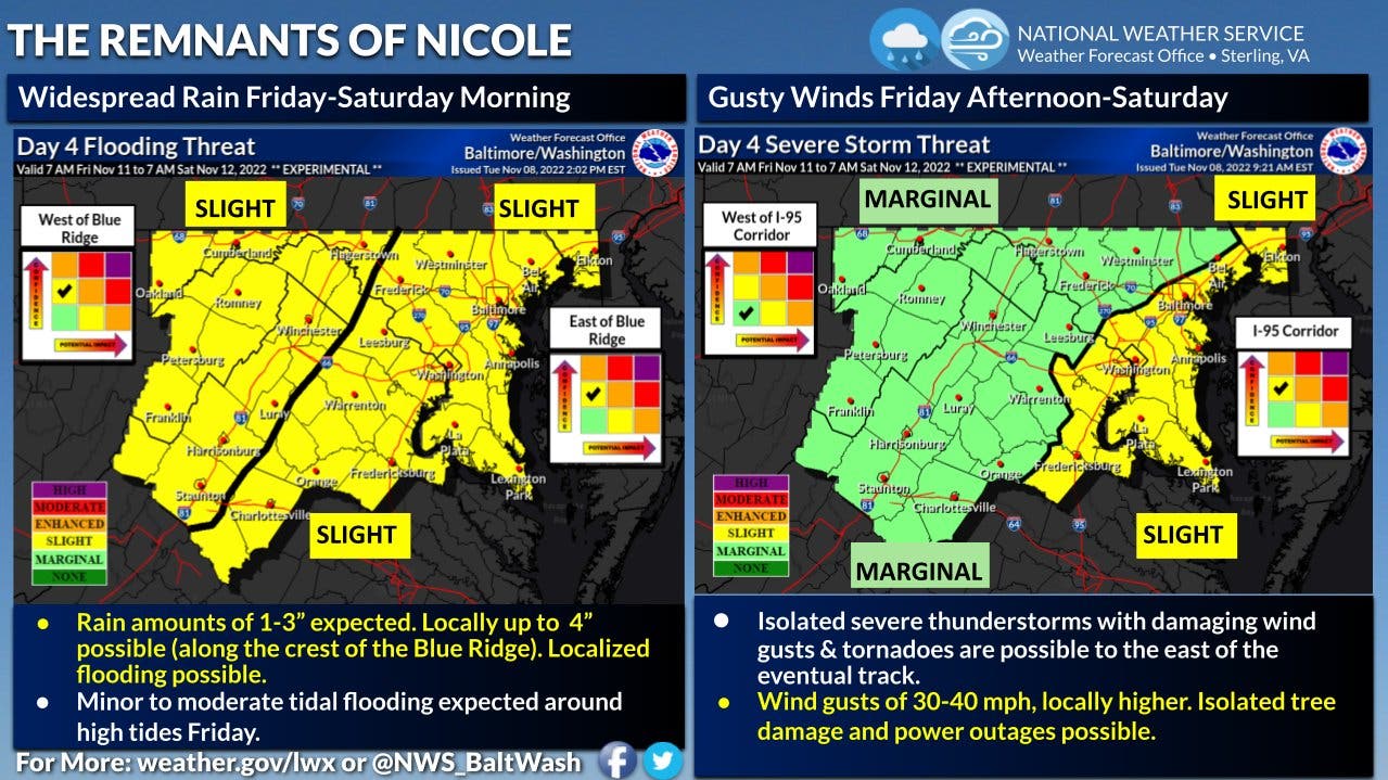
According to the National Weather Service, rain is expected to cover much of the region on Friday. "We also throw in a thunderstorm threat, some strong, as energy from Nicole arrives from the southwest," the NWS said. "With the likelihood that rain will be moderate to heavy at times, flooding may also become a factor in some locations."
"If we get bursts of rain in a series of waves Friday into Friday night before a cold front sweeps across the region, then flooding of small streams and creeks may be the nuisance of the exiting tropical remnants and surface cold front," the weather service said.
"The exact track of Nicole as it is pulled northward will determine where the worst of the impacts will be in the mid-Atlantic and the Northeast," AccuWeather Senior Meteorologist Paul Walker said in a statement.
The most likely scenario is for the center of Nicole to track through the Piedmont areas of the Southeast and then close to the Appalachians once it reaches the D.C. area. As it makes this journey northward, the storm is likely to draw tropical moisture well inland, Walker said.
.jpg)
Ahead of Nicole’s arrival Friday morning, mild conditions will be in place in major cities along the I-95 corridor, with 70-degree warmth forecast for D.C. on Thursday and Friday, according to AccuWeather reported Wednesday.
According to the Washington Post's Capital Weather Gang, periods of rain are likely most of Friday into Friday evening and could be moderate to heavy at times.
"A few thunderstorms are also possible during the afternoon into evening as highs reach near 70 to the low 70s and winds gust from the southeast to around 30 mph, perhaps near 40 mph closer to the Chesapeake Bay," the Capital Weather Gang said.
The forecasters are expecting 1 to 3 inches of rain before tapering late Friday night. The best chance of seeing near or more than 3 inches of rain and isolated flooding looks to be north and west of D.C., the forecasters said.
By the weekend, skies clear and temperatures will dip back to November norms, with a high close to 50 for Sunday.
Here's the NWS forecast for Maryland for the next few days:
Wednesday: Sunny, with a high near 58. Northeast wind 6 to 8 mph.
Wednesday Night: Partly cloudy, with a low around 48. East wind 5 to 7 mph becoming light and variable after midnight.
Thursday: Mostly sunny, with a high near 66. Light and variable wind becoming southeast around 6 mph in the morning.
Thursday Night: Scattered showers after 1am. Mostly cloudy, with a low around 56. Southeast wind 3 to 6 mph. Chance of precipitation is 40%.
Friday: Showers, with thunderstorms also possible after 1pm. High near 70. Southeast wind 7 to 17 mph, with gusts as high as 30 mph. Chance of precipitation is 90%.
Friday Night: Showers and possibly a thunderstorm. Low around 58. Chance of precipitation is 90%.
Saturday: Sunny, with a high near 64.
Get more local news delivered straight to your inbox. Sign up for free Patch newsletters and alerts.