Weather
Ian Remnants Spur MD Statewide Preparations, Gale Warnings And Watches
Gov. Hogan announced statewide preparations as the remnants of Hurricane Ian move up the mid-Atlantic, which could cause coastal flooding.


MARYLAND — Gale warnings and watches, along with coastal flood watches, are posted for the Chesapeake Bay and Potomac River, which has spurred statewide preparations in Maryland as the remnants of Hurricane Ian move up the mid-Atlantic.
“We have been preparing on all fronts to deal with the remnants of the storm,” Gov. Larry Hogan said in a statement Friday. “As we always emphasize with potential flooding events, it is critical for drivers to avoid rising waters — ‘turn around, don’t drown.’ We advise Marylanders to watch the forecast closely throughout the weekend and heed local warnings.”
According to the National Weather Service, steady rain is possible late Friday through Monday, accompanied by strong wind gusts. Beginning this afternoon, a coastal flood watch is in effect for St. Mary’s County, and a gale watch is in effect for lower portions of the tidal Potomac and Chesapeake Bay.
Find out what's happening in Across Marylandfor free with the latest updates from Patch.
Marylanders are encouraged to sign up for the free MdReady text alert program by texting ‘MdReady’ to 211MD1, and visit md511.org for travel updates.
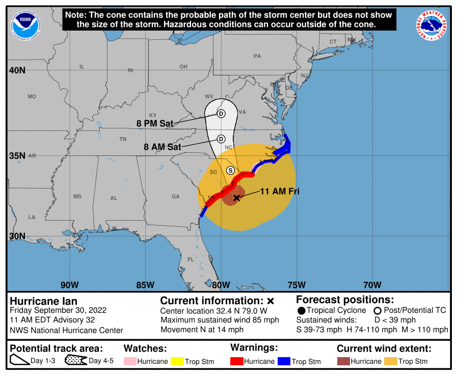
The National Hurricane Center projected Ian's eye to cross South Carolina on Friday before traversing the western portion of North Carolina on Friday night into Saturday. Ian could reach the Virginia-West Virginia-Kentucky border by Saturday evening.
Find out what's happening in Across Marylandfor free with the latest updates from Patch.
Forecasts do not call for the center of the storm to pass directly over Maryland. But Ian's outer bands are still likely to bring heavy rain to the region.
The latest watches and warnings for Maryland are:
- A Gale Warning is in effect from Drum Point to Smith Point and from Cobb Island to Smith Point through 6 AM Saturday.
- A Gale Warning is in effect for the remainder of the Chesapeake Bay and Tidal Potomac from 8 PM this evening until 6 AM Saturday.
- A Wind Advisory is in effect for Calvert and St. Mary's Counties from 6 PM tonight until 4 AM Saturday.
- A Coastal Flood Warning is in effect for St. Mary's County from this afternoon through tonight. Minor coastal flooding is possible elsewhere along vulnerable shorelines of the tidal Potomac River and western shore of the Chesapeake Bay this afternoon through tonight.
- A Gale Watch is in effect from Drum Point to Smith Point and from Cobb Island to Smith Point from Sunday evening through Monday afternoon.
- A Coastal Flood Warning is in effect for St. Mary's County from Saturday through Saturday evening. Minor coastal flooding is possible elsewhere along vulnerable shorelines of the tidal Potomac River and western shore of the Chesapeake Bay through at least Monday.
A hazardous weather outlook was posted by the National Weather Service for the District of Columbia, plus Cecil, Baltimore, Prince George's, Anne Arundel, Charles, St. Marys, Calvert, Montgomery, Howard, and Harford counties.
Much of the Mid-Atlantic region Friday morning was blanketed by clouds extending outward from the center of Hurricane Ian, AccuWeather said. The eye of the storm was located off the coast of South Carolina, but clouds extended northward nearly 1,000 miles, filling the sky as far away as Boston, New York City and Pittsburgh.
Stay up-to-date by viewing all Hurricane Ian coverage on Florida Patch sites here.
Earlier this week, Hogan announced the deployment of an Incident Management Team to the State of Florida to assist with the response.
Ian hit Florida's Gulf Coast on Wednesday as a category 4 hurricane. The storm trekked east across the state, losing wind speed as it traveled inland. That weakening force downgraded Ian to a tropical storm as it reentered the Atlantic Ocean on Thursday. By Friday, Ian was again a Category 1 hurricane with 85 mph winds located about 60 miles east-southeast of Charleston, South Carolina.
Hurricane Ian has caused 21 deaths as of Friday morning, with authorities expecting many more fatalities in two counties where residents were trapped by storm surge. And, hurricane experts predict above-normal storm activity for the next two week in the Atlantic.
State Government Actions Ahead Of Storm
Maryland Department of Emergency Management (MDEM)
- MDEM has activated the State Emergency Operations Center Partial Advance Team, and held Statewide Emergency Manager calls to address potential impacts.
- MDEM reached out to Maryland search and rescue teams to ensure readiness, and facilitated the deployment of an Incident Management Team to the State of Florida.
- MDEM has expanded outreach and messaging regarding Ian and storm preparations.
Maryland State Police
- Troopers will be deployed throughout the state as efficiently as possible to address any areas where there is a greater need.
- MSP will monitor areas of flash flooding throughout the state and work with other state departments to set up detours if appropriate.
- MSP will monitor social media and share/publish messaging: i.e., if traveling, drivers should reduce their speed, increase following distance, and avoid walking or driving through areas where water appears to be flooding or crossing the roads.
Maryland Department of Transportation
- The State Highway Administration is clearing drainage ditches and stormwater management systems, especially inlets, to ensure positive drainage in the event of heavy rain.
- SHA districts have contacted tree contractors to make sure they are prepared for the storm. Regional maintenance shops are preparing high-water signs, ensuring that generators are operational, chainsaws are ready, and fuel resources are adequate.
- The Maryland Transportation Authority is monitoring weather and wind conditions and prepared to implement appropriate warnings or restrictions on bridges. Drains and ditches have been inspected and cleared of debris.
- Maryland Transit Administration crews are prepared to clear tracks and stations of debris, and will implement bus diversions should conditions warrant.
- BWI Thurgood Marshall Airport is monitoring conditions, securing loose materials, and preparing to alert travelers regarding any delays and cancellations.
Maryland Department of the Environment
- MDE’s Water and Science Administration will notify high and significant hazard dam owners and operators to monitor the weather and reduce pool levels if possible, check all emergency equipment (including backup power systems), review emergency action plans and update emergency contacts. WSA will also contact wastewater treatment plants and drinking water facilities to take precautions.
- MDE’s hazmat team is prepared to respond statewide to chemical or oil spills as necessary during the event.
- MDE’s Land and Materials Administration advised landfill and other solid waste facility operators to take steps to prepare for the possible storm and associated precipitation by ensuring good coverage of waste, pumping down leachate storage facilities, and securing the site for possible high winds and heavy precipitation. LMA will also notify underground fuel storage tank owners and certified contractors to be prepared to protect excavations for tank removals and installations.
Maryland Department of Natural Resources
- DNR has trailer-able boats and experienced operators, if needed. Its coastal resiliency and restoration teams have already been in contact with sister states to discuss shoreline rebuilding and reconstruction. A team of water quality experts is on hand to assist with monitoring and sampling post-storm.
- Natural Resources Police has equipment, officers, and supervisors available to assist affected states and communities. It can help with boat deployments, mission control support, search and recovery/rescue missions, and security.
Maryland Department of Human Services
- DHS has sent out situational awareness messaging to state and local partners, confirmed all fleet vehicles assigned for emergencies are operational, and prepared additional shelter supplies for deployment if needed.
Maryland Department of Disabilities
- MDOD is pre-positioning assistive technology kits in case evacuation shelters are opened, raising awareness and preparedness in the disability community through social media channels, and preparing to stand up its constituent services hotline to receive requests and provide referrals for Marylanders with disabilities who are affected by the storm.
Maryland Weather Forecast
Friday: Cloudy, with a high near 68. Northeast wind 14 to 16 mph, with gusts as high as 28 mph.
Friday Night: Rain, with thunderstorms also possible after 2am. Low around 57. Breezy, with a northeast wind 15 to 21 mph, with gusts as high as 39 mph. Chance of precipitation is 90%. New rainfall amounts between a half and three quarters of an inch possible.
Saturday: Rain likely and possibly a thunderstorm before 11am, then rain likely between 11am and 2pm, then rain likely and possibly a thunderstorm after 2pm. Cloudy, with a high near 66. Breezy, with a northeast wind 18 to 20 mph, with gusts as high as 40 mph. Chance of precipitation is 70%. New rainfall amounts between a quarter and half of an inch possible.
Saturday Night: Rain likely and possibly a thunderstorm. Cloudy, with a low around 58. Northeast wind around 14 mph, with gusts as high as 29 mph. Chance of precipitation is 60%. New precipitation amounts between a tenth and quarter of an inch, except higher amounts possible in thunderstorms.
Sunday: Rain likely, mainly after 2pm. Cloudy, with a high near 64. Northeast wind 15 to 18 mph, with gusts as high as 32 mph. Chance of precipitation is 70%.
Sunday Night: Rain likely, mainly before 8pm. Mostly cloudy, with a low around 52. Chance of precipitation is 60%.
Atlantic Hurricane Season Forecast
The experts at Colorado State issued a short-term forecast for the next two weeks of the hurricane season, and they believe that period has the highest probability of above-normal activity.
Ian will go down as one of the strongest storms in U.S. history, reaching the upper limits of Category 4 status with sustained winds of 155 mph, just 2 mph under Category 5 strength. Ian tied with 2004′s Charley and a 1919 Keys hurricane as Florida’s fourth-strongest direct strike on record, according to Colorado State University meteorologist and hurricane expert Philip Klotzbach. The only hurricanes to top Ian included: Michael in 2018, Andrew in 1992 and the Labor Day Hurricane of 1935.
This increased tropical storm activity in the Atlantic comes after a relatively inactive August. The Atlantic hurricane season runs from June 1 to Nov. 30, and September through November are typically the most active months.
Forecasters at the National Oceanic Atmospheric Administration's Climate Prediction Center predicted an active hurricane center earlier this year. Forecasters said the ongoing La Niña, in addition to above-average ocean temperatures, signals a 65 percent chance the 2022 hurricane season will be above normal.
They predicted 14 to 21 named storms with winds of 39 mph or higher. Of those, anywhere from six to 10 of the storms could become hurricanes, with winds of 74 mph or higher.
Forecasters predicted this year's season will spawn anywhere from three to six major hurricanes rated a category 3 or higher during the season's most active months — September to November.
Get more local news delivered straight to your inbox. Sign up for free Patch newsletters and alerts.