Weather
Rain, Wind From Powerful Cross-Country Storm To Reach MD: Forecast
The storm that dumped rain on CA is headed to Maryland by the weekend, potentially disrupting travel plans in the region, forecasters say.


MARYLAND — The next storm headed for Maryland could bring with it snowfall in the mountains and rain to the rest of the state, along with messy travel conditions throughout the region, according to forecasters.
The weather system is part of a cross-country front that could entangle travel plans everywhere from California to Chicago to the mid-Atlantic by week's end.
Gusty winds are likely to accompany the storm's rainfall, the National Weather Service said.
Find out what's happening in Across Marylandfor free with the latest updates from Patch.
The front is predicted to move into the area early Thursday afternoon, before intensifying throughout the day and into the night, forecasters said.
"This will be a rainstorm for the I-95 corridor Thursday night into early Friday with gusty winds," AccuWeather Meteorologist Matt Benz said. The outlet added that "the combination of rain and wind can lead to many travel problems on the roads and delays at airports."
Find out what's happening in Across Marylandfor free with the latest updates from Patch.
While much of Maryland will have temperatures too mild for the rain to become snow, the western counties will likely see accumulation, according to forecasts.
"Cool and breezy conditions are expected today with high pressure settling in," the National Weather Service said Tuesday. "Quiet conditions and seasonable temperatures continue through Wednesday before our next storm system arrives Thursday into Friday."
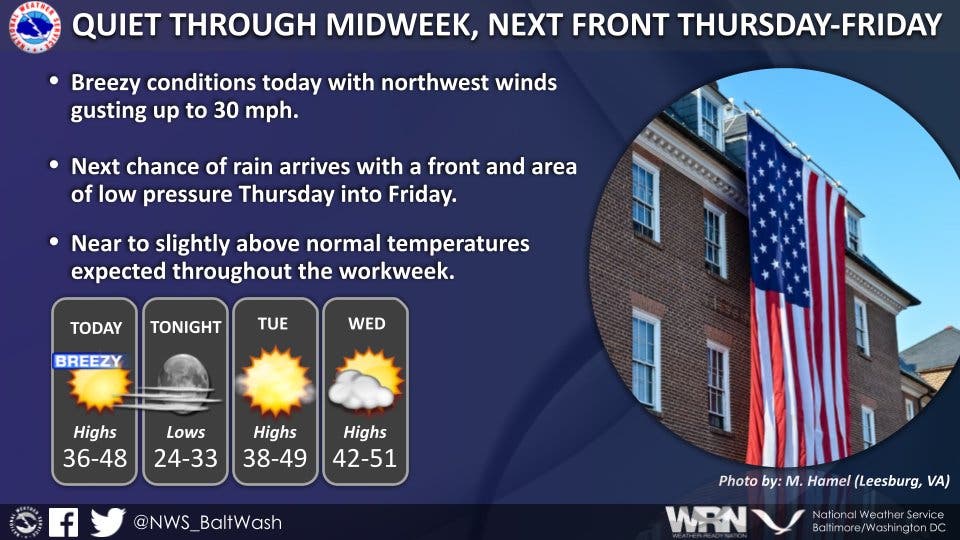
Gusts up to 30 miles per hour, with briefly higher gusts possible, will blow through much of the region. The wind will linger into Friday, but rainfall will likely taper off for most overnight.
Once the storm passes, forecasters expects a colder, breezy weekend in the greater Baltimore-Washington, D.C. region. However, climate forecasts show a 60-80 percent chance of warmer-than-usual weather in the region from Friday through Feb. 3.
Here's the Baltimore-DC region forecast for the rest of the week, according to the National Weather Service:
Tuesday: Cloudy, with a high near 48. Light southwest wind.
Tuesday Night: Cloudy during the early evening, then gradual clearing, with a low around 33. Calm wind.
Wednesday: Increasing clouds, with a high near 47. Calm wind becoming southeast around 5 mph in the afternoon.
Wednesday Night: Mostly cloudy, with a low around 38. Light southeast wind.
Thursday: A chance of rain after 2pm. Cloudy, with a high near 56. Calm wind becoming south 5 to 9 mph in the afternoon. Chance of precipitation is 40%.
Thursday Night: Rain, mainly between 8pm and 2am. Low around 47. Chance of precipitation is 100%.
Friday: A chance of rain before 8am, then a chance of showers after 8am. Mostly cloudy, with a high near 52. Chance of precipitation is 40%.
Friday Night: A chance of rain showers before 8pm, then a chance of rain and snow showers after 2am. Mostly cloudy, with a low around 34. Chance of precipitation is 30%.
Saturday: A chance of rain and snow showers before 8am. Partly sunny, with a high near 43. Chance of precipitation is 30%.
Saturday Night: Partly cloudy, with a low around 30.
Sunday: Sunny, with a high near 46.
Sunday Night: Mostly clear, with a low around 31.
M.L. King Day: Mostly sunny, with a high near 48.
Get more local news delivered straight to your inbox. Sign up for free Patch newsletters and alerts.