Weather
Gusts Of 60 MPH Possible In MD Overnight With Tornado Threat From Storm
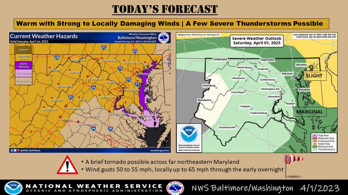
Forecasters said storms with a tornado risk are expected in parts of Maryland, while the state is under a high wind warning Saturday.

MARYLAND — The same system of strong thunderstorms that spawned tornadoes and killed 10 people Friday in the Midwest and South could bring damaging winds and a severe weather threat to Maryland on Saturday, according to the latest National Weather Service forecast.
The NWS on Saturday said a strong cold front Saturday evening will produce showers and thunderstorms, some of which may produce a tornado in northeastern Maryland, according to forecasters.
While temperatures warm back up next week, more active weather looms, the NWS said.
Find out what's happening in Across Marylandfor free with the latest updates from Patch.
A high wind warning is in effect for most of the state until midnight, the National Weather Service said.
Southwest winds of 20 to 23 mph, with gusts as high as 39 mph, are expected during the day, but will ramp up to gusts of 60 mph Saturday.
Find out what's happening in Across Marylandfor free with the latest updates from Patch.
Areas under the high wind warning include: Cecil, Baltimore, Prince George's, Anne Arundel, Charles, Calvert, Montgomery, Howard and Harford counties.
Related: 11 Dead In Midwest, South Tornado Outbreak; More Storms To Come
Communities under the warning include: Frederick, Eldersburg, Westminster, Reisterstown, Cockeysville, Elkton, Baltimore, Bowie, Suitland-Silver Hill, Clinton, College Park, Greenbelt, Laurel, Camp Springs, Glen Burnie, Annapolis, Severn, South Gate, Severna Park, Arnold, Odenton, St. Charles, Waldorf, Chesapeake Beach, Huntingtown, Dunkirk, North Beach, Lusby,
Germantown, Damascus, Bethesda, Rockville, Gaithersburg, Silver Spring, Lisbon, Columbia, Ellicott City, Jarrettsville and Aberdeen.
"Damaging winds will blow down trees and power lines," the weather service said. "Widespread power outages are expected. Travel will be difficult, especially for high profile vehicles."
Here’s a look at the extended forecast around Maryland for the weekend:
Saturday: Showers likely and possibly a thunderstorm before 3pm. Partly sunny, with a high near 77. Breezy, with a southwest wind 20 to 23 mph, with gusts as high as 39 mph. Chance of precipitation is 60%. New rainfall amounts of less than a tenth of an inch, except higher amounts possible in thunderstorms.
Saturday Night: Scattered showers and thunderstorms before midnight. Mostly cloudy, with a low around 41. Windy, with a west wind 22 to 32 mph, with gusts as high as 60 mph. Chance of precipitation is 40%.
Sunday: Sunny, with a high near 57. Breezy, with a northwest wind 17 to 22 mph decreasing to 11 to 16 mph in the afternoon. Winds could gust as high as 34 mph.
Sunday Night: Clear, with a low around 43. North wind 5 to 7 mph becoming light and variable.
Monday: Sunny, with a high near 70. South wind 8 to 15 mph, with gusts as high as 22 mph.
Get more local news delivered straight to your inbox. Sign up for free Patch newsletters and alerts.