Weather
Will Hurricane Irma Hit Maryland?
Deadly Hurricane Irma was a Category 4 storm Friday as she headed for Cuba. Could she bring flooding to Maryland?

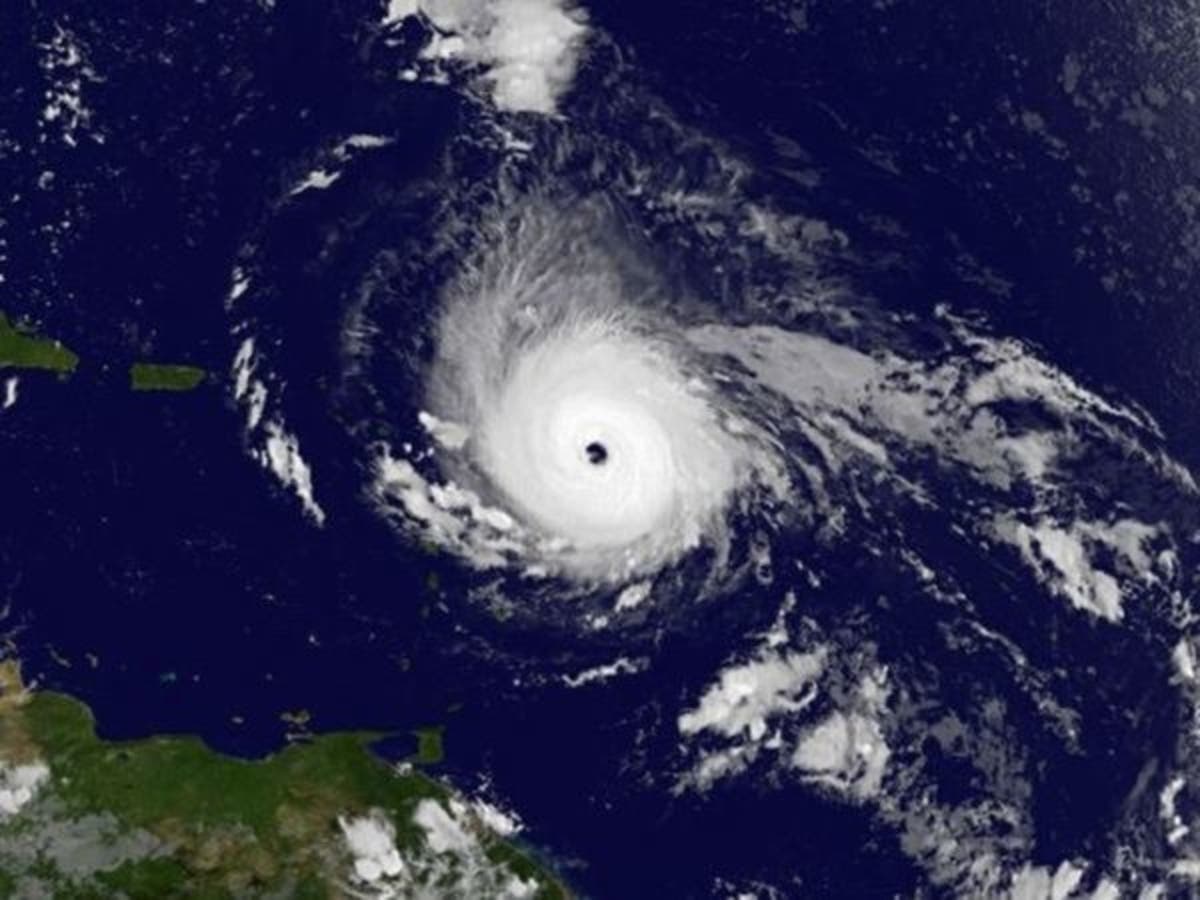
As Hurricane Irma devastated Caribbean islands and killed at least 10 people on a path toward Florida, weather forecasters along the East Coast kept trying to estimate the path of the powerful Category 4 storm. Irma is likely on a collision course with Cuba and a wide swath of the East Coast, including part of Maryland if it turns north once it reaches Florida, which computer models predict.
For now, the National Hurricane Center says the deadly storm, which was the strongest hurricane in the Atlantic's history, will make landfall in southern Florida this weekend. But forecasters are warning everyone in coastal areas to be prepared, with some models suggesting the storm will turn north and follow the coast of Florida into Georgia, the Carolinas, and possibly the Mid-Atlantic states. But, the unpredictable nature of hurricanes makes an exact forecast difficult.
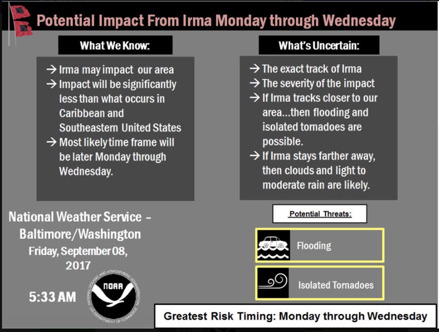
The National Weather Service says that if Hurricane Irma tracks near the mid-Atlantic, it would not be until next week. Flooding rain, damaging winds, tornadoes and tidal flooding are threats Maryland could face, weather officials said.
Find out what's happening in Dundalkfor free with the latest updates from Patch.
Here are the latest updates Friday morning:
- The forecast in Maryland calls for sunny skies Thursday through the weekend, with temps topping out in the low 70s. If Hurricane Irma tracks near the mid-Atlantic, it would not be until Monday, Sept. 11, to Wednesday, Sept. 13, the National Weather Service says.
- Hurricane Irma, the most powerful Atlantic storm ever recorded, churned between Cuba and the Bahamas Friday morning, and still packed maximum sustained winds of 150 m.p.h. The eye is expected to near the Florida keys and southern Florida peninsula by Sunday morning.
Watch: Hurricane Irma Pummels The Caribbean; Florida Could Be Next
Find out what's happening in Dundalkfor free with the latest updates from Patch.
The National Weather Service says that if Hurricane Irma tracks near the mid-Atlantic, it would not be until Monday at the earliest. Flooding rain, damaging winds, tornadoes and tidal flooding are threats Maryland could face, weather officials said. (Get Patch’s real-time news alerts or like us on Facebook. For iPhone users, get the free Patch app.)
Irma could still make landfall in the Carolinas or Georgia, but its path seems to have shifted to the west, the hurricane center said in an 5 a.m. post. The newest estimate shows the storm making it to Tennessee before fizzling out. "Everyone in hurricane-prone areas should ensure that they have their hurricane plan in place." (For more hurricane news or local news from Maryland, click here to sign up for real-time news alerts and newsletters from Annapolis Patch, and click here to find your local Maryland Patch. If you have an iPhone, click here to get the free Patch iPhone app.)
New #hurricane watches have been issued for the Turks & Caicos Islands, SE Bahamas & the north coast of #Haiti https://t.co/tW4KeGdBFb #Irma pic.twitter.com/uJmnbDnlY3
— NHC Atlantic Ops (@NHC_Atlantic) September 5, 2017
A hurricane warning has been issued for the Miami-Dade County area in south Florida. Hurricane warnings mean that hurricane conditions are expected within the warning area within 36 hours. Watches mean conditions are possible.
New #hurricane watches have been issued for the Turks & Caicos Islands, SE Bahamas & the north coast of #Haiti https://t.co/tW4KeGdBFb #Irma pic.twitter.com/uJmnbDnlY3
— NHC Atlantic Ops (@NHC_Atlantic) September 5, 2017
The East Coast, including the Carolinas and the Delmarva Peninsula, could see heavy rain, strong winds and coastal flooding from the storm, the Capital Weather Gang says. Two forecast models being considered late Monday showed the storm working its way up to the Georgia and Carolinas by early next week.

While, obviously, the biggest concern lies for Maryland residents lies along the Chesapeake Bay, the storm could also severely affect next week's weather in western parts of the state, according to some computer models.
Irma formed during the peak of the 2017 hurricane season. Forecasters call the period between mid-August and mid-October the “season within the season.” This eight-week period “is often the most active and dangerous time for tropical cyclone activity,” according to NOAA.
The peak period is historically responsible for major spikes in tropical weather activity, NOAA said. In fact, it accounts for roughly 78 percent of all tropical storm days on record. It is also the period when 87 percent of the category 1 and 2 hurricane days on record occurred. In addition, this period is responsible for “a whopping 96 percent of the major (category 3, 4 and 5) hurricane days.”
The conditions gradually become less ripe for development in mid-October when increased wind shear tends to reappear and water and air temperatures cool.
The Atlantic hurricane season runs from June 1 to Nov. 30 each year. Average seasons produce about 12 named storms, of which six become hurricanes. Three of the hurricanes are generally deemed major.
Residents readying for the ongoing season can get tips and advice on the federal government’s Ready.gov website.
Maryland Hurricane History
To find out more about hurricane season and storm preparation, read these related Patch stories:
- Remember Agnes? 14 Maryland Hurricane Names You May Want To Forget
- Hurricane Tips If Storm Hits Maryland
Maryland has been spared "the big one" on most occasions, but for roughly 60 years, named hurricanes have battered our water-oriented state, altering our lifestyles and our history.
Hurricanes Connie and Diane pounded Maryland in October 1955. Just days apart in their torture on the East Coast, the storms caused widespread flooding. Connie essentially came right up the Bay.
Meanwhile, Diane came on land near the Carolina border and turned east to pass over northern Maryland before going back out to sea.
More recently, Hurricane Sandy in October of 2012 made landfall just north of the upper Chesapeake Bay region, and destroyed the Ocean City fishing pier. From there it went on to devastate oceanfront areas of New Jersey and New York.
Residents readying for the upcoming season can get tips and advice on the federal government’s Ready.gov website.To read the full 2017 Atlantic hurricane season prediction report, visit CSU online.![]()
![]()
![]()
![]()
To keep up with potential storm activity, bookmark the National Hurricane Center’s website. For local weather and severe weather alerts, visit the National Weather Service online.
Patch's Sherri Lonon contributed to this report.
Graphics courtesy of the National Hurricane Center
Get more local news delivered straight to your inbox. Sign up for free Patch newsletters and alerts.


