Weather
MD Weather Forecast: Cold Snap Expected As Winter Finally Hits
Enjoy these last few mild days while you can, forecasters say. Maryland could get a taste of winter in the next week or two.

ANNAPOLIS, MD – Enjoy these balmy final days of November and the mostly mild beginning of December. The newest forecasts say winter is about to hit Maryland.
A stormy pattern and much colder air are on deck for the second week of December, though forecasters say it is still too early for specifics. Accuweather says, depending how low the jet stream dips, the Atlantic Seaboard could "turn significantly colder" come mid-December.
It is too early for specifics on the location of snow versus rain, says Accuweather, but expect the weather during December to trend toward stormy and colder for some locations.
Find out what's happening in Dundalkfor free with the latest updates from Patch.
Meanwhile, the Washington, D.C., region could be in for a white Christmas, according to a Capital Weather Gang report. The blog says 19 weather forecasters it follows predict we'll get at least 9 inches of snow and one predicting a whopping 28.4 inches during the 2017-18 season.
The average prediction was 15.6 inches for the D.C. area, with snowfall totals climbing into the 20s and even 30s as you go farther west. The average snowfall at Reagan National Airport is 15.4 inches. At Dulles Airport, it's 22 inches.
Find out what's happening in Dundalkfor free with the latest updates from Patch.
Maryland is most likely to get snow during the month of January, according to forecasts, although we could certainly see some in December and there was even a possibility of getting some on Thanksgiving, although that chance evaporated in the days leading up to the holiday.
"Later in December, perhaps not until the third week, a change will occur where more extreme cold will first enter the northern Rockies, then the Plains, followed by the Upper Midwest, then the Northeast," AccuWeather Lead Long-Range Meteorologist Paul Pastelok said.
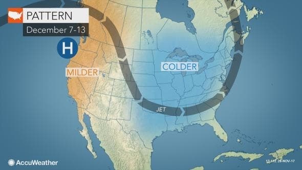
Accuweather doesn't offer specific times for potential storms, but says it is confident the "weather during December will not remain benign and will likely trend stormy and colder for some locations."
The National Weather Service office for Baltimore/Washington agrees that colder days are nearly upon us after near-record highs. Temperatures ranged from the mis 60s to 70 Wednesday afternoon, but a weak and dry cold front will bring cooler temperatures for the second half of the week.
"The weekend will be about 10F degrees cooler and closer to late Nov and early Dec standards. Enjoy it!," the weather service wrote.
NOAA's Climate Prediction Center's 8-14 Day Temperature Outlook indicates enhanced odds for below normal temperatures over the area.
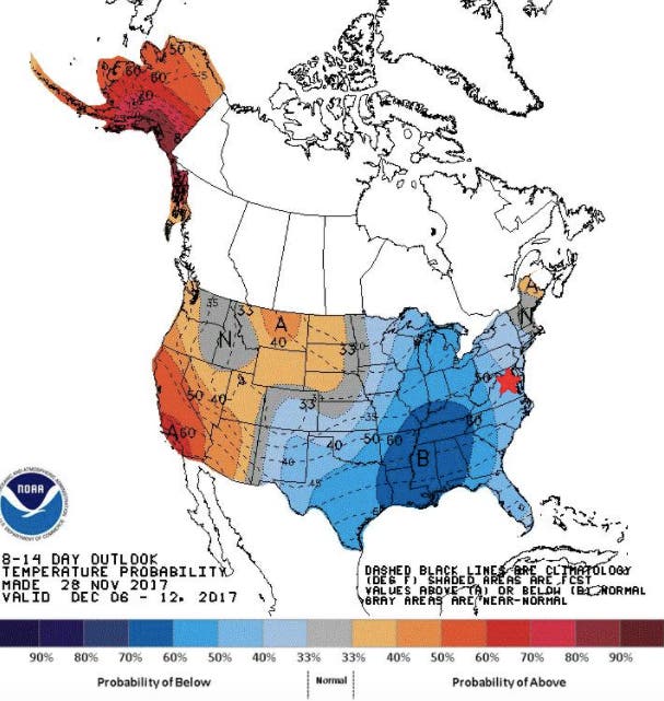
Photo by Aaron Burden on Unsplash
Get more local news delivered straight to your inbox. Sign up for free Patch newsletters and alerts.