Weather
Chance Of Snow This Week In Maryland Forecast
There's a chance of snow this week in Maryland, which would be the first snowfall of the 2017-18 season.


BALTIMORE, MD — Cold north winds will sweep across Maryland late this week, as a weather pattern shifts to bring below-normal temperatures and the possibility of snow, according to forecasters. As of right now, there is a chance of some snow early Friday as low temperatures drop into the 20s, Accuweather says.
It is still too early to know if the snow will in fact materialize, and if it does, how much will fall. Keep your eyes on the forecast if you have weekend travel plans.
AccuWeather meteorologists say they are monitoring the possibility of a storm that could graze the East Coast from New England to Florida with colder temperatures. For the Mid-Atlantic states that means "a bit of morning snow" on Friday.
Find out what's happening in Dundalkfor free with the latest updates from Patch.
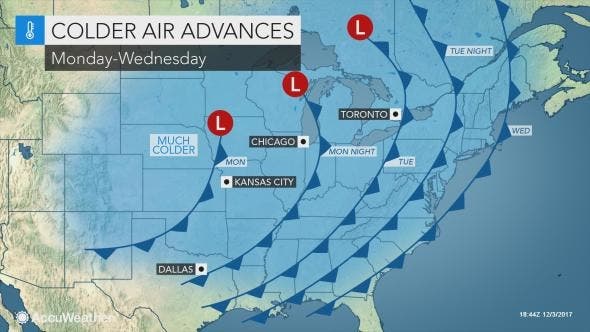
The below-normal temperatures are a result of a "major" pattern change, the National Weather Service says.
The National Weather Service lastweek released an updated 30-day forecast for the month. A "major" pattern change will result in some cold weather for the weeks to come, the National Weather Service says. The longwave pattern change is likely to occur during the first week of December, the NWS estimates.
Find out what's happening in Dundalkfor free with the latest updates from Patch.
"Following a mild start to December, this major pattern change is likely to usher in outbreak of below to much-below normal temperatures at least through mid-December," according to the 30-day outlook, which was released Thursday.
Cold air from Alaska will slide across the Midwest, East and South by the end of this week, bringing wintry conditions to the region. The Capital Weather Gang says the change could be significant enough to bring the first colder-than-normal December since 2010.
"In all, we are forecasting average temperatures of 37-39 degrees, about 1-2 degrees colder than normal," predicts the Capital Weather Gang. "
And the Baltimore/Washington office of the National Weather Service posted this message on Facebook early Monday: "Enjoy the mild weather today! A much colder pattern will take hold during the middle of the week and persist for the foreseeable future."
But before we get to Friday, there will be some rain falling on both Monday night and Tuesday and temperatures will drop steadily headed toward the end of the week.
Here is the latest forecast via the National Weather Service:
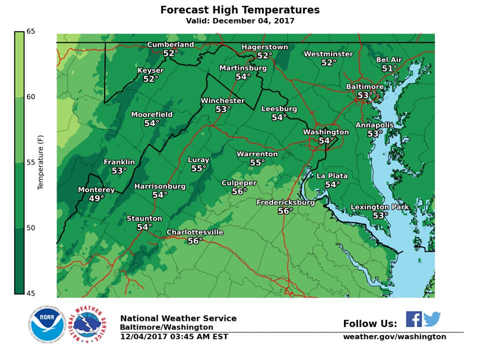
Monday Afternoon: Partly sunny, with a high near 53. Southeast wind around 6 mph.
Tonight: A slight chance of showers after 4am. Mostly cloudy, with a low around 44. Southeast wind around 7 mph. Chance of precipitation is 20%.
Tuesday: Showers likely, mainly after 1pm. Cloudy, with a high near 59. South wind 6 to 10 mph. Chance of precipitation is 70%. New precipitation amounts between a tenth and quarter of an inch possible.
Tuesday Night: Showers. Low around 42. South wind 8 to 13 mph becoming northwest after midnight. Winds could gust as high as 22 mph. Chance of precipitation is 100%. New precipitation amounts between a quarter and half of an inch possible.
Wednesday: Mostly sunny, with a high near 48. West wind 8 to 13 mph.
Wednesday Night: Partly cloudy, with a low around 32.
Thursday: Mostly sunny, with a high near 46.
Thursday Night: Partly cloudy, with a low around 29.
Friday: Partly sunny, with a high near 40.
Friday Night: Mostly cloudy, with a low around 29.
Saturday: Partly sunny, with a high near 39.
Saturday Night: Partly cloudy, with a low around 25.
Sunday: Mostly sunny, with a high near 36.
Photo by Shutterstock; graphics by Accuweather and National Weather Service
Get more local news delivered straight to your inbox. Sign up for free Patch newsletters and alerts.