Weather
Maryland Nor'easter: 70 MPH Winds, Rain And Snow Forecast
The National Weather Service says Maryland could be hit by 70 mph winds, plus rain and even a bit of snow. Bay, Hatem bridges may close.

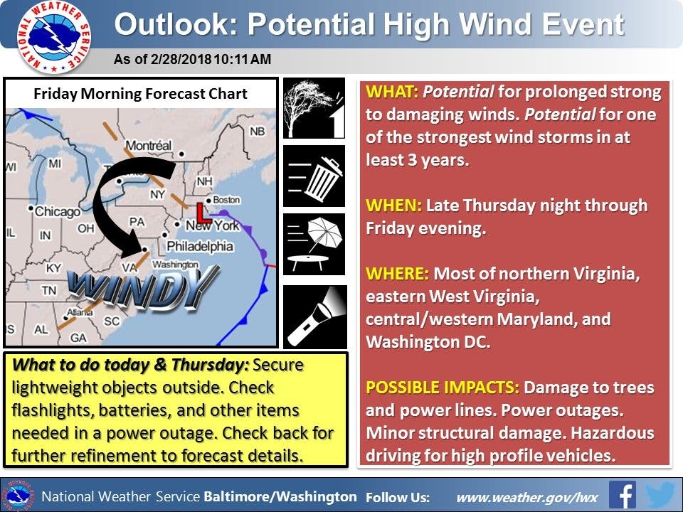
BALTIMORE, MD — As a nor'easter developsg on the Northeast coast, the strongest wind storm in three years could smack Maryland with 60 miles per hour winds Thursday night through Saturday morning, the National Weather Service said in its updated forecast. The Baltimore-Washington DC region is likely to be buffeted by the winds. The powerful storm could send strong winds along the East Coast, cause coastal flooding and beach erosion in New England and New York's Long Island, drop snow in the Midwest and inner East Coast and bring rain to the South.
The National Weather Service has issued a high wind warning, which is in effect from late Thursday night through late Friday night. Northwest winds between 25 to 35 mph with the potential for gusts around 60 mph are expected. Travel will be difficult, especially for high profile vehicles. The specific hours of the warning are from 7 a.m. Friday. to 6 a.m. Saturday.
Those areas are Baltimore and Harford counties, including the cities of Reisterstown, Cockeysville, Baltimore, Jarrettsville, and Aberdeen.
Find out what's happening in Dundalkfor free with the latest updates from Patch.
The warning area could see northwest winds of 25 to 40 mph with gusts around 60 to 70 mph.
These areas are in a high wind watch: District of Columbia, plus Carroll, Baltimore, Prince George's, Anne Arundel, Charles, St. Marys, Calvert, Montgomery, Howard, and Harford counties. Cities in the watch include: Frederick, Ballenger Creek, Eldersburg, Westminster, Reisterstown, Cockeysville, Baltimore, Bowie, Suitland-Silver Hill, Clinton, College Park, Greenbelt, Laurel, Camp Springs, Glen Burnie, Annapolis, Severn, South Gate, Severna Park, Arnold, Odenton, St. Charles, Waldorf, Lexington Park, California, Chesapeake Beach, Huntingtown, Dunkirk, North Beach, Lusby, Prince Frederick, Germantown, Damascus, Bethesda, Rockville, Gaithersburg, Silver Spring, Lisbon, Columbia, Ellicott City, Jarrettsville and Aberdeen.
Find out what's happening in Dundalkfor free with the latest updates from Patch.
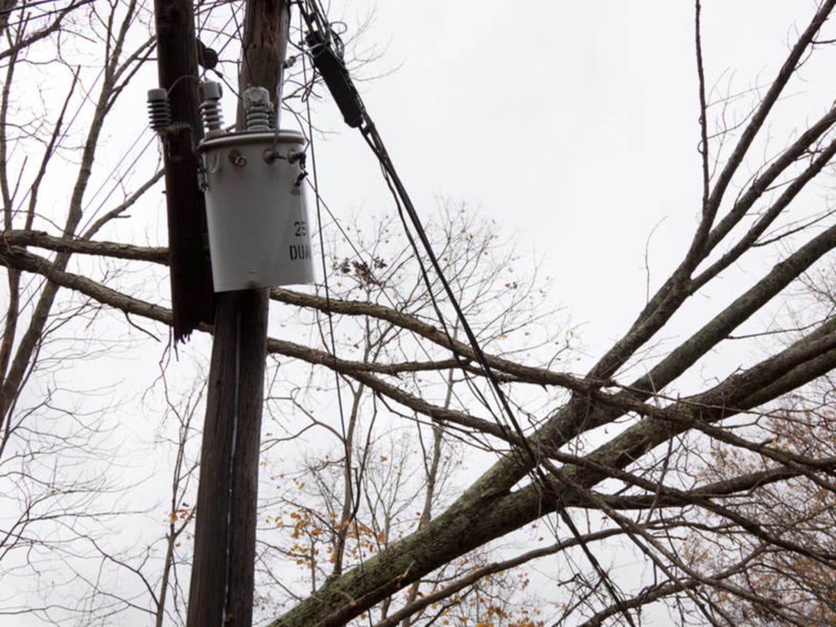
Forecasters say strong winds could begin across much of Maryland Thursday night and reach over 58 mph into Friday, resulting in downed trees and power lines that will cause power outages. Right now there's no firm idea of how much the powerful storm will affect the region, but areas that could be affected by strong winds include most of Northern Virginia, Washington, DC, eastern West Virginia and central/western Virginia.
The severity of the storm depends on how close the storm tracks to the coast, which forecasters will be monitoring into Thursday. NWS's Baltimore-Washington office could issue high wind watches Thursday. And air travel delays are possible if gusts are as strong as predicted.
Exactly how strong the winds become will depend on how much the storm strengthens and its position along the coast, says The Washington Post's Capital Weather Gang, but gusts to at least 50 mph are likely along with sustained winds of at least 30 mph. "It’s not out of the question that sustained winds could reach 40 mph with gusts exceeding 60 mph — which is equivalent to tropical storm strength — especially in the mountains and near the Chesapeake Bay," the Post says.
The strongest winds are likely between about 10 a.m. and 7 p.m. Friday, when gusts could reach 50 to 60 mph, the Weather Gang says.
(For more news like this, find your local Patch here. If you have an iPhone, click here to get the free Patch iPhone app; download the free Patch Android app here.)
The National Weather Service urges residents to prepare for potential power outages and secure lighter items outside.
Don't get excited for any snow, however. Snowfall is expected away from the coast at higher elevations from Maine to West Virginia Friday to early Saturday. Around the Interstate 95 corridor, one to two inches of rain is possible.
Nor'easters form when cold and warm meet and create instability in the atmosphere. Named for the region the storms mostly impact, nor'easters are most common through the winter months and impact large metropolitan regions like DC, Baltimore, New York and Philadelphia.
Here's the latest forecast:
Thursday Afternoon: Rain likely, mainly after 2pm. Cloudy, with a high near 52. Light east wind. Chance of precipitation is 70%. New precipitation amounts between a tenth and quarter of an inch possible.
Tonight: Rain before 11pm, then showers likely, mainly between 11pm and 1am. Low around 40. East wind 5 to 14 mph becoming west after midnight. Winds could gust as high as 28 mph. Chance of precipitation is 90%. New precipitation amounts between a quarter and half of an inch possible.
Friday: A chance of rain showers before 8am, then a chance of rain and snow showers. Mostly cloudy, with a high near 46. Windy, with a northwest wind 18 to 23 mph increasing to 27 to 32 mph in the afternoon. Winds could gust as high as 60 mph. Chance of precipitation is 40%.
Friday Night: A chance of rain and snow showers before 8pm, then a slight chance of snow showers. Mostly cloudy, with a low around 35. Windy, with a northwest wind 23 to 30 mph, with gusts as high as 55 mph. Chance of precipitation is 40%.
Saturday: A slight chance of snow showers before 8am. Partly sunny, with a high near 48. Breezy, with a northwest wind 18 to 20 mph, with gusts as high as 33 mph. Chance of precipitation is 20%.
Saturday Night: Partly cloudy, with a low around 33.
Sunday: Sunny, with a high near 47.
Includes reporting by Patch Editor Emily Leayman
Image via Glynnis Jones/Shutterstock
Get more local news delivered straight to your inbox. Sign up for free Patch newsletters and alerts.


