Weather
MD Weather: Coastal Flooding Likely As 5 Days Of Rain Expected
A storm offshore will bring five days of rain and coastal flooding to Maryland when it arrives, according to the National Weather Service.

MARYLAND — Several days of rain are expected leading into the weekend and prompting alerts for coastal flooding as a storm off the East Coast is likely to cause showers through Monday, according to forecasters.
The National Weather Service says a "persistent coastal storm" has lingered just offshore for days, and while it is likely to weaken before it makes landfall, it will cause five days of wet weather starting Thursday night.
The storm still has some variability, and for much of the storm, rainfall chances hover around 50 percent or higher, forecasters said.
Find out what's happening in Dundalkfor free with the latest updates from Patch.
Some showers are probable beginning late Thursday night heading into Friday. Intermittent rain is expected to continue for another four days, through Monday evening, the National Weather Service said.
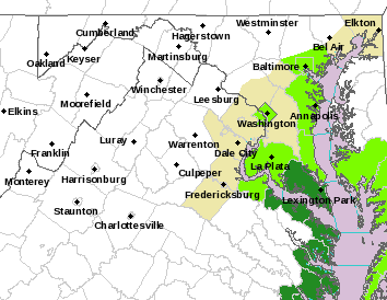
A coastal food advisory is in effect until 7 a.m. Thursday for the shoreline in southern Baltimore County and the city of Baltimore, according to the National Weather Service.
Find out what's happening in Dundalkfor free with the latest updates from Patch.
At 3 feet, flooding is occurring at the end of Thames Street in Baltimore, the NWS said. Water also nearly covers the promenade at the dragon boat dock in the Inner Harbor. At 3 feet, water begins encroaching upon yards in the Bowleys Quarters area.
Tides 1.5 to 2 feet above normal are expected. The next high tide at Fort McHenry Baltimore is at 3:32 p.m. and 4:14 a.m. The next high tide at Bowley Bar is at 3:32 p.m. and 4:14 a.m.
A hazardous weather outlook was issued for the Maryland portion of the Chesapeake Bay, Tidal Potomac River, and I-95 corridor through central Maryland, northern Virginia, and District of Columbia.
Areas in the outlook include: District of Columbia, plus all or parts of Cecil, Baltimore,
Prince George's, Anne Arundel, Charles, St. Marys, Calvert, Montgomery, Howard, Harford counties.
The shoreline in St. Marys County is under a coastal flood warning until 7 a.m. Thursday, especially around the time of high tide.
Here's the forecast for the next seven days:
Wednesday: Mostly sunny, with a high near 75. Northeast wind around 10 mph.
Wednesday Night: Increasing clouds, with a low around 57. East wind around 6 mph.
Thursday: Cloudy, with a high near 71. East wind 7 to 10 mph.
Thursday Night: A chance of showers, mainly after 2am. Mostly cloudy, with a low around 59. East wind 6 to 8 mph. Chance of precipitation is 30%.
Friday: A chance of showers. Mostly cloudy, with a high near 71. East wind around 7 mph. Chance of precipitation is 50%.
Friday Night: A chance of showers. Mostly cloudy, with a low around 61. Chance of precipitation is 50%.
Saturday: A chance of showers, then showers likely and possibly a thunderstorm after 2pm. Mostly cloudy, with a high near 75. Chance of precipitation is 70%.
Saturday Night: Showers likely and possibly a thunderstorm before 8pm, then a chance of showers between 8pm and 2am. Mostly cloudy, with a low around 62. Chance of precipitation is 60%.
Sunday: Showers likely after 2pm. Partly sunny, with a high near 79. Chance of precipitation is 60%.
Sunday Night: Showers likely, mainly before 8pm. Partly cloudy, with a low around 62. Chance of precipitation is 60%.
Monday: A chance of showers and thunderstorms. Mostly sunny, with a high near 80. Chance of precipitation is 40%.
Monday Night: A chance of thunderstorms. Mostly clear, with a low around 58. Chance of precipitation is 30%.
Tuesday: Mostly sunny, with a high near 78.
Get more local news delivered straight to your inbox. Sign up for free Patch newsletters and alerts.


