Weather
MD Weather: Record Heat Looms In Weekend Forecast
Temperatures will soar this weekend across much of Maryland and make it feel like 100 degrees, according to the National Weather Service.

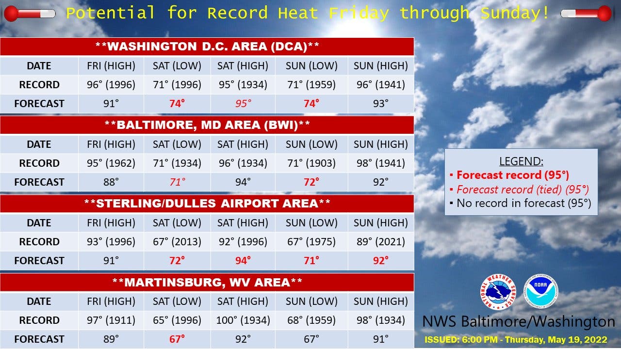
MARYLAND — A hot and humid weekend across Maryland with temperatures in the 90s could set records, prompting the National Weather Service to issue a special weather statement for the region.
Temperatures will be in the 90s on Friday, and heat indices may approach 100 degrees on Saturday, the weather statement says.
"As we head toward the weekend, be mindful of the temperature," the agency said. "Friday through Sunday will see highs in the 90s and heat indices approaching 100 in some locations on Saturday.
Find out what's happening in Dundalkfor free with the latest updates from Patch.
Temperatures will rise into the 90s Friday, Saturday, and Sunday for the first time since last fall, Accuweather.com said.
"Friday will be the first 90-degree day in the Baltimore and Washington region since September. Saturday is forecast to be the hottest day of the weekend, with many locations reaching the mid-90s and heat indices approaching 100," Accuweather predicts. "This level of heat will continue through Sunday."
Find out what's happening in Dundalkfor free with the latest updates from Patch.
The National Weather Service also issued a hazardous weather outlook for the Maryland portion of the Chesapeake Bay, tidal Potomac River, and I-95 corridor through central Maryland, northern Virginia, and District of Columbia.
Heat indices — what it feels like outside when humidity is combined with high temperatures — in the mid-90s are likely Friday afternoon, especially near and south of Washington, D.C., the NWS said.
Heat indices in the mid- to upper 90s are possible Saturday and Sunday afternoons.
Isolated severe thunderstorms are possible Sunday afternoon and evening.
"The abrupt beginning of hot temperatures early in the season after a relatively cool spring brings an increased risk of heat illnesses unless proper precautions are taken for those working or recreating outdoors," the National Weather Service said.
Since many outdoor events are planned this weekend, be aware of the heat, and take extra precautions if you are outside, Accuweather said. Reschedule strenuous activities to early morning or evening. Plan to wear lightweight and loose fitting clothing, and seek shade from the sun. Schedule frequent breaks in shaded or air-conditioning and stay hydrated with non-alcoholic beverages.
The heat combined with surging humidity and sunshine will make it feel like near to above 100 degrees for several hours during the midday and afternoon hours on Saturday, Accuweather said.

Communities included in the special weather statement are: Carroll, Baltimore, Cecil, Prince George's, Anne Arundel, Charles, St. Marys, Calvert, Allegany, Montgomery, Howard, and Harford counties.
Cities under the statement include Eldersburg, Westminster, Reisterstown,Cockeysville, Elkton, Baltimore, Bowie, Suitland-Silver Hill, Clinton, College Park, Greenbelt, Laurel, Camp Springs,
Glen Burnie, Annapolis, Severn, South Gate, Severna Park, Arnold, Odenton, Lusby, Germantown, Damascus, Bethesda, Rockville, Gaithersburg, Silver Spring, Columbia, Ellicott City, Jarrettsville and Aberdeen.
Here's the latest forecast from the National Weather Service for Maryland:
Friday: A chance of showers and thunderstorms, mainly between 4pm and 5pm. Partly sunny, with a high near 91. Light southeast wind becoming south 8 to 13 mph in the morning. Winds could gust as high as 21 mph. Chance of precipitation is 30%.
Friday Night: Partly cloudy, with a low around 73. South wind around 7 mph.
Saturday: Mostly sunny, with a high near 95. West wind 3 to 7 mph.
Saturday Night: Partly cloudy, with a low around 72. Southwest wind around 7 mph.
Sunday: A chance of showers and thunderstorms after 2pm. Mostly sunny, with a high near 90. Southwest wind 7 to 9 mph. Chance of precipitation is 50%.
Sunday Night: A chance of showers and thunderstorms before 2am, then a slight chance of showers. Mostly cloudy, with a low around 64. Chance of precipitation is 50%.
Monday: A chance of showers after 2pm. Partly sunny, with a high near 76. Chance of precipitation is 30%.
Monday Night: A chance of showers. Mostly cloudy, with a low around 58. Chance of precipitation is 30%.
Tuesday: A chance of showers. Mostly cloudy, with a high near 73. Chance of precipitation is 30%.
Get more local news delivered straight to your inbox. Sign up for free Patch newsletters and alerts.


