Crime & Safety
Flooding Likely to Continue Into Sunday in Ocean City, Officials Say
Hurricane Joaquin was expected to turn away from New Jersey, but flooding was still expected.


The most recent high tide brought a round of flooding into Ocean City, and that flooding is likely to continue into Sunday, the Ocean City Office of Emergency Management said late Friday afternoon.
The high tide at 11:52 a.m. Friday left the roads between Second and Third to Sixth streets, and West and Bay to North streets underwater early Friday afternoon, Emergency Management Coordinator Frank Donato said.
At 1:05 p.m., city officials informed residents that many streets in Ocean City are impassable and would be for a few hours. Drivers were reminded not to drive through a flooded roadway. Just after 4:30 p.m., Donato said flood waters were “taking a while to recede, which is expected with nor’easter conditions due to the constant winds not allowing the tidal waters to escape the back bays.”
Find out what's happening in Ocean Cityfor free with the latest updates from Patch.
He also said most streets should be passable by low tide.
“There were a few vehicles that were lost to driving through flood waters that were too high for the vehicle,” Donato said. “However, no motorists were injured or required rescuing. We remind motorists not to drive fast through flood waters.”
Find out what's happening in Ocean Cityfor free with the latest updates from Patch.
Also around 4:30 p.m. Friday, officials said a a Coastal Flood Warning remains in effect through 6 p.m. Sunday, and that moderate to major coastal flooding should be expected after each of the next high tides.
High tides are expected at 12:45 a.m. and 1:08 p.m. Saturday, and on Sunday at 1:42 a.m. and 2:05 p.m.
The same areas that saw flooding on Friday are likely to see flooding throughout the weekend.
Donato said consistent winds that Ocean City has seen the past few days and keeping water in the back bays, and not allowing neighborhoods in that area to dry.
A barricade was set up on Fourth and Fifth streets. Anyone who wants to access Roosevelt Boulevard will need to turn right at 34th Street rather than using the jughandle.
Beach access points have been closed off with temporary dunes, and some stores were boarded up, although some remained open, according to 6 ABC. There were no reports of injuries or rescues in the city on Friday.
Earlier in the day, Donato said flooding wasn’t a problem, following last night’s high tide.
Also on Friday, weather forecasters project Hurricane Joaquin would turn away from New Jersey, but flooding was expected not just in New Jersey, but from South Carolina to Massachusetts.
Atlantic City Electric said it is already responding to reports of outages along the barrier islands on Friday, and is prepared for continuing outages throughout the weekend.
What has your experience been? Do you have any flooding photos you’d like to share with Ocean City Patch? Email them to Anthony.Bellano@patch.com.
Check out some of the flooding on these live cams by clicking these links.
Heritage Surf Shop cam at 4th Street and Boardwalk: http://heritagesurf.com/wavecam/
The Surfers’ View cam at 2nd Street and Boardwalk: http://thesurfersview.com/live-beach-cams/south-jersey/ocean-city
Officials also posted the following weather statement earlier in the day:
Some areas may experience flooding prior to the time of high tide and for several hours past the time of high tide.
Persons in areas of Ocean City that typically experience flooding during storm events should plan to move their vehicles to higher ground.
Very heavy rainfall along with strong gusty winds can be expected through Saturday.
This weather system is in advance of any possible impacts from Hurricane Joaquin later in the weekend.
The Ocean City Office of Emergency Management recommends that residents, business owners and visitors closely monitor weather conditions and forecasts over the next several days in order to stay informed about the possible effects of two significant events.
The Ocean City Beach Patrol is not guarding any beaches in Ocean City. We are currently experiencing very rough surf and there is a strong probability of dangerous rip tides in the ocean. All residents and visitors are strongly discouraged from entering the ocean. Water conditions are extremely dangerous.
Residents, visitors and business owners are encouraged to make appropriate storm preparations. Remove or secure loose objects on porches and around properties in anticipation of high winds.
All Hobie Cat / Sailboat owners are requested to remove their boats from the beach immediately.
Boat owners are reminded to properly secure their boats or remove them from the water.
Contractors are requested to properly secure all work sites. Remove all loose debris and materials that may become a problem in the event of high winds or flooding.
Up to date information can be viewed on the Weather Channel (Channel 61 on the Comcast Cable System) or through other local media outlets. Information is also available on line at: http://www.erh.noaa.gov/er/phi
For further information please tune in to the City’s Government Access Channel (Channel 97 on the Comcast Cable System) or visit: www.ocnj.us
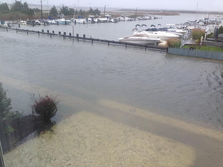
The first attached image from Bayland Drive and Clubhouse Drive was taken at 1:30 p.m. and was provided by Chap Vail
The second and third are of Simpson Avenue, between 10 and 11th streets, and were provided by Sandy Esposito.
The next two, of Simpson Avenue (north end), were provided by Steve Betchner.
The next five of various spots of flooding around Ocean City were provided by Michael Morey
The rest, including the ones of the kids surfing down the street, were provided by Dana DeAngelo
Get more local news delivered straight to your inbox. Sign up for free Patch newsletters and alerts.