Crime & Safety
Storms, Rain Expected To Soak New Jersey For Next 3 Weeks
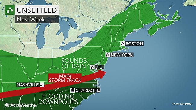
Forecast for the weekend, and beyond: Not going to be nice....


Rain is expected to soak New Jersey for the next three weeks.
In fact, there are no signs of a week-long stretch of rain-free weather anywhere in the region into early June, according to AccuWeather.
As much as an inch of rain is expected to fall in New Jersey and Pennsylvania on Friday and Saturday, so expect travel delays.
Find out what's happening in Tri-Borofor free with the latest updates from Patch.
After that, rainfall will continue to hinder agriculture, construction, sports and other outdoor activities across the region despite a very brief period of dryness, according to the weather service.
"Some subtle changes in the weather pattern will allow small gaps in the rainfall moving forward toward the last part of May," Paul Pastelok, an AccuWeather meteorologist, said in a release. "But the overall pattern will remain wetter than average for a large part of the Eastern states into early June."
Find out what's happening in Tri-Borofor free with the latest updates from Patch.
Portions of New England and the Deep South are likely to have the longest gaps in rainfall while New Jersey and Pennsylvania will be wet the most often.
The rain comes after a very short period of dryness interrupting a very dreary May.
Since April 23, days with rainfall of 0.01 of an inch or more have totaled 11 in Philadelphia and nine in New York City, Pittsburgh, Pennsylvania, and Boston, according to AccuWeather.
Despite the persistent pattern, lower-than-average temperatures will tend to limit the amount of thunderstorm activity, which will reduce the risk of flash and urban flooding, according to AccuWeather.
"With a few exceptions, the greatest potential for flooding downpours will be in the South, where the warm and humid air will make the atmosphere more volatile," Pastelok said.
Here is the National Weather Service forecast for the week and weekend:
Wednesday: Mostly cloudy, with a high near 68. Calm wind.
Wednesday night: Mostly cloudy, with a low around 52. Calm wind.
Thursday: Partly sunny, with a high near 72. East wind 3 to 6 mph.
Thursday night: A slight chance of showers before 2 a.m., then patchy drizzle with a slight chance of showers after 2 a.m. Patchy fog after 2 a.m. Otherwise, mostly cloudy, with a low around 54. Southeast wind around 5 mph becoming calm in the evening. Chance of precipitation is 20 percent.
Friday: Patchy drizzle before 8am, then a chance of showers between 8 a.m. and 2 p.m., then showers likely and possibly a thunderstorm after 2 p.m. Patchy fog before 11am. Otherwise, cloudy, with a high near 73. Calm wind becoming southwest 5 to 8 mph in the morning. Chance of precipitation is 60 percent. New rainfall amounts between a 10th and quarter of an inch, except higher amounts possible in thunderstorms.
Friday night: Showers likely and possibly a thunderstorm before 8 p.m., then a slight chance of showers between 8 p.m. and 2 a.m. Mostly cloudy, with a low around 55. Chance of precipitation is 60 percent. New precipitation amounts of less than a tenth of an inch, except higher amounts possible in thunderstorms.
Saturday: A chance of showers after 2 p.m. Partly sunny, with a high near 72. Chance of precipitation is 30 percent.
Saturday night: A chance of showers before 8 p.m. Partly cloudy, with a low around 46. Chance of precipitation is 30 percent.
Sunday: Mostly sunny, with a high near 63.
Get more local news delivered straight to your inbox. Sign up for free Patch newsletters and alerts.