Weather
Tropical Storm Arthur Forms As Hurricane Season's First Named Storm: See AL Track
Tropical Storm Arthur, newly formed along the TX coast, could bring heavy rains and tornadoes to parts of AL, forecasters said.

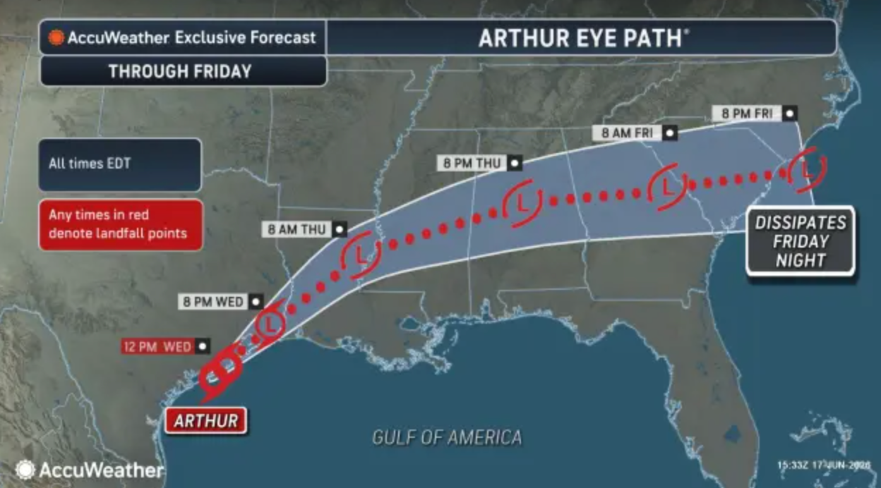
TUSCALOOSA, AL — Tropical Storm Arthur developed Wednesday morning in the Gulf, near the mid-Texas coast,and could bring impacts to Alabama, according to the National Hurricane Center.
Click here to subscribe to our free daily newsletter and breaking news alerts.
Arthur is the first named storm of the 2026 Atlantic hurricane season.
Find out what's happening in Across Alabamafor free with the latest updates from Patch.
The storm’s tropical eye is expected to track northeast across the U.S. Southeast over the next several days, according to AccuWeather forecasters.
The system could bring tropical impacts across southeast Texas through Wednesday night into Louisiana, Mississippi, Alabama, Georgia and then South Carolina by Friday night.
Find out what's happening in Across Alabamafor free with the latest updates from Patch.
These impacts include winds of 39 mph or greater and flooding rainfall, which will be Arthur’s main impact, forecasters said.
Severe thunderstorms, combined with the strong wind gust risk that’s forecast, brings the potential for tornadoes or waterspouts to form from the upper Texas coast to southern Louisiana and the panhandles of Mississippi, Alabama and Florida, forecasters said.
As for the Tuscaloosa Patch coverage area, the greatest impacts are expected Thursday into early Friday.
This will include periods of heavy rain that could produce localized flash flooding, especially in low-lying and poor-drainage areas.
Forecasters also said a few strong to severe thunderstorms are possible for much of Alabama, with damaging wind gusts and isolated tornadoes remaining a concern.
While widespread tropical-storm-force winds are not expected in Tuscaloosa, gusty conditions are possible in stronger storms.
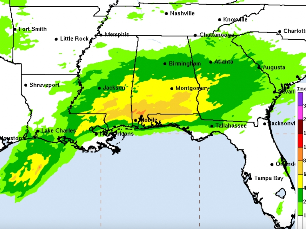
Forecasters emphasize that rainfall and flooding, not wind, are expected to be the primary threat for Alabama as Arthur's remnants move inland. Tropical moisture associated with the system is expected to fuel multiple rounds of showers and thunderstorms across central Alabama.
The tropical storm will enhance moisture and areas of rain already in place, AccuWeather said. Some areas hardest hit might even see 2 to 3 inches of rain per hour, which could overwhelm storm drains and cause localized flooding of streets and highways.
The Houston area has already seen 4 to 7 inches of rain associated with the tropical disturbance over the past two days, meteorologist Matt Devitt shared in a social media post.
While Arthur doesn’t pose a direct threat to Florida, it could indirectly affect the Sunshine State, as remnant moisture from the system is expected to move into the Panhandle on Thursday, Gulf Coast News Now said.
The western Panhandle could see 5 to 7 inches of rain and flooding over the next two days, in addition to a tornado risk in the area, reports said.
A Tropical Storm Warning is in effect Wednesday morning from High Island, Texas, to Morgan City, Louisiana. A Tropical Storm Watch is also in effect for the northeastern Texas coast from Sargent to High Island.
In addition to heavy rains, severe thunderstorms, combined with the strong wind gust risk that’s forecast, brings the potential for tornadoes or waterspouts to form from the upper Texas coast to southern Louisiana and the panhandles of Mississippi, Alabama and Florida, forecasters said.
“It's official! We have our first named storm of the 2026 Atlantic Hurricane season. Arthur has strengthened to a tropical depression with winds of 40 mph. Arthur is expected to move slowly to the northeast and flooding is still expected with the storm. No impacts to us in Tampa Bay,” Denis Philips, chief meteorologist for Tampa Bay 28, wrote in a social media post.
Air Force Reserve Hurricane Hunters investigating the storm on Wednesday morning found peak flight-level winds up to 52 knots, Fox 13’s Paul Dellegatto wrote in a social media post.
This is equivalent to nearly 60 mph, according to a Google wind speed calculator.
Still, “Arthur's proximity to land and strong vertical shear will limit any potential for intensification. The main impacts will be additional heavy rainfall which will likely cause flooding in its path. Arthur will weaken as it moves onshore tonight,” Dellegatto wrote.
Have a news tip or suggestion on how I can improve Tuscaloosa Patch? Maybe you're interested in having your business become one of the latest sponsors for Tuscaloosa Patch? Email all inquiries to me at ryan.phillips@patch.com.
Get more local news delivered straight to your inbox. Sign up for free Patch newsletters and alerts.