Weather
Heavy Rain, Snow To Fall Near Pass Area In Trifecta Storm Series
Get ready for some storms! Plus, see when the rain will hit various cities across the SoCal region.

When will the rain begin and end in your area? Check out the forecast radar reflectivity from the HRRRx model for storms today. Be safe out there! #cawx pic.twitter.com/8QfNzQkZjW
— NWS San Diego (@NWSSanDiego) January 31, 2019
RIVERSIDE COUNTY, CA — Well, it's no polar vortex, but the Banning and Beaumont areas will soon be slammed with our own SoCal version of winter weather. The first of three storms predicted to sweep through the Inland Empire in quick succession will hit the region Thursday, producing showers and thunderstorms, according to the National Weather Service.
Though Friday will be cool and dry, a more powerful storm is predicted for Saturday, following by yet another on Monday.
The anticipated rain has even prompted county officials to issue mandatory evacuation orders on Thursday for select areas near the recent Holy Fire burn area.
Find out what's happening in Banning-Beaumontfor free with the latest updates from Patch.
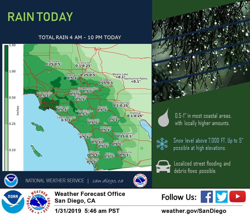
Forecasters said a low pressure system rotating south from the Gulf of Alaska will make landfall Thursday morning, though significant precipitation isn't likely until the afternoon. Temperatures will peak in the low 60s in the Riverside metropolitan area, with rain amounts generally less than an inch, according to the Weather Service.
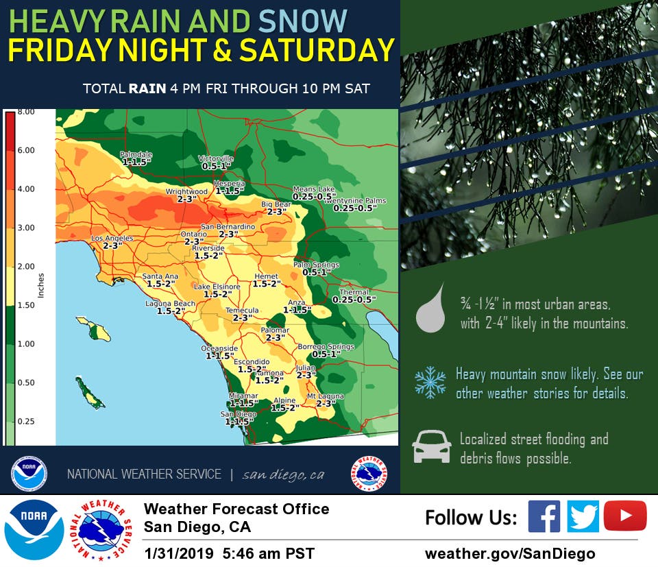
The "fast-moving" system will exit to the east Thursday evening, with showers lingering into Friday morning, the NWS stated. Meteorologists said a second Pacific trough will dominate Southern California late Friday night to Saturday night.
Find out what's happening in Banning-Beaumontfor free with the latest updates from Patch.
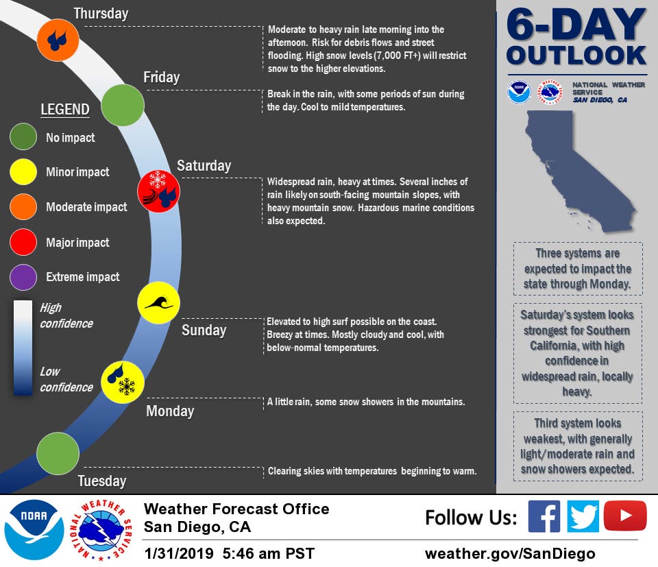
"This will be a larger and slower-moving system, and more widespread and heavier precipitation is expected, along with periods of strong gusty southwest to west winds," according to the NWS. "Snow levels will lower to around 5,500 feet for Saturday afternoon and evening, with snowfall totals exceeding one foot possible above 7,000 feet."
Rainfall in western Riverside County Saturday could range from 1 to 3 inches, while the deserts may receive 1 to 1.5 inches. Isolated locally heavy downpours are possible, and flash flood warnings may be issued, according to the Weather Service.
The final storm in the series is anticipated Sunday night into Monday, but "it is not expected to be as strong as the storm on Saturday," the NWS said.
As for Beaumont in particular, here's what that National Weather Service is forecasting:
Thursday
Showers. High near 58. Southwest wind 5 to 10 mph. Chance of precipitation is 80%. New precipitation amounts between a quarter and half of an inch possible.
Thursday Night
Showers likely, mainly before 7pm. Cloudy, then gradually becoming partly cloudy, with a low around 44. East wind around 5 mph becoming calm in the evening. Chance of precipitation is 60%. New precipitation amounts between a tenth and quarter of an inch possible.
Friday
A chance of rain after 4pm. Partly sunny, with a high near 57. Calm wind becoming south around 5 mph in the morning. Chance of precipitation is 30%. New precipitation amounts of less than a tenth of an inch possible.
Friday Night
Rain likely, mainly after 10pm. Mostly cloudy, with a low around 47. Southwest wind around 5 mph becoming east after midnight. Chance of precipitation is 60%. New precipitation amounts between a half and three quarters of an inch possible.
Saturday
Rain. The rain could be heavy at times. High near 51. East wind around 10 mph becoming south in the afternoon. Winds could gust as high as 20 mph. Chance of precipitation is 100%. New precipitation amounts between 1 and 2 inches possible.
Saturday Night
Showers likely, mainly before 10pm. The rain could be heavy at times. Mostly cloudy, with a low around 40. Chance of precipitation is 70%.
Sunday
A chance of showers. Mostly cloudy, with a high near 49. Chance of precipitation is 30%.
Sunday Night
A chance of showers. Mostly cloudy, with a low around 42.
Monday
Showers likely. Partly sunny, with a high near 48.
Monday Night
A chance of showers. Partly cloudy, with a low around 38.
--
— Main image by Renee Schiavone
Get more local news delivered straight to your inbox. Sign up for free Patch newsletters and alerts.