Weather Forecast Updated: 9:10am 7/16/2013
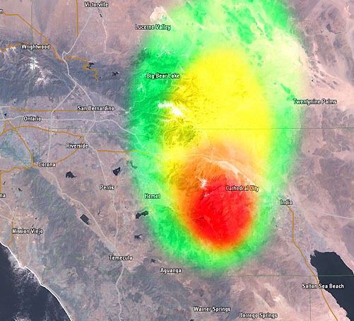
Discussion: Upper air continues to go from south to north. The fire’s progress has moved eastward to just due south of Palm Springs this morning, putting the Western Coachella Valley under an ash cloud. Reports of ash falling into pools and atop surface are coming in.
The fire will continue spreading along the mountain range south of Cathedral City/Palm Springs and move in an easterly direction with time.
Winds are going to be up across the area this afternoon starting around 11am or noon, and calming tonight, much like last night. The fire is moving into drier territory as well as it moves away from the marine air of the Inland Empire and into the dry desert air of the Coachella Valley. SCWXA Air Quality Alerts are in full effect for areas north and northeast of the complex.
Surface wind conditions will remain as followed in the fire vicinity ..
Tuesday
11am – 10 to 15 mph with 20 mph gusts from 270 (West)
2pm – 15 mph with 25 mph gusts from 270 (West)
5pm – 15 mph with 25 mph gusts from 270 (West)
8pm – 10 to 15 mph with 20 mph gusts from 270 (West)
11pm – 5mph from 265 (West)
Find out what's happening in Banning-Beaumontfor free with the latest updates from Patch.
Wednesday
2am – Calm with only 2mph breezes from 300 (Northwest)
5am – Calm with only 2mph breezes from 270 (West)
8am – Calm with only 2mph breezes from 270 (West)
11am – Calm with only 2mph breezes from 290 (Northwest)