Health & Fitness
Transcontinental Retrograding Storm System To Bring A Major Increase In Showers and Thunderstorms By Weekend to Next Week
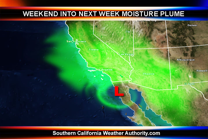
A transcontinental retrograding storm system is traveling through Texas and Oklahoma right now, which developed in the Eastern USA about two days ago. This storm system will continue moving west-southwest and into Mexico, eventually pulling moisture into all of Southern California by the weekend and next week.
The track has changed somewhat and the SCWXA Hazardous Weather Outlook was pulled for Tuesday and Wednesday as a result, so enjoy the metro and beach days then. The outlook has not been changed, however the timing has been pushed back to the weekend into next week, so a five to seven day from now time-frame.
As the storm system continues to push into Northwest Mexico by mid-week, expect an increase in dynamics over the Southern California area by the weekend and into next week as we get a very large area of moisture pushing into the area. This is a pretty rare event, having such a system that crossed the entire United States from east to west during any time of the year. Usually we get ex-tropical systems from the Gulf of Mexico, and those are not as rare … however a system from the Northeastern USA to Mexico is extremely rare, if not unheard of in weather history.
Find out what's happening in Banning-Beaumontfor free with the latest updates from Patch.
So over this next week expect conditions to deteriorate across the forecast area, coming to a head this weekend into early next week.
The SCWXA Forecast Product is a specialty product issued by Southern California Weather Authority.com - Southern California's Public Choice for Weather Alerts.
Find out what's happening in Banning-Beaumontfor free with the latest updates from Patch.
For SCWXA Facebook Visit - https://www.facebook.com/SouthernCaliforniaWeatherAuthority
Get SCWXA Weather alerts via email for FREE - http://www.southerncaliforniaweatherauthority.com/e-mailed-alerts/