Weather
Battered By Santa Winds, LA Cooks Under High Pressure Ridge
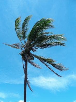
The Santa Ana winds that downed trees and power lines Monday are expected for another day as temperatures climb 10 degress above normal.
LOS ANGELES, CA — High winds again swept mountain, valley, coastal and urban areas of the Southland Tuesday, especially in the San Gabriel Mountains and the Antelope Valley, but were expected to die down Tuesday afternoon.
Temperatures, meanwhile, will be running higher than usual -- 5-10 degrees above normal away from the coast Tuesday and even higher Wednesday, when Downtown L.A. will be 11 degrees above normal at 83 degrees Fahrenheit and Woodland Hills, at 90, will be 16 degrees above normal, said National Weather Service meteorologist Robbie Munroe.
Munroe attributed the above-average heat to a ridge of high pressure aloft combined with warm Santa Ana winds, which are expected beginning this afternoon.
Find out what's happening in Hollywoodfor free with the latest updates from Patch.
A high wind warning, signifying the expectation of 58-mile-per-hour winds or gusts, was scheduled to be in effect in the San Gabriels until 9 a.m. It will be immediately followed by a wind advisory, which denotes winds or gusts of 35 mph, until 2 p.m.
In the Antelope Valley, a high wind warning was in force until 3 a.m., and no other wind warning or advisory was immediately scheduled.
Find out what's happening in Hollywoodfor free with the latest updates from Patch.
Winds of 30-45 mph accompanied by 65-mph gusts were forecast in the San Gabriels, with the strongest winds expected in the Interstate 5 Corridor. In the Antelope Valley, the wind was blowing at between 25 and 40 mph and gusting at up to 60 mph, with the strongest winds occurring in the area's western sector and the foothills.
The weather Service said that overnight, it recorded gusts of 91 miles per hour at Whitaker Peak in the San Gabriel Mountains, 60 mph in the Malibu Hills, 48 mph in Saugus and 38 mph at LAX.
Los Angeles Department of Water & Power crews were working Tuesday morning to restore power to a few thousand customers after strong winds took down power lines. Most customers had power restored by 2 a.m., but more than 2,300 customers were still without power in Studio City, according to the DWP.
The winds will diminish somewhat Tuesday morning but remain gusty through early Tuesday afternoon, forecasters said.
"Winds this strong may down trees and power lines, causing property damage or power outages," according to an NWS statement. "Cross winds can make driving difficult, especially for drivers of high-profile vehicles and vehicles towing trailers."
The wind could down trees and power lines and churn up blowing dust and sand, which could reduce visibility to a quarter-mile or less on the Antelope Valley (14) Freeway and Pearblossom (SR 138) Highway, forecasters said.
A wind advisory was scheduled to be in effect until 9 a.m. on Santa Catalina Island, along the L.A. County Coast, in beach cities, Metropolitan L.A. Downtown Los Angeles and the Hollywood Hills, and until 2 p.m. in the Santa Monica Mountains Recreational Area and the Santa Clarita, San Fernando and San Gabriel valleys. The San Gabriel Valley was added to the areas subject to advisories only last night.
North winds of between 15 and 25 mph along with 40-mph gusts were expected in Los Angeles and on Santa Catalina Island Tuesday while in the San Fernando, Santa Clarita and San Gabriel Valleys, winds were expected to blow at between 20-30 mph with gusts of up to 50 mph.
Along the L.A. County coast, including Santa Catalina Island, a beach hazard statement -- a notch less alarming than a high surf advisory -- will be in effect through Wednesday afternoon, with surf of between 3 and 6 feet expected.
"A beach hazards statement is issued when threats such as rip currents, longshore currents, sneaker waves and other hazards create life-threatening conditions in the surf zone," said an NWS statement. "Caution should be used when in or near the water."
The NWS forecast sunny skies Tuesday and highs of 63 degrees Fahrenheit on Mount Wilson; 68 in Avalon; 72 in Palmdale and Lancaster; 73 at LAX; 76 in Saugus; 79 in Long Beach and downtown L.A.; 80 in Pasadena, San Gabriel, Burbank; and 81 in Woodland Hills. The sunshine will prevail through at least Monday. Temperatures will be in the 70s and 80s this week and highest Wednesday, when they'll reach 90 in Woodland Hills and 86 in Pasadena.
The NWS forecast sunny skies in Orange County Tuesday and highs of 66 in Laguna Beach and San Clemente; 69 in Newport Beach; 74 in Irvine and Anaheim; 75 in Mission Viejo; 76 in Fullerton; and 78 in Yorba Linda, which will reach highs of 84 on Wednesday and Saturday. The sunshine will last for at least the next six days.
City News Service; Photo: Shutterstock