Community Corner
National Weather Service Issues Flood Advisory for Lake Elsinore
Radar shows cell that could produce heavy rain showers that could lead to flooding

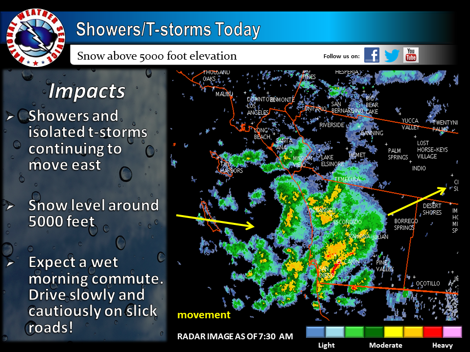
Image courtesy of the National Weather Service
By City News Service
Enough rain to cause flooding, gusty wind, cold weather and mountain snow struck parts of Riverside County on Friday as a late season winter-like storm moved through the region.
Find out what's happening in Lake Elsinore-Wildomarfor free with the latest updates from Patch.
Shortly before 6 a.m., National Weather Service Doppler radar spotted “very heavy rain showers” that could lead to minor flooding in Riverside, Moreno Valley, southern Corona, Temecula and Lake Elsinore. An urban and small stream flood advisory for poor drainage areas will remain in effect until 10 a.m.
“Additional rainfall of one-quarter to one-half inch in is expected over the area this morning,” according to the weather service. “This additional amount of rain will make minor flooding a concern.”
Find out what's happening in Lake Elsinore-Wildomarfor free with the latest updates from Patch.
The storm also caused mountain snow levels to drop to around 5,000 feet this morning, but they are expected to rise later in the day. Up to 5 inches of snow could accumulate in the highest elevations. Winds of 20 to 30 miles per hour are also expected in the mountains, along with gusts to 45 mph.
A winter weather advisory for mountain areas above 5,000 feet is set to expire at 9 p.m.
Drivers on mountain roads were urged to use caution because “brief periods of heavy snow, strong winds and fog will reduce visibilities to a quarter-mile or less at times.”
Elsewhere in the county, rain was falling and forecasters predicted a slight chance of thunderstorms as the storm douses the region for a second day.
Less than a quarter-inch of rain had accumulated in the majority of Riverside County as of 5 a.m. But automated gauges collected .45 inches of rain near Moreno Valley, .43 inches in Portrero Canyon, .31 in Poppet Flat near Banning and .28 inches in Riverside.
Since early Wednesday, wind gusts of 46 miles per hour were recorded in Coachella and Thermal, 43 mph at Pinyon, 38 mph in Thousand Palms and at Toro Peak, 37 mph in Cathedral Canyon and 35 mph in Palm Springs.
A wind advisory for the San Gorgonio Pass near Banning will remain in effect until 4 a.m. Saturday. Areas of west winds of 20 to 30 mph with gusts that could reach 60 mph are expected to continue throughout the advisory period.
Forecasters said the wind may create hazardous driving conditions, especially for motorists in high-profile vehicles. Visibility along some desert roadways could also be reduced by blowing sand and dust.
Although the wind advisory did not extend to the Coachella Valley, forecasters said gusty winds would lash portions of the deserts, such as the northern Coachella Valley north of Interstate 10. A chance of showers and a slight chance of thunderstorms were also forecast for the area.
Get more local news delivered straight to your inbox. Sign up for free Patch newsletters and alerts.