Weather
Flooding Of Napa River Forecasted By NWS
The river is forecast to rise above flood stage as the rain continues, according to the National Weather Service.


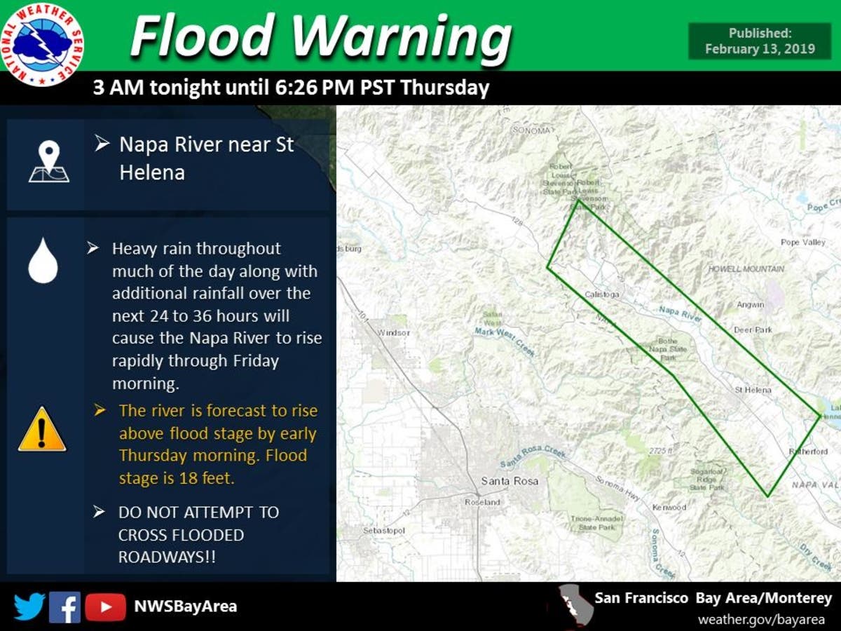
NAPA VALLEY, CA — The National Weather Service San Francisco Bay Area has issued a flood warning for the Napa River after heavy rain overnight and Wednesday morning inundated the area. NWS officials said additional rainfall over the next 24 to 36 hours will cause the Napa and Russian rivers to rapidly rise through Friday morning.
A flood warning is in effect until further notice for the Napa River near St. Helena and in Napa, with weather officials expecting at least minor flooding of the Napa River.
At 9 a.m. Wednesday, the river was at 9.9 feet, with the flood stage set at 25 feet — a point NWS forecasters expect the river to reach by late Thursday morning.
Find out what's happening in Napa Valleyfor free with the latest updates from Patch.
At the Napa River near St. Helena, the flood stage is set at 18 feet — a point weather officials are expecting the river to exceed by early Thursday morning.
"Additional rises are possible thereafter," NWS officials said.
Find out what's happening in Napa Valleyfor free with the latest updates from Patch.
If the river reaches 26 feet in the Napa area there will be moderate flooding, according to the NWS. In the city of Napa, flow would begin to leave the Napa River channel in the South Coombs area, north of Imola Avenue, and the south Oxbow area, near Taylor Street.
"At 27.0 feet...in the City of Napa, moderate flooding begins on the east side of Napa River near Milliken Creek Inn," forecasters said, noting that the flood of Feb. 3, 1998 measured 26.72 feet.
NWS officials said transportation in the Napa Valley would become difficult, with crop losses and erosion damage becoming "serious, with moderate flood damage in lower parts of urban areas along the reach."
According to officials with the NWS San Francisco Bay Area:
*At 25.0 feet...Flood Stage. Flooding of lowest parts of towns in reach begins. Inundation of lowest agricultural land in Napa Valley. Some secondary roads are inundated. Moderate damage from bank erosion and sediment deposition throughout the reach.
* At 24.0 feet...In the City of Napa, flow begins to leave the Napa River channel at Riverpointe (north of Lincoln Avenue).
* At 22.0 feet...Monitor Stage. In the City of Napa, the Napa River Dry Bypass is fully inundated and flow begins to cross McKinstry Street.
* At 20.0 feet...Erosion of lowest agricultural areas along river begins.
A Flood Warning has been issued in Napa County for the Napa River near Napa from 11 am tomorrow until further notice.#CaWx pic.twitter.com/xKZ9B6KgrP
— NWS Bay Area (@NWSBayArea) February 14, 2019
A Flood Warning has been issued in Napa County for the Napa River near St Helena from late tonight until tomorrow evening.#CaWx pic.twitter.com/8olDGKyqV1
— NWS Bay Area (@NWSBayArea) February 14, 2019
Patch will update this post as more information is gathered; please refresh the page for the latest.
Main photo credit: Al Francis/Napasonomaphotos.com; Second and third images via National Weather Service SF Bay Area
Get more local news delivered straight to your inbox. Sign up for free Patch newsletters and alerts.