Weather
Orange County Rain, High Surf: Winter Weather Starts The Week
Orange County saw chilly temperatures, rain and gusting winds to start the last week of October.

ORANGE COUNTY, CA — A storm approaching Southern California from the Pacific northwest could drop a half inch to nearly 2 inches of rain in Los Angeles and Orange County Monday, according to the National Weather Service. The heaviest downpours were expected to strike the San Bernardino Mountains midday, according to reports.
A high surf advisory is in effect at Orange County beaches from 11 a.m. Monday to 3 a.m. Wednesday.
This, all part of a major storm that settled into the middle of the Golden state Sunday, bringing record rains to the Sacramento area.
Find out what's happening in Orange Countyfor free with the latest updates from Patch.
See:
The main rain band would enter Orange County and the Inland Empire by mid-afternoon, making the commute hectic, meteorologists predicted. No thunderstorms were predicted from this event.
Find out what's happening in Orange Countyfor free with the latest updates from Patch.
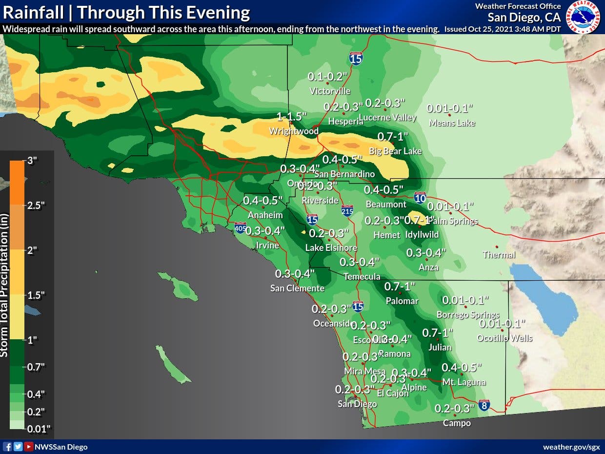
Rainfall totals in Orange County would range from a quarter inch of rain in Irvine and a third of an inch of rain as far south as San Clemente.
Meteorologists report that Orange County is getting "the tail end" of the storm that rained record amounts in Sacramento, Sunday.
Need sandbags?

Find sand and sandbags at the following fire stations. Note: Bring Your Own Shovel!
- Cypress Fire Station 17 4991 Cerritos Avenue
- Garden Grove Fire Station 82 11805 Gilbert Street
- Garden Grove Fire Station 83 12132 Trask Avenue
- Garden Grove Fire Station 84 12191 Valley View Street
- Irvine Fire Station 36 301 E. Yale Loop
- Laguna Niguel Fire Station 49 31461 Street of the Golden Lantern
- Laguna Woods/Laguna Hills Fire Station 22 24001 Paseo de Valencia
- Modjeska Canyon Fire Station 16 28891 Modjeska Canyon Rd
- Rancho Mission Viejo Fire Station 56 56 Sendero Way
- Santa Ana Fire Station 79 1320 East Warner Ave
- Seal Beach Fire Station 48 3131 North Gate Rd
- Silverado Fire Station 14 29402 Silverado Canyon Road
- Silverado Fire Station 15 27172 Silverado Canyon Road
- Trabuco Fire Station 18 30942 Trabuco Canyon Road
- Tustin Fire Station 21 1241 Irvine Blvd.
- Villa Park Fire Station 23 5020 Santiago Canyon Rd
- Yorba Linda Fire Station 53 25415 East La Palma
Cooler temperatures are also expected Monday, with highs in the upper 50s and 60s.
Dry and warmer conditions are expected during the rest of the week.
The main front of the storm system— and the heaviest rain —was expected to firs arrive in the Los Angeles area around noon Monday. The front was expected to move out of the area fairly quickly in the afternoon, the NWS said.
The forecast also calls for the possibility of minor flooding and gusty winds.
Thunderstorms are not expected during the storm, which is expected to move to the east by late Monday evening.
The storm is not expected to bring significant snow to the area, with levels remaining well above 8,000 feet, forecasters said.
After the storm blows through in Orange County you can expect Tuesday temps to warm up slightly after the rain:
Laguna Beach: 64 Monday; 69 Tuesday
Laguna Niguel: 63 Monday; 68 Tuesday
Lake Forest: 63 Monday; 71 Tuesday
Los Alamitos: 64 Monday; 72 Tuesday
Mission Viejo: 62 Monday; 70 Tuesday
Newport Beach: 64 Monday; 69 Tuesday
Orange: 64 Monday; 72 Tuesday
Rancho Santa Margarita: 61 Monday; 70 Tuesday
San Clemente: 64 Monday; 67 Tuesday
San Juan Capistrano: 65 Monday; 69 Tuesday
Get more local news delivered straight to your inbox. Sign up for free Patch newsletters and alerts.