Crime & Safety
Spread Of Destructive Airport Fire Slows; Injuries Reported, Homes Lost In OC, RivCo
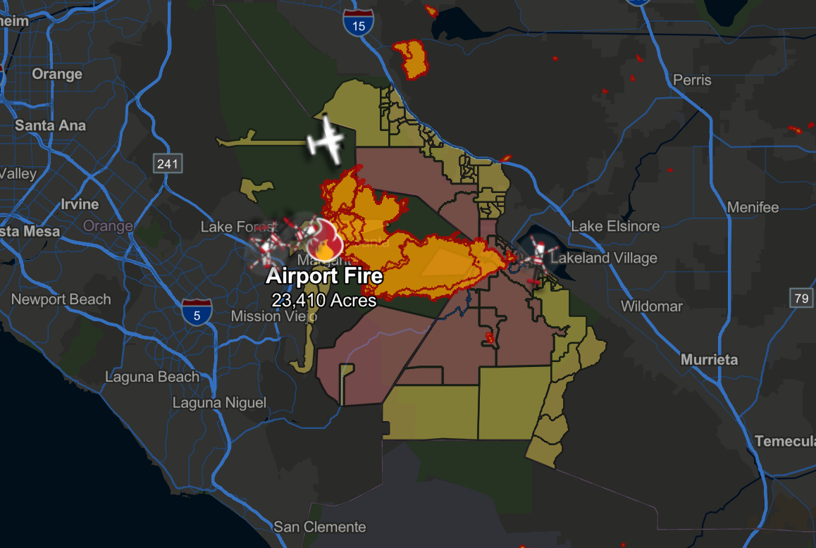
As of 5 p.m. Thursday, firefighters continued to attack the flames — which were kept at 23,410 acres with five percent containment.


TRABUCO CANYON, CA — Aided by lower temperatures, the spread of the brutal Airport Fire burning in Orange and Riverside counties slowed significantly Thursday, firefighters said.
As of Thursday afternoon, the fire was estimated at 23,410 acres, with 5% containment.
There was no immediate word on when the slew of mandatory evacuation orders issued due to the fire would be lifted.
Find out what's happening in Orange Countyfor free with the latest updates from Patch.
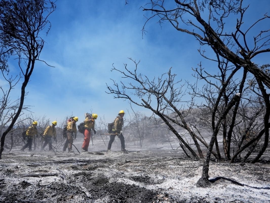
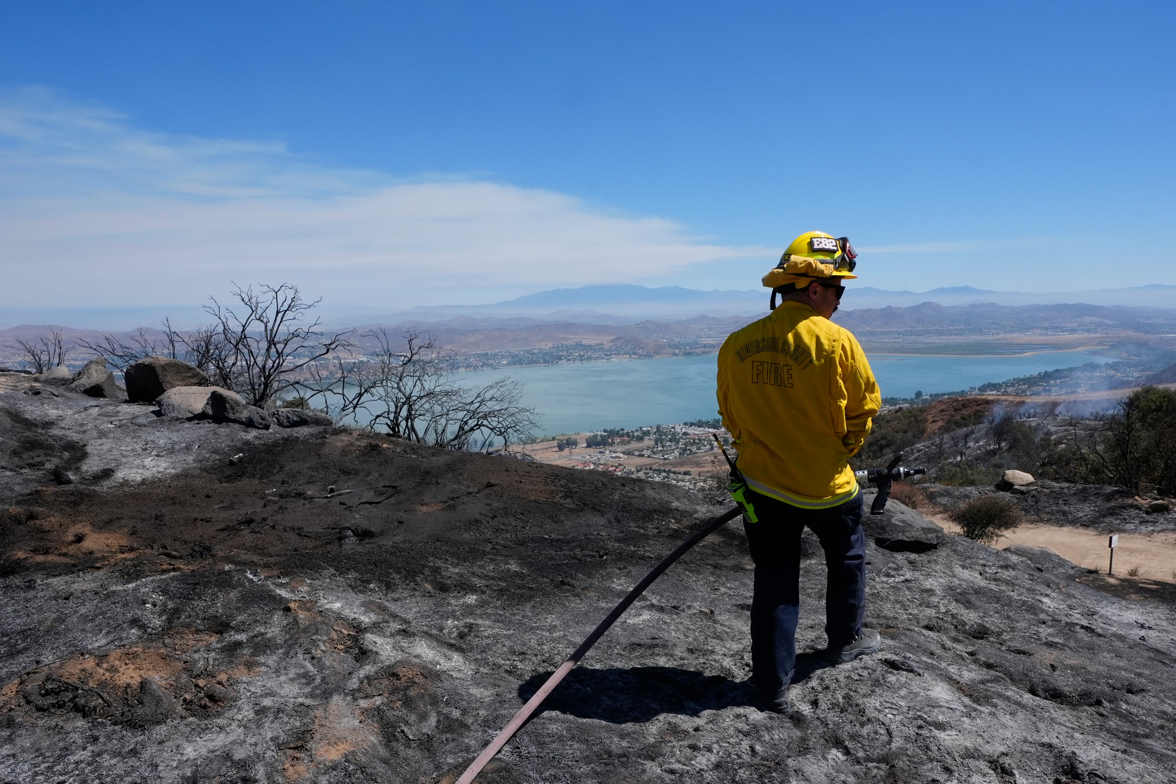
Orange County Fire Authority Capt. Steve Concialdi said about 770 firefighters were battling the blaze "and more are coming to assist."
"This marine layer and cooler temperatures along with the higher relative humidity are helping firefighters grow our containment lines and extinguish hot spots," Concialdi said Thursday morning. "Unfortunately, due to the marine layer, helicopters were unable to fly last night, but starting this morning our firefighters are improving those containment lines and going into those burn areas and extinguishing hot spots."
Find out what's happening in Orange Countyfor free with the latest updates from Patch.
As temperatures rise Thursday, "residents will see smoke," Concialdi warned.
"We are constructing a large dozer containment line from below the fire, starting in Robinson Ranch and behind the communities of Dover Canyon and Coto de Caza all the way to Ortega Highway just in case we have any wind shift or if the Santa Ana winds develop at some point," Concialdi said. "This will be a barrier and will slow the fire and keep the fire away from those communities."
Evacuation Orders Start To Lift
A mandatory evacuation order was previously issued for the Robinson Ranch community in Rancho Santa Margarita, but that order was downgraded to only an evacuation warning on Thursday afternoon. Sheriff's officials said the area will remain open to residents only.
Voluntary evacuation warnings were in place for residents on Rose Canyon Road, Trabuco Creek Road, Trabuco Canyon Road, Trabuco Oaks Drive, Joplin Loop and Cook's Corner. Evacuation warnings were issued Tuesday for Silverado and Modjeska canyons.
Mandatory evacuation warnings in parts of Riverside County were also lifted as of 3 p.m. Thursday, CalFire reported.
According to CalFire, the following areas are having mandatory evacuation orders downgraded to voluntary evacuation orders:
- SOUTH – Temescal Canyon.
- WEST – Lake St.
- EAST – Gateway Dr., Coyote Mesa Dr., Lincoln St.
- NORTH – McVicker Canyon, Park Rd., Patrick Ct.
For a full list of zones, visit CalFire's website.
Aggressive Fire Attack, Reports Of Injuries
Crews were concentrating efforts on the fire's southeastern flank along Ortega Highway to ensure structure protection and douse hot spots, officials said.
The blaze destroyed an unknown number of structures, injured 10 firefighters and two civilians and forced mass evacuations.
"Most of those firefighters injured were heat-related illnesses," Orange County Fire Authority Capt. Steve Concialdi said. "But one did get stung by numerous bees, and one sustained minor burns and the other couple had some injuries from fighting the fire, but all were released from the hospital and are doing well."
At a Wednesday afternoon news conference, OCFA Division Chief Kevin Fetterman reported two civilian injuries.
One victim suffered a medical emergency and the other suffered unspecified burns, Fetterman said.
Cooler temperatures and denuded hillsides from previous burn scars were aiding firefighters Wednesday, resulting in far less spread of the conflagration, Concialdi said. Burn scars from the Holy Fire in 2018 and 2022 also provided much- needed breaks in the fuel feeding the blaze, Concialdi added.
"We got a lot of recovery (Tuesday) night because it cooled down," he said. "Last night, it was 60 degrees, so that helped us improve those containment lines. That containment is expected to grow in our next report."
Fetterman added that the "change in the weather overnight slowed the fire's growth and (allowed) our ground and air forces to significantly improve fire lines."
The agency's new firehawk helicopters have "made a tremendous impact," he said.
"We can confirm that there were some homes damaged and destroyed in the communities around Ortega Highway," but details were still being collected, Concialdi said.
Some structures and vehicles were also believed to have been damaged or destroyed in Riverside County on the outskirts of Lake Elsinore.
As of Thursday morning, the fire was estimated at 23,412 acres and was 5 percent contained. It grew about 1,000 acres overnight when it was 0% contained.
The Orange County Fair and Event Center has taken in 93 horses evacuated due to the fire.
Additionally, the Orange County Board of Supervisors approved an emergency declaration Tuesday in response to the fire, in hopes of acquiring financial resources for the firefight and recovery.
Meanwhile, Gov. Gavin Newsom secured assistance from the Federal Emergency Management Agency for all the fires in the state, including the Airport Fire, the Bridge Fire burning in Los Angeles and San Bernardino counties and the Line Fire in San Bernardino County.
The fire started on Trabuco Creek Road near the remote-controlled airplane airport in Trabuco Canyon at around 1:15 p.m. Monday, the Orange County Fire Authority reported.
By Tuesday, it had blackened 8,510 acres of steep canyons and hillsides, creating a threat to Riverside County's Temescal Valley and Lake Elsinore area residents on the other side of the foothills.
Investigators Explore Cause of Fire
Orange County Fire Authority investigators found that the cause of the fire was unintentional, caused by a spark from heavy equipment being used by two Public Works employees on Trabuco Creek Road earlier that day.
The equipment was being used to replace barriers out in the area to restore a pathway, Orange County Fire Authority Deputy Chief TJ McGovern said during a Monday news conference.
According to investigators, a spark from the equipment resulted in a fire that the two employees were unable to put out.
Closures, Evacuation Orders
Ortega Highway was closed east of Quarry to Grand Avenue in Lake Elsinore. That area had been under a voluntary evacuation warning, but late Tuesday morning, mandatory evacuation orders were issued for areas along the highway near Caspers Park.
There were other roads were closed near the fire:
- Plano Trabuco / Joshua Drive
- Santa Margarita Parkway/Antonio Parkway
- Antonio Parkway/Alas de Paz
- Trabuco Canyon/Trabuco Creek
- Santiago Canyon Road
- Live Oak Canyon Road
A mandatory evacuation order was previously issued for the Robinson Ranch community in Rancho Santa Margarita. Voluntary evacuation warnings were in place for residents on Rose Canyon Road, Trabuco Creek Road, Trabuco Canyon Road, Trabuco Oaks Drive, Joplin Loop and Cook's Corner. Evacuation warnings were issued Tuesday for Silverado and Modjeska canyons
A care and reception shelter for evacuees was established at the Rancho Santa Margarita Bell Tour Regional Community Center, 22232 El Paseo. Large animals can be sheltered at the Orange County Fair Grounds, 88 Fair Drive in Costa Mesa.
Some pets were being sheltered at OC Animal Care at 1630 Victory Road in Tustin, officials said. Mission Viejo Animal Services was also helping residents with shelter for pets.
Additional evacuation warnings were also in effect for a host of Riverside County areas near the fire zone, generally in an area east of the Orange County line, north of the San Diego County line, south of Bedford Motor Way and west of Interstate 15.
Early Tuesday afternoon, some of those warnings became evacuation orders, impacting an area generally north of the San Diego County line, east of the Orange County line, south of Lake Elsinore near the base of Ortega Highway and west of South Main Divide Road/Grand Avenue
An evacuation center was established at Santiago High School, 1395 E. Foothill Parkway, Corona. Large animals can be taken to the Jurupa Valley Animal Shelter, 6851 Van Buren Blvd., according to the Riverside County Fire Department.
See the evacuation updates here.
Also, Cal Fire has an online tool that lets residents and business owners quickly determine the evacuation status for their street address. Find the tool here.
A list of evacuation centers for humans and animals can be found here.
City News Service contributed to this report.
Get more local news delivered straight to your inbox. Sign up for free Patch newsletters and alerts.