Weather
Summer In March: Heatwave Arrives In Coachella Valley
"Many high temperature records are likely to be tied or broken on Thursday and Friday," The National Weather Service meteorologists say.

COACHELLA VALLEY, CA — The heat is on in the Inland Empire over the next week, potentially setting records and prompting officials to caution against strenuous outdoor activity during the hottest periods.
"Many high temperature records are likely to be tied or broken on Thursday and Friday," the National Weather Service said in a Wednesday statement.
.png)
Residents can look for some record warm overnight temperatures on Thursday, mainly for the mountains and inland valleys, with many more on Friday.
Find out what's happening in Palm Desertfor free with the latest updates from Patch.
A Heat Advisory was in place for most of western Riverside County and surrounding inland locations beginning at 10 a.m. Thursday and continuing into Friday night.
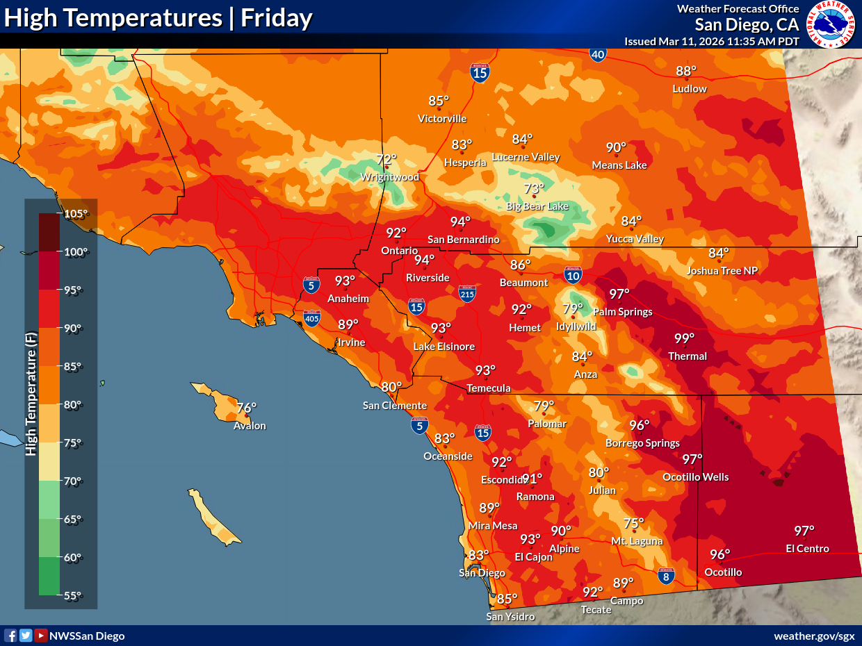
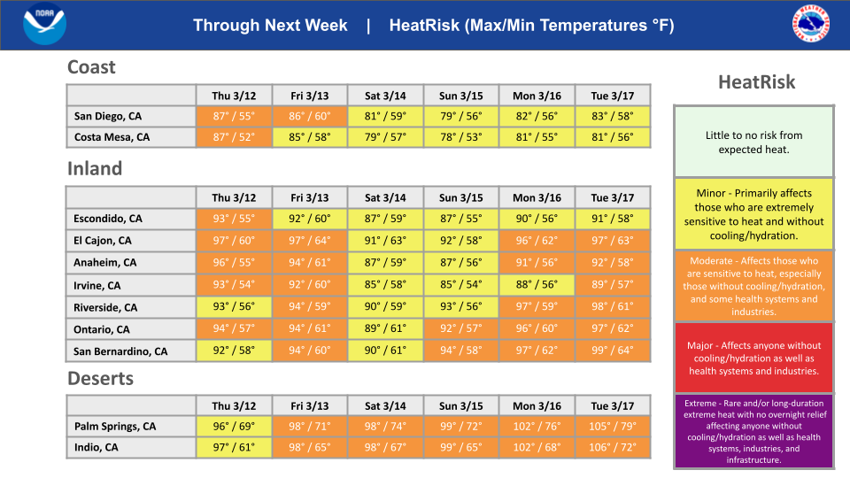
For the Coachella Valley, highs Thursday and Friday will crest in the mid to upper 90s, with lows in the upper 60s. The elevated temps will be summer- like through the weekend and into the middle of next week, holding in the upper 90s and likely rising into the triple digits by Monday, with lows in the low to mid 70s, forecasters said. Next week, many areas will likely see temperatures over 100 degrees.
Find out what's happening in Palm Desertfor free with the latest updates from Patch.
Temperatures on Friday will remain elevated and summer-like, instead of the mid-March typical weather patterns.
"Drink plenty of fluids, stay in air-conditioned rooms and stay out of the sun (during peak heat)," the agency said.
"High temperatures on Tuesday will be as much as 25 to 30 degrees above average for the mountains, inland valleys and high desert, with high temperatures ranging from around 80 near the coast to the mid 90s to 102 for the inland valleys, with the lower deserts reaching 102 to 106," according to the Weather Service. "Some locations in the lower deserts could exceed their all-time record high temperatures for March."
Forecasters, as well as charts published on aviationweather.gov, indicate that high-pressure patterns will largely dominate the weather over California and neighboring states for at least the next seven days. The ridges will blow moisture out of the inland region, likely knocking humidity levels down to the single digits.
No fire weather watches were in effect as of Wednesday.
The NWS said highs in the Riverside metropolitan area Thursday and Friday will top out in the mid-90s, with overnight lows in the upper 50s, followed by a slight cool-down to the upper 80s Saturday and lows in the mid-50s. However, from Sunday to Wednesday, daytime temps will jump back into the mid to upper 90s, with lows generally in the upper 50s or low 60s.
By comparison, during the same time last year, the area highs peaked in the upper 50s to low 60s, according to temperature charts.
Temperatures will likely be identical from the Temecula Valley to the Riverside area for this week, while for most of next week, daytime temps will be two to three degrees cooler, with lows in the low to mid 50s, according to the National Weather Service.
Riverside County officials did not anticipate opening cooling centers during the heat surge this week because it was not forecast to continue for multiple consecutive days. However, after a pause in the sizzle this weekend, another round of record-breaking heat was expected next week.
.png)
Get more local news delivered straight to your inbox. Sign up for free Patch newsletters and alerts.