Community Corner
Saddle Up—Upper Santa Ysabel Truck Trail
Riding within the Cleveland National Forest over to Lake Southerland.


Upper Santa Ysabel Truck Trail is a US Forest Service road that also serves as a trail within the Cleveland National Forest in Ramona. This trail runs in an east-west direction from Pamo Road all the way over to Southerland Dam Road.
The trek is approximately five miles one way and I don’t recommend the trip in the summer heat. There is no shade or water along the way and the breeze can run out on you fairly quickly, so it can get hot. Really hot. Take a look at the description and little map to get your first head's up.
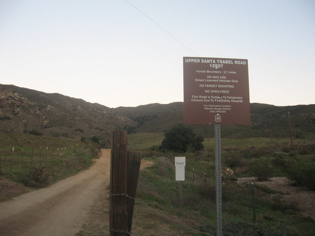
The Forest Service gate entrance is quite a way down Pamo Road, which turns into a dirt road about one mile from the bottom of the hill. The initial hill is a paved road and windy, so go slow. There are cattle and a narrow ridge to maneuver through as well, so keep it slow going, even on the dirt road.
Find out what's happening in Ramonafor free with the latest updates from Patch.
A Forest Adventure Pass is required to park along Pamo Road and utilize the trail system, as it is for any of the trails in this area. There is no formal staging area on the Pamo side of the trail, but there is a small space for parking along the Southerland Dam Road end. It’s not formal, but it is big enough for a couple of smaller horse trailers.
No restrooms or water is available at either end, so be certain to take your porta potty and water for your equine.
Find out what's happening in Ramonafor free with the latest updates from Patch.
Also known as Forest Route 12S07, USYTT goes up, up, up then levels out for the most part and runs along the side of the mountain. Riding out in the area can be a little tricky, as the Forest roads intersect at odd angles at times, so a little research will pay off.
Signs can be confusing too if they exist at all. When I ride in areas like USYTT I use Google Earth prior to my visit so I can get a lay of the land without having to take a vehicle.
Yes the roads are roads of a sort, they are really meant for rangers to be able to get around and check the forest lands and for emergency vehicle egress in case of fires or other emergency.
The vehicle gate is closed and locked most of the time at this entrance, but the horse gate is nearly always accessible. There is a step over that any horse should be able to cross just to the right of the drive-through gate. Just be ever aware that vehicle traffic is possible and drivers will not necessarily be looking out for equestrians.
The rangers use these roads to patrol the area, so you know they are wide enough for a vehicle to drive on and you may occasionally encounter a vehicle. Some areas on this trail may be precarious when encountering a vehicle, as there are steep sides, thus not much room to get out of the way. You can hear vehicles coming from a fair distance on most of the trails, but there are blind corners, so you won’t see them, nor they you at times.
The terrain goes from flat to hilly and depending on how recently it’s rained, the trails can be closed completely. Spring is the most likely time to encounter large ruts and closures, but fall and winter are often times of rainy periods so check for closures before you head out this way.
The rutted trails I find are no real issue for an equestrian, because most vehicles won’t want to attempt to traverse deeply rutted tails while our horses can go around or just walk over most ruts – cuts down on the traffic possibility. Mostly rock free, you can ride side by side with your friends with areas of single-track trails that require single-file riding.
The Upper Santa Ysabel Truck Trail is a one-direction trail that leads out to the Southerland Dam reservoir, and there are some trails out that way to ride around the lake. I have yet to ride around the lake trails, but will get out there after it cools off.
Please check with the rangers and tell them of your intention to ride in the Cleveland National Forest. The Ranger Station is located at 1634 Black Canyon Rd., phone 760-788-0250.
The Black Mountain Truck Trail lies just off the USYTT heading north and east and is closer to the dam side, and I do not recommend that dirt road trail to any equestrian. It is a popular drive for people and vehicles often drive at speeds that would be dangerous to just about any equestrian.
For information regarding closures and conditions visit the Forest Service website.