Politics & Government
Tsunami's Effect on San Diego Coastline Charted by Scripps Institute of Oceanography
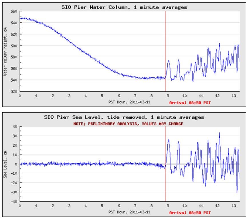
The tsunami arrived Friday at around 8:50 a.m. with a trough-to-crest height of over 40 cm and a period of 36 minutes.

It may be hard to “see” the tsunami here in San Diego. Staring out into the waves it is difficult to detect differences from our day-to-day surf. Just in time to help us out, Scripps Institute of Oceanography’s Coastal Data Information Program released very visual data this afternoon that charts the tsunami’s initial effect on the San Diego coast.
Preliminary analysis of data collected off Scripps Pier shows the tsunami arriving Friday at around 8:50 a.m. with a trough-to-crest height of over 40 cm and a period of 36 minutes.
The swells caused the ocean to briefly rise 2.8 feet in La Jolla, 1.2 feet at San Diego Navy Pier and 2.6 feet in Imperial Beach, according to the National Weather Service.
Find out what's happening in Ramonafor free with the latest updates from Patch.
As of early afternoon, no major problems had been reported locally. About dozen extra San Diego lifeguards and 30 police offices have been patrolling the San Diego coastlines.
“There’s no reason to be alarmed, just be aware,” said Maurice Luque, a spokesman for the San Diego Fire-Rescue Department. “We don’t expect any inundation of water.”
Find out what's happening in Ramonafor free with the latest updates from Patch.
Data collected by Scripps’s Coastal Data Information Program is shared with the West Coast and Alaska Tsunami Warning Center and other institutes to help with research efforts.
City News Service contributed to this report.
Get more local news delivered straight to your inbox. Sign up for free Patch newsletters and alerts.