Politics & Government
Part III The 241 Toll Road Extension: No More Fee-based Pavement South of Oso Parkway in Mission Viejo
An Overview: The 241 Toll Road Extension, CEQA & AESTHETICS

Part III: CEQA & AESTHETICS

“You cain’t fix stupid…stupid is For-ev-er.” Redneck comedian Ron White
Find out what's happening in San Clementefor free with the latest updates from Patch.
“The two most common elements in the universe are hydrogen and stupidity.” Harlan Ellison
Previously in this series: PART I https://patch.com/california/l... PART II https://patch.com/california/l...
Find out what's happening in San Clementefor free with the latest updates from Patch.
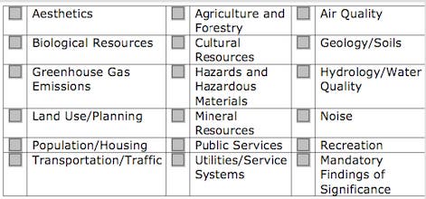
OVERVIEW
Long Range Development Planning (LRDP) mandates that the lead agency for a project perform a professional analysis to address the gamut of environmental factors potentially affected. This leads to a flow chart I’ll include later.
As I introduce each CEQA category alphabetically in subsequent articles, drill down and explain more in depth, I’ll also give the TCA my personal rating, expressed as a grade. Since regarding their comprehension of the severity of the disaster they seem hellbent on creating seems to elude them at an academic, cerebral level, maybe THEY need schoolin’, baby I ain’t foolin’.
Typically, analyst vendors simply pull the California Environmental Quality Act (CEQA) Initial Checklist template up on their screen and begin what’s basically a combined algorithm and matrix decision-making process. There are circumstances where the National Environmental Policy Act (NEPA) is either the parent or supplemental document process depending (Environmental Impact Statement--EIS), but we'll confine ourselves to CEQA here.
If you like confusion, or into convoluted spaghetti graphics, a link to the CEQA flow chart: https://www.califaep.org/polic...
CEQA Initial Analysis Checklist
Theoretically, an arduous, exhaustive, complex and lengthy task of matching categories with project elements and potential impacts, practices and/or devices to mitigate should take place.
The analyst should attempt to provide stakeholders a list of jurisdictional oversight agencies, including public resource trustee agencies, that must be alerted through the State Clearinghouse (SCH). Each project gets its own SCH # for future communication, investigation and research references: http://www.ceqanet.ca.gov
Once filed, a Notice of Preparation (NOP) is automatically transmitted to the agencies and stakeholders identified by the applicant. It opens the comment period before a Draft Environmental Impact Report is produced. Comment periods are usually no less than 30 days, the lead agency sometimes allows 45-60 day windows, especially over winter holiday periods.
This is where a lot of initial CEQA manipulation occurs: The lead agency can under-value, under-estimate and not list potential affected agencies, hence control those notified, plus the scrutiny and duration of the oversight process itself. By downgrading/low-balling impacts in the NOP, they also gain further advantages we’ll hit later.
Initially, we’re going to focus and rely heavily upon the Dept. Of Transportation (Caltrans) AESTHETIC guidelines for several reasons, among which is that eventually they’ll be the agency that will manage and maintain any major arterial extensions.
They’ll also be held responsible/accountable for TCA’s “certs”, i.e., ramifications and consequences of approvals and permits by (if applicable) jurisdictional oversight entities.
A tool you will need to navigate this and future category columns is critical to understanding the context, the meaning of one word: What exactly IS “mitigation” according to CEQA?
- Avoiding the impact altogether by not taking a certain action or parts of an action.
- Minimizing impact by limiting the degree or magnitude of the action and its implementation.
- Rectifying the impact by repairing, rehabilitating, or restoring the impacted environment.
- Reducing or eliminating the impact over time by preservation and maintenance operations during the life of the action.
- Compensating for the impact by replacing or providing substitute resources or environments.
Let’s wade in, paddle out into the lineup, and take off:
ENVIRONMENTAL SETTING, IMPACTS, AND MITIGATION MEASURES
AESTHETICS
TCA Grade "F": What are these people smoking?
Aesthetics is many times one of the least understood, discussed, and under-valued CEQA categories. It can be a tremendous tool regarding not only mitigations for visual impairments and unacceptable view alterations, but add to a project’s “cumulative impacts”…..At times killing the project if that pile is insurmountable, cannot be mitigated under fair argument standards.
That accumulation of problems is in the MANDATORY FINDINGS OF SIGNIFICANCE category (see above), which will be our last topic in this series.
“From the perspective of CEQA, the term “AESTHETICS” pertains to the perceived visual quality of an area characterized by one or more visual elements such as an open space, scenic view, or architecture. Aesthetically significant features can occur in a diverse array of environments, ranging from urban centers to rural agricultural lands to natural woodlands. A project can have significant impacts on visual quality if it negatively affects the aesthetically significant features by altering them in part or wholly, e.g., by destroying vegetation integral to a scenic vista, or by constructing a building in an architectural style that conflicts with the existing setting.
Scenic resources, including highways, historic buildings, and natural features, are typically described in city and county general plans. In addition, the California Department of Transportation (Caltrans) lists scenic highways that are officially designated or considered eligible in the state scenic highway system. These resources could all potentially be located within the project area.” Source: http://www.cpuc.ca.gov/Environment/info/esa/sempra-fig/fig/3a_aesthetics.pdf
This chart below might assist a clearer understanding of how each CEQA category’s impacts are rated, so I downloaded this example with a caveat: The link above and this analysis below are taken from, in reference to a particular project "Fiber Optic Cable in Gas Pipelines"
SCG/SDG&E Schedule No. G-FIG 3.A-1 CPUC A.02-03-061
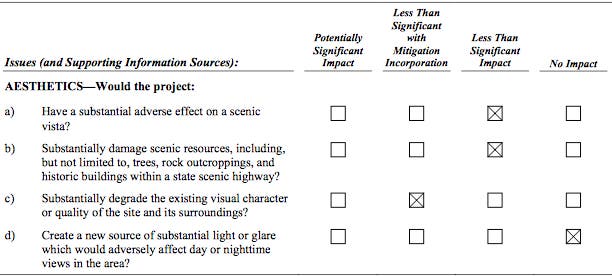
It needs mentioning here that this is another juncture where many a confrontation “breaks bad, goes south.” That’s because the project proponent (applicant) hires vendors who slant their conclusions in their client’s favor, to their benefit, ALWAYS to the lesser extent (less restrictive/less expensive).
Ex.: In the case of (c) above, the analyst will assert that the existing visual character impacts are significant, but can be mitigated via incorporation of certain proffered measures.
I have NEVER in my 20 years in this field EVER observed a lead agency vendor properly, equitably, fairly give proper weight----Plan on them skewing at least one square to the right (to their advantage). Or even blatantly denying that there’s an aspect to mitigate at all.
If the analyst is an in-house, government employee of the lead agency, bet the farm that it’ll be tainted, compromised from the opening bell. Obviously unfair, but that’s how CEQA rolls.
If in opposition, me personally? I mess with the lead agency and vendor’s heads by creating my own matrix with my mitigation conclusions, submit that during public comment periods.
Now apply what you’ve observed so far to the TCA’s Extension Options 13, 14 or 17. I’m opposed to #9, the so-called “Beltway Loop Option,” but I’ll discuss that alternative’s deficiencies at a much later point.
IMHO, all 3 will have “Potentially Significant Impacts” that in sub-sections (a) through (d) (see above) cannot possibly be mitigated. Once they try to extend the 241 beyond Cow Camp Road, a fatally flawed proposal emerges.
In the San Juan Creek Watershed, a monolithic ¾ mile bridge starting from Los Patrones/Cow Camp, transiting the watercourse, flying over the Ortega Highway and penetrating the hills will be a dominant, unnatural and hence distracting physical structure. Rural Ortega Highway? Adios. For-ev-er.
Jump over to the San Clemente side. Not only will residents be forced to look at a similar unnatural monolithic installation (infrastructure carrying the arterial to the I-5) For-ev-er, but travelers will no longer see the crest of the Pico bowl view-shed from the freeway. They’ll see a large cavernous, excretory hole and a major arterial ramp barreling, cascading down at them like a vehicular ski jump. For-ev-er.
For those that distrust or dislike the California Coastal Commission, they might become your new BFF because scenic bluffs and scenic views are highly protected. Since CCC approval, via a Coastal Development Permit, will be mandated, there’s another ally, another appellate venue for NOMI’s if they lose locally. The California Coastal Act has stopped many a developer dead in their tracks: https://www.coastal.ca.gov/coa...
Here's where San Clemente's Open Space, General and Specific Area Management Plans come in because all Cali coastal cities have their programs certified and on file with the CCC. And they're binding, tough to get over, under, around or through, takes a robust amendment to change. A lot is based on case law, and to fight the CCC, reverse or alter an amendment hostile to a city would be a Promethean task.
Note that a view includes sighting from all directions: The residents on the SJC side (San Juan Capo and Rancho Mission Viejo) will now be forced to look at the extension of Los Patrones, the bridge, and the Ortega Highway overhead urbanization. What was once upon a time a verdant, bucolic scenic drive out the Ortega (once you include RMV buildout) will look like an inner city, rife with concrete, stucco and asphalt. For-ev-er.
From the San Clemente side, views from the hills looking down from recreational trails in both directions will be impacted, obscured, infringed upon. RECREATION is another topic for another article, yet those degrading impacts too will be For-ev-er.
I’ll deal with the eminent domain takings, homeowners being forced out, in my LAND USE/PLANNING article. But consider the residents living below the Extension: They’ll lose their view of open space above them.
Many above the Extension will lose their beautiful Pacific sunsets: A significant view loss + property devaluation. White water, coastal ocean views are worth a great deal, aesthetic considerations (not just fiscal worth) included. I’m sure an attorney would plead an illegitimate, unreasonable and uncompensated taking. Not necessarily For-ev-er, depends on the attorney and judge you pull.
On both sides of the hills, intense lighting sufficient to guide vehicles traveling at high speeds, including well-lit shoulders for emergency response, will overwhelm. We’re talking wide swaths, washing out and into extended areas, into fauna habitats. YUGE visual blight. Good-bye night skies, bet the critter’s that forage at night will love that. For-ev-er (ok, ok, only dusk to dawn).
Tunneling? I guess if you’re as experimental and sick as the TCA, openly contemplating a 2-3 mile long tunnel, burying the middle section of the extension (out of sight, out of mind) is a stretch, but not beyond them as proposed mitigation incorporation for this array of visual impacts.
I’ll deal with the biotic implications when we get to BIOLOGICAL RESOURCES.
I’ll also deal with the known dangers and hazards of tunnels in my GEOLOGY/SOILS article. Historically the entire extension candidate area is known to be unstable, La Pata barely completed before an easily predicted landslide occurred, developers/builders successfully litigated by SC HOAs, the list goes on.
Imagine the tragedy, the scenario of that tunnel collapsing, known and knowable unstable soil pockets/slippages ignored, and a significant seismic event burying the unfortunate. Human lives are invaluable, even if they’ve been duped, users who thought themselves safe because it’s Caltrans (the state).
Try to guess who’ll foot the emergency hospital and vehicular damage bills, including subsequent nightmare deep pocket class action lawsuits, tying up a rebuild, rehab or retrofit indefinitely?
Howasbout the views now? Spoil piles of rubble, a protracted recovery, cleanup and remediation period, high/intense daytime activity traffic, the visual impacts upon both the Ortega and Pico/I-5 junction?
The ambulances won’t be driving the 241, it’ll be worthless for years afterwards, maybe never rebuilt. Millions down the drain, lives lost, not a solution but a whole new set of problems. All due to the TCA ignoring the facts beforehand. Preventable.
I guess if you’re sitting in an ergonomically correct chair, in an air-conditioned office complex @ 125 Pacifica in Irvine, looking out and down on the peasants, the riff-raff, the commoners, hey, c’mon, the only SUBSTANTIAL ADVERSE IMPACT you’d experience would be if your grossly inflated salary was cut.
"The mediocre are always at their best---they never let you down.” Jean Giraudoux