Schools
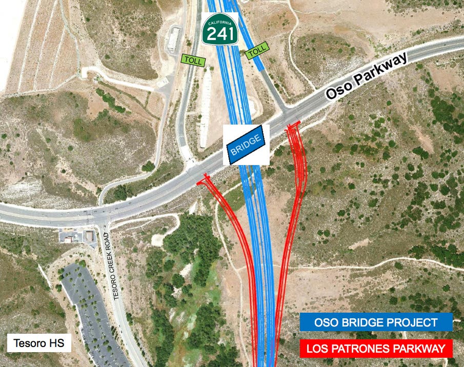
Toll Road Less than 100' from Tesoro High School
TCA is Completing the Tesoro Extension of the Toll Road in Pieces to Avoid Environmental Review
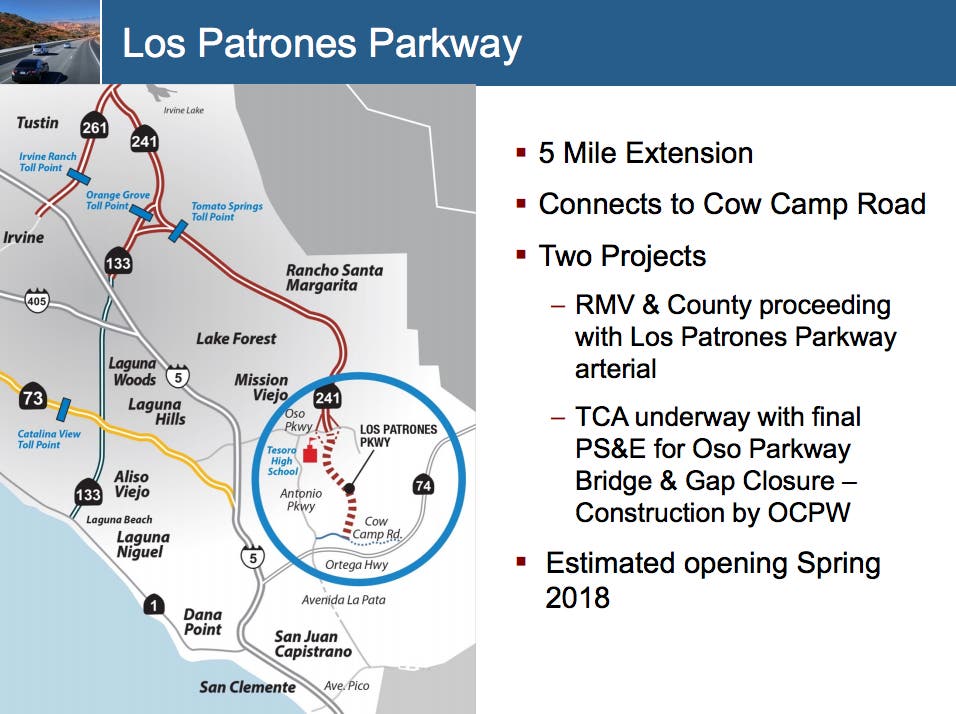
CUSDWatch: The TCA is completing the 241 South to Cow Camp Road in three pieces
The TCA is completing the 241 South to Cow Camp Road in three pieces:
- The Oso Bridge Project
- Los Patrones aka F Street
- The Oso Bridge Gap Closure

see: American Council of Engineering Companies Orange County Chapter March 22, 2017
The Current 401 Certification does not include the Gap Closure
The 401 Certification does not include the Oso Bridge Gap Closure- the current permit has Los Patrones aka F Street terminating at the Oso bridge. The Water Board gave them permission to grade a dead end basin at the Oso Bridge.
Source: 401 Certification RMV "F" Street from "A" Street to Oso Parkway Project Certification No R9-2014-0144
Find out what's happening in San Juan Capistranofor free with the latest updates from Patch.
Find out what's happening in San Juan Capistranofor free with the latest updates from Patch.
An application dated November 24, 2014 was submitted by Rancho Mission Viejo (RMV) (hereinafter Applicant), for Water Quality Certification pursuant to section 401 of the Clean Water Act (33 U.S.C. § 1341) for the proposed "F" Street from "A" Street to Oso Parkway Project (Project). The California Regional Water Quality Control Board, San Diego Region (San Diego Water Board) deemed the application to be complete on April 9, 2015. The Applicant proposes to discharge dredged or fill material to waters of the United States and/or State associated with construction activity at the Project site. The Applicant has also applied for a Clean Water Act section 404 permit from the United States Army Corps of Engineers for the Project (USACE File No. SPL-2015-00054).
The Project covered by this certification is located at Rancho Mission Viejo, east of Interstate 5, and north of San Juan Creek, at 28811 Ortega Highway, in the City of San Juan Capistrano, Orange County, California. The Project center reading is located at latitude 33.562901 and longitude -117.609571 . The Applicant has paid all required fees for this Certification in the amount of $40,703. On April 9, 2015, the San Diego Water Board provided public notice of the Project application pursuant to California Code of Regulations, title 23, section 3858 by posting information describing the Project on the San Diego Water Board's web site and providing a period of twenty-one days for public review and comment. No comments were received.
Note: No Comments were received because the application was approved ADMINISTRATIVELY by the County of Orange and the Public in Orange County wouldn't think to look at the San Diego Water Board web site for any notices.
The Applicant proposes to construct a new County of Orange arterial road called "F" Street that will extend approximately 5.5 miles from Cow Camp Road north to Oso Parkway, at the current terminus of State Route-241 (SR-241 ). In the future, "F" Street will be renamed to Los Patrones Parkway. "F" Street is not the Tesoro Extension of SR-241 that was denied waste discharge requirements by the San Diego Water Board in 2013 (in the proceedings on Tentative Order No. R9-2013-0007) or a facility related to the SR-241 and the Tesoro Extension is not covered by this Certification. "F" Street will be operated by the County of Orange as a free road . "F" Street is proposed to be a County of Orange Rural Secondary Highway, modified to include a raised median and a future community trail on the west side. "F" Street supports development of the Applicant's Planning Area 2 and Planning Area 3 projects, provides an alternate route to Antonio Parkway, and improves vehicle throughput to the SR-241 . On June 24, 2014, the Orange County Board of Supervisors approved an agreement for Grant of Fee Credits with the Applicant, which will allow the County to grant fee credits to the Applicant and accept the road right-of-way and improvements if the Applicant constructs "F" Street.
As a modified Rural Secondary Highway, the roadway will consist of two twelve-foot through lanes, eight-foot shoulders in both directions, and a fixed median between approximately stations 1 05+00 and 230+00 that is 1 0-11 feet wide and widens to accommodate connections to "A" Street and Oso Parkway. South of "A" Street the median is up to 58 feet wide. "F" Street will have a design speed of 70 mph and a posted speed limit of 65 mph. This is consistent with the approved Letter of Geometric Alignment Recommendation and Geometric Approval Drawing referenced in the above-mentioned Fee Credit Agreement. At its northern terminus, "F" Street will connect to Oso Parkway at the at-grade existing intersections of the on and off-ramps from the SR-241. Local access to the north end of the Applicant's Planning Area 2 project from "F" Street will be via "A" Street, with access to "A" Street provided via a grade separated half-expressway-interchange, with access to and from the north. At its southern terminus, "F" Street will terminate at Cow Camp Road as an at-grade signalized the intersection.
A portion of "F" Street, within the footprint of the Planning Area 2 project, was previously permitted under United States Army Corps of Engineers (USAGE) Section 404 Permit SPL2013-00126-JPL, San Diego Water Board section 401 Water Quality Certification No. R9- 2013-0036, and California Department of Fish and Wildlife (CDFW) Streambed Alteration Agreement No. 1600-2006-0438-0006-R5. The "F" Street Project is a Covered Activity under the San Juan Creek/Western San Mateo Creek Watershed Special Area Management Plan (SAMP) issued by the USAGE and Master Streambed Alteration Agreement (MSAA) issued by CDFW. It should be noted however that the current design has a different alignment than permitted in the SAMP and MSAA, includes multi-modal facilities (i.e., a trail), and has a different connection to Oso Parkway (direct connection to Oso Parkway instead of via Tesoro Creek Road).