Community Corner
Beating the Heat at the Bridge to Nowhere
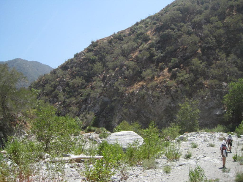
This week's hike in the San Gabriels takes us along the East Fork River 5 miles to the Bridge to Nowhere, a bizarre monument left over from the early half of the 20th century.


It was in the low 100’s in parts of the San Gabriel valley this past Thursday. In order to beat the heat but still be outside, I ventured out to the East Fork of the San Gabriel River to hike to the Bridge to Nowhere with my friends Cathy and Brian.
This is a unique hike unlike any other in the San Gabriels. There are multiple river crossings where the water can be as high as 3 or 4 feet.
There are also a couple of spots where a little bit of scrambling up rocks is necessary, though it is pretty easy with a bit of concentration. In addition, prospectors pan for gold throughout the river and there are times where you will see pieces of silver lining the trail.
Find out what's happening in Sierra Madrefor free with the latest updates from Patch.
We arrived at the East Fork/Coyote Flat parking lot at 9:00 a.m. and the temperature was already over 90 degrees. Fortunately, after an easy mile of hiking, we reached our first water crossing. The cool, knee-deep water provided instant relief. Shortly after the first water crossing, we came upon a section of trail that seemed to have been damaged from this past winter. Instead of climbing up the sketchy rock, we simply hiked down to the river and waded around this obstacle.
Further on ahead, the trail remains flat and ventures away from the river and through some prairie-like terrain. This area definitely felt very hot and, at one point, Brian’s thermometer read 104 degrees. However, we plodded along on our journey and soon enough found ourselves at more cool river crossings.
Find out what's happening in Sierra Madrefor free with the latest updates from Patch.
Three miles in, a section of the trail was destroyed recently and we rerouted our trip down into the water with ease. After walking through the shallow river for half a mile, we, once again, met up with the trail (as denoted by a large rock arrow), and we continued on to our final destination: the Bridge to Nowhere.
Cathy, Brian, and myself marveled at the weird landmark – a reminder of a road construction project that was abandoned in the late 1930’s. As if the bridge wasn’t enough of a reward for our hiking efforts, we spotted two separate herds of bighorn sheep meandering along the adjacent cliffs. This capped off a very fun and surreal hike for our trio in a very unique canyon.
Hike At A Glance
Difficulty Level (1-10): 6 – This hike is mostly flat but requires some concentration on where and when the best spots are to cross the river. As a rule of thumb, the wider the river is in a spot, the easier it will be to cross.
Distance: around 10 miles roundtrip
Scenery: This hike is entirely in a canyon. There are some wonderful natural rock formations and some scenic pools of water, especially around the bridge. The Bridge to Nowhere is also a site unlike any other.
Best time to go: Summer and early fall are best. The river swells from snowmelt and is also very cold in the winter and that can lead to very dangerous conditions. Be cognoscente of the river conditions and don’t take chances.
Trail condition: The trail can be tricky to follow at times, but because this is in a canyon, it’s pretty hard to get lost. Be careful when fording the river. Trekking poles will definitely help you get across. Also try to limit how much scrambling you do on the rocks. Some of the scrambling parts are a bit slick and wading through the river around these parts is often a better and safer (and cooler!) idea.
Other considerations:
- Just like anywhere in the San Gabriel Mountains, be mindful of typical hiking hazards like bees and ticks. This area is infamous for rattlesnakes so be sure to leash your dogs and keep your eyes peeled.
- Dry bags are recommended for this hike to keep the contents of your backpack dry (especially electronics).
- Make sure to bring enough water or a filter to create drinkable water from the river. I personally used a Katadyn MyBottle filter and was very happy with how it worked.
- Footwear is important to consider for all hikes, but especially this one. I recommend merino wool socks and a pair of hiking shoes that ventilate well (no waterproof shoes!). I don’t recommend wearing cotton anything on this hike.
- At the parking lot, if they're available, fill out a permit to enter into the Sheep Wilderness.
Getting there: Take the 210 to Azusa Ave/39. Travel north on 39 to East Fork Road. Turn right and take East Fork Road to the parking lot it ends at. Make sure you have an Adventure Pass displayed in your vehicle ($5 per day or $30 per year, available at REI or most other sporting stores).