Community Corner
Floating Around in the Devil’s Punch Bowl
This week's hike takes us into the Devil's Punch Bowl County Park, a distinctive area known for its unusual rock formations, vistas and vast array of flora and fauna.


The Devil’s Punch Bowl County Park is a wonderful spot to spend a morning, afternoon, or even a night. Located on the San Andreas Fault at the northern edge of the San Gabriel Mountains, the Devil’s Punch Bowl offers a plethora of scenic rock formations, flora, and fauna.
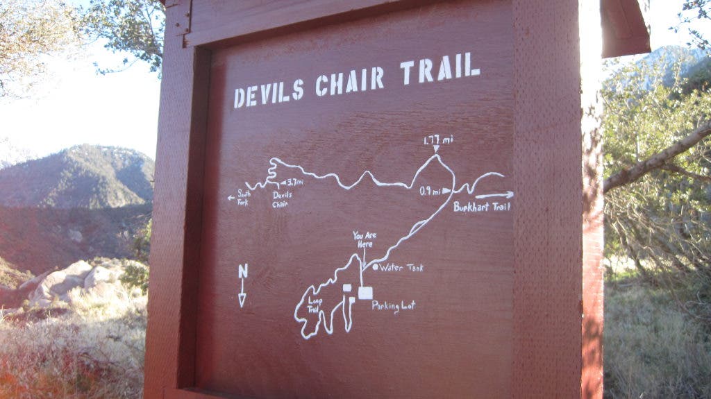
Recently, my friends Jerry, Aaron and Victor drove out to the Punch Bowl to enjoy a moderate day hike. We set parked one car in the lot for the ranger station and drove out in another car to the South Fork Campground area. Upon exiting the car, we were greeted by the desert heat of the midday. Of course, we expected this, being that the Devil’s Punch Bowl is located on the southern edge of the Mojave Desert.
We crossed the South Fork, a gently running creek, and began a trek up a well-established foot trail. We passed common chaparral and Manzanita, but enjoyed the unusually soft dirt trail. The trail wound to-and-fro, around multiple small hills, and led us up to a wondrous north-facing ledge trail.
Find out what's happening in Sierra Madrefor free with the latest updates from Patch.
After four miles, we reached Devil’s Chair, a bizarre peninsula of sandstone that overlooks the entire surrounding punch bowl. Here, we took a deserved break to indulge in Cliff Bars, sandwiches, and electrolyte drinks. After our lunch stop, we continued onward, up the path into an unexpected subalpine microclimate that featured pine trees and more squirrels than I have ever witnessed in the San Gabriels. This stretch of trail was fairly level and not difficult at all to hike on.
Finally, at around six miles in, the trail sloped downward and brought us down a comfortable two-mile descent. We passed through more common deciduous terrain and eventually reached a road. This dirt road was covered in mountain lion and bear tracks. We followed the road for a short distance, back to our car shuttle in the ranger station lot, and we drove home, capping off another fun hike in the San Gabriels.
Find out what's happening in Sierra Madrefor free with the latest updates from Patch.
Hike At A Glance
Difficulty Level (1-10): 5
Distance: 8 miles (with a car shuttle)
Scenery: The view varies greatly; this hike features views of subalpine terrain, desert terrain, and deciduous forest.
Best time to go: Year-round. The Punchbowl can get very hot in the summer and accumulates snow in the winter. Prepare accordingly (and bring lots of water!).
Trail condition: This trail is easy enough to follow.
Other considerations: There are other hikes that meet up in the Devil’s Punchbowl, including the South Fork Trail from Islip Saddle. Many people will combine this hike with longer ones. Also, just like anywhere in the San Gabriel Mountains, be mindful of typical hiking hazards like bees, snakes, bears, mountain lions, and ticks.
Getting there: The best way to get to the Devil’s Punchbowl is to take Angeles Crest Highway/SR 2 north to Angeles Forest Highway. Follow AFH north to Mount Emma Road and turn right. Take that road to where it ends at Fort Tejon Road and turn right/east. Take that to Longview Road/Devil’s Punch Bowl Road and turn right/south. From there, the ranger station should be fairly easy to find. This website also has a helpful and free map: http://www.devils-punchbowl.com/ Be sure to hang your Adventure Pass in your parked vehicle (available for $5 for a day or $30 for a year at REI or any other sporting store in the area).