Community Corner
Hiking in the High Altitude of Mount Whitney
This week's hike chronicles Mount Whitney, the largest mountain in the contiguous 48 states. Mount Whitney hosts many diverse landscapes, many of which are similar to our local mountains.


Hello, my name is Matthew and I am addicted to peak-bagging.
My addiction almost got me seriously injured on Tuesday.
I received my much sought after permit for hiking Mount Whitney, the tallest mountain in the contiguous 48 states, in April. The thought of reaching the summit of Mount Whitney, one of the most popular California mountains, has consumed me over the last three months.
Find out what's happening in Sierra Madrefor free with the latest updates from Patch.
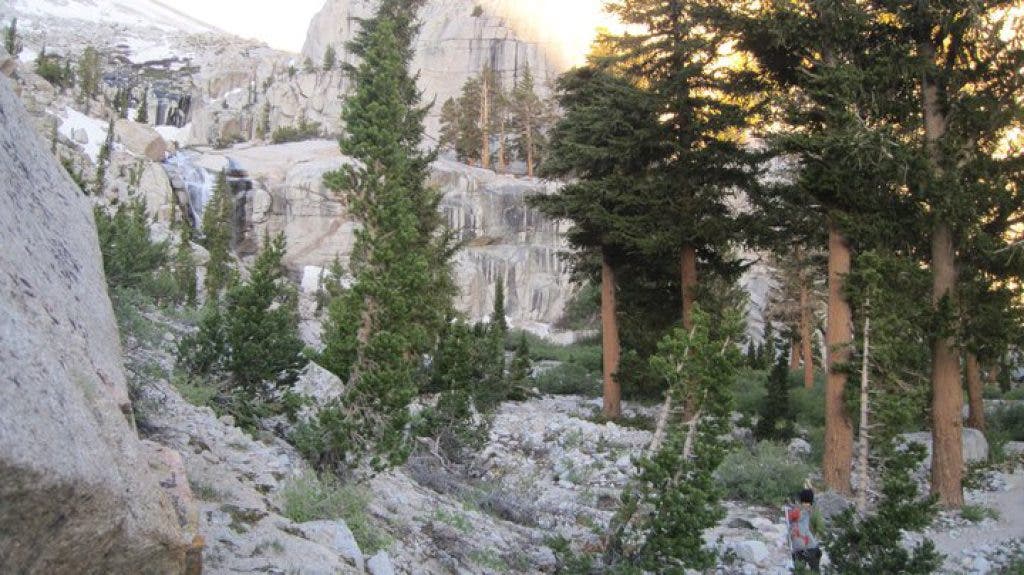
Along with my two fellow hikers, Victor and Casey, I drove up to the Mount Whitney Portal (trailhead) on Monday afternoon. Our plan was to acclimatize to the elevation of Whitney by camping at the 8500’ trailhead. The sheer beauty of the flora and fauna of Mount Whitney Portal was invigorating and reminded me of our local hotspot, Icehouse Canyon. We consumed high amounts of calories and electrolytes and went to sleep early Monday night.
Tuesday morning at 3:31 a.m., we began our headlamp-assisted hike along a well-groomed trail that switchbacks through gorgeous Jeffrey Pine trees. We weaved our way around and across intense water crossings that were reminiscent of some crossings in Devil’s Canyon. After 2.5 miles or so, we reached Lone Pine Lake, a beautiful body of water that is tucked away amidst the subalpine landscapes of the Sierra Nevada Mountains. The faint glow of the rising sun illuminated this lake, just as a candle lights up a room.
Find out what's happening in Sierra Madrefor free with the latest updates from Patch.
Shortly after Lone Pine Lake, we came across meadow-saddled Outpost Camp, the first campground on the trail. We were steadily climbing in elevation and I began to feel some of those effects: A slight headache began to claw at the insides of my skull and my appetite became maniacally distracting. I took note of this and continued onward, while continuing my high intake of food and water.
Upward we ascended: 10,000 feet like Mount Baldy… 10,500 feet… 11,000 feet… and 11,500 feet. My body’s condition further deteriorated as we increased our elevation; soon, I was hyperventilating, seeing brown spots, and exhibiting an incredible amount of fatigue. We took an extended break next to Consultation Lake, a half-frozen body of water that mirrored its surrounding landscape much in a way similar to Crystal Lake. The break helped but my body continued to resist.
Finally, we reached Trail Camp, the last campground before the 4 mile ascent to the summit of Mount Whitney. Here, my body instinctively sat down. I felt myself losing control of my physical condition and my friends verified those feelings with their own observations. I was showing the symptoms of acute mountain sickness, a potentially dangerous condition, and my coughing increased dramatically. Trail Camp, in its 12,000-foot high splendor, would be the pinnacle of the day’s journey.
I felt extremely disappointed in myself. I have reached the summits of dozens of mountains in California over the last 2.5 years and I take pride in that. Turning around 4 miles before the Whitney summit left me feeling incomplete. My friend Casey, however, repeatedly pointed out that Mount Whitney will be there tomorrow. And the day after. And the year after that. And the decade after that. Casey inspired an appreciation within me for, not just the summit of the mountain, but the journey along the trail leading to the summit. When it was all said and done, our trio enjoyed a 14-mile hike among magnificent alpine landscapes and great conversations – and that is a pretty wonderful day.
Hike At A Glance:
Difficulty (1-10):
9
Distance
14 miles roundtrip if turning around at Trail Camp. 22 miles roundtrip if hiking to the summit.
Scenery
This trail winds through multiple sets of switchbacks and includes journeys across creeks, melting snow drifts, meadows, and alpine landscapes.
Best time to go:
For casual hiking, go in summer or early fall and try not to hike during the afternoon (to avoid thunderstorms). You can travel this during the winter if you have plenty of winter mountaineering experience and gear.
Trail condition:
This trail is very easy to follow but does include a good amount of loose scree.
Other considerations:
There were two small spots where a few flies were out, but otherwise they were a non-factor. As always, in the mountains, watch out for bugs, snakes, bears, and other wildlife. Also, a permit is required for this hike. Call the Eastern Sierra Interagency Visitor Center at (760) 876-6200 for specifics on permits.
Getting there:
The Whitney Portal Campground is 10 minutes east of Lone Pine, CA, in the eastern Sierra Nevada Mountains.