Weather
'Atmospheric River' To Dump Heavy Rain On Temecula
Weather Service officials say a "very wet storm system" is bringing rain to the region.


TEMECULA, CA — Get those umbrellas ready again, more rain is coming to Temecula and it's expected to be heavy at times. The National Weather Service says a low-pressure storm system is expected to bring an "atmospheric river" with it to Riverside County Wednesday, bringing moderate to heavy showers as well as the potential for flash flooding and debris flows.
The inclement weather forecast prompted Riverside County officials to issue a voluntary evacuation order late Tuesday for select areas near the recent Holy Fire burn area.
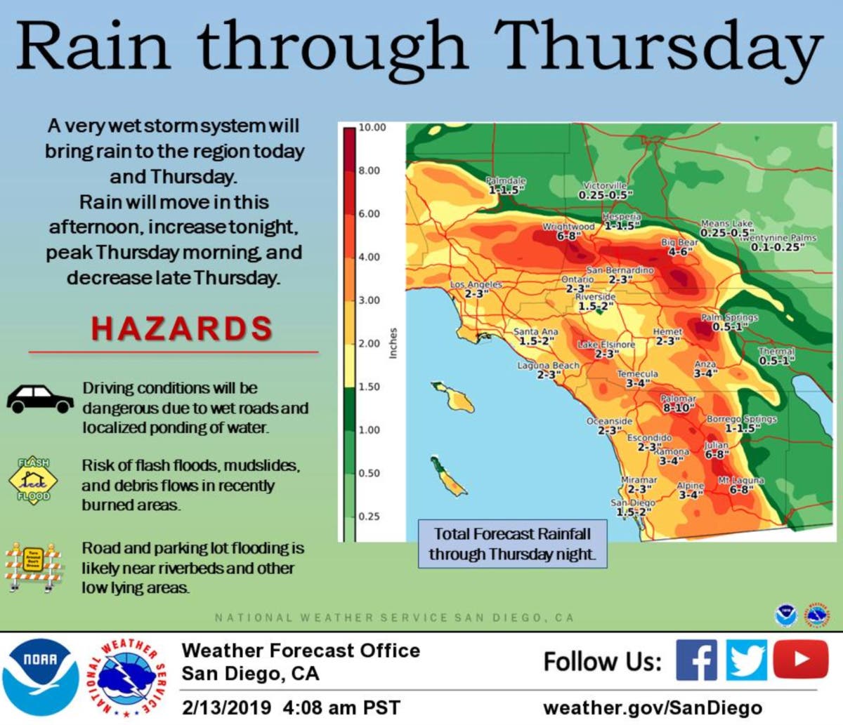
"Lighter rainfall will develop today and become more widespread this evening," the NWS said in its Wednesday morning forecast discussion. "The rainfall is expected to be heavy at times for late tonight through Thursday afternoon with the greatest rainfall on the coastal mountain slopes. There will also be strong gusty southwest to west winds in the mountains from this afternoon into Thursday evening."
Find out what's happening in Temeculafor free with the latest updates from Patch.
Snow levels are also expected to lower, but are expected to remain above 9,000 feet.
All this talk of an #AtmosphericRiver. Here's what it looks like from outer space Notice the moisture plume take aim at California. #cawx #castorm pic.twitter.com/71J3uCQzJ2
— NWS Bay Area (@NWSBayArea) February 13, 2019
The NWS issued a flash flood watch for the Riverside County mountains, valleys and the San Gorgonio Pass near Banning that will be in effect from late Wednesday evening through Thursday evening. A high wind warning will also be in effect in the county mountains from noon Wednesday through 10 p.m. Thursday.fThe Coachella Valley was not included in either advisory.
Find out what's happening in Temeculafor free with the latest updates from Patch.
The Riverside metropolitan area and Lake Elsinore are forecast to get up to four-tenths of an inch of rainfall Wednesday, while up to six-tenths of an inch is expected in the San Gorgonio Pass near Banning and the Coachella Valley will receive around one-tenth of an inch, forecasters said. Idyllwild and Pine Cove could get up to 2 inches of rainfall Wednesday.
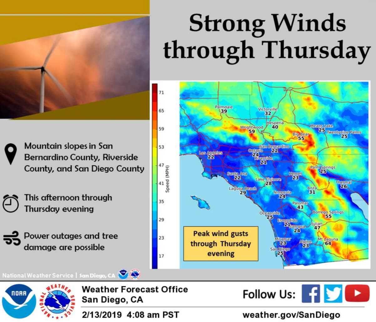
South to southwest winds of 25 to 40 mph, with gusts reaching 65 mph, are expected Wednesday afternoon through Thursday evening, according to the NWS.
As for Temecula in particular, here's what the National Weather Service says residents can expect for the next few days:
Wednesday
Rain, mainly after 10am. High near 59. Southwest wind 5 to 10 mph. Chance of precipitation is 80%. New precipitation amounts between a tenth and quarter of an inch possible.
Wednesday Night
Rain. The rain could be heavy at times. Low around 51. South wind around 5 mph. Chance of precipitation is 100%. New precipitation amounts between three quarters and one inch possible.
Thursday
Rain. The rain could be heavy at times. High near 58. South wind 10 to 15 mph, with gusts as high as 25 mph. Chance of precipitation is 100%. New precipitation amounts between 2 and 3 inches possible.
Thursday Night
Showers likely, mainly before 10pm. Mostly cloudy, with a low around 47. Southwest wind 5 to 10 mph, with gusts as high as 20 mph. Chance of precipitation is 70%. New precipitation amounts between a tenth and quarter of an inch possible.
Friday
A chance of showers. Partly sunny, with a high near 56. West wind 5 to 15 mph, with gusts as high as 20 mph. Chance of precipitation is 30%. New precipitation amounts of less than a tenth of an inch possible.
Friday Night
A chance of showers. Mostly cloudy, with a low around 43. Chance of precipitation is 40%.
The Riverside County Emergency Management Department issued voluntary evacuation orders for the following neighborhoods near the Holy Fire burn area: Amorose, Alberhill, Alvarado-A, Glen Eden, Glen Ivy-A, Glen Ivy-B, Grace, Horsethief-A, Laguna-A, Lakeside-A, Maitri, McVicker-A, Rice and Withrow-A.
The EMD also advised residents near the Cranston burn area, which blackened just over 13,000 acres between Hemet and Idyllwild, to prepare for potential evacuation orders by arranging transportation, putting fuel in cars and making plans to care for animals.
County officials urged residents to check maps at www.RivCoReady.org/StormReady to determine if they are in an evacuation area. Residents can also sign up for emergency alert notifications via the website.
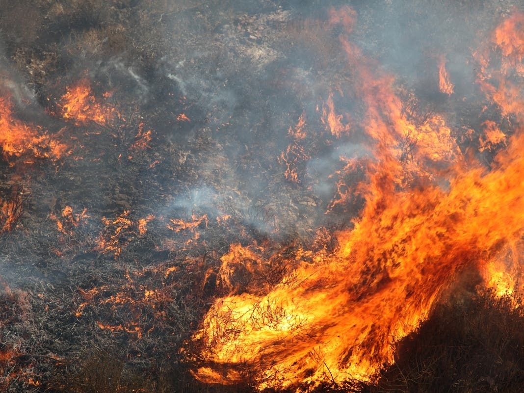
A wide area skirting the eastern boundary of the national forest, including Lake Elsinore and the Temescal Valley, was left exposed to potential flood damage because of the 23,000-acre Holy Fire in August. The blaze, allegedly the work of an arsonist, denuded steep terrain below Santiago Peak, permitting water to flow unchecked onto lower slopes where subdivisions are situated.
During a three-part storm series between Jan. 31 and Feb. 4, the EMD issued mandatory evacuation orders covering the Glen Ivy, Horsethief Canyon and McVicker Park communities on the north side of Lake Elsinore and south of El Cerrito, along Interstate 15.
Mud and debris flows prompted several street closures, but no significant damage was reported in connection with the storms.
The storm will die down significantly late Thursday afternoon and scattered showers are expected to continue through Monday afternoon, Miller said.
— City News Service contributed to this report / Image via Shutterstock
Get more local news delivered straight to your inbox. Sign up for free Patch newsletters and alerts.