Weather
Heavy Rain, Chance Of Snow In Mountains Near Temecula Forecast
Get your umbrellas out... and possibly plan a trip to see some snow.


RIVERSIDE COUNTY, CA — A storm system expected to roll in Friday evening will bring rain to the Inland Empire and could dump snow in some parts of the Riverside and San Bernardino county mountains, though it was still too early Friday morning to tell whether flooding might occur, particularly in burn-scarred areas, forecasters said.
The south-moving storm will begin dousing the region late Friday evening or early Saturday morning and continue through Saturday evening, according to the National Weather Service.
The Riverside metropolitan area and Lake Elsinore are expected to get up to a half-inch of rainfall over the weekend, while around four-tenths of an inch of rain is expected in the San Gorgonio Pass near Banning, and the Coachella Valley could get around two-tenths of an inch, meteorologists said.
Find out what's happening in Temeculafor free with the latest updates from Patch.

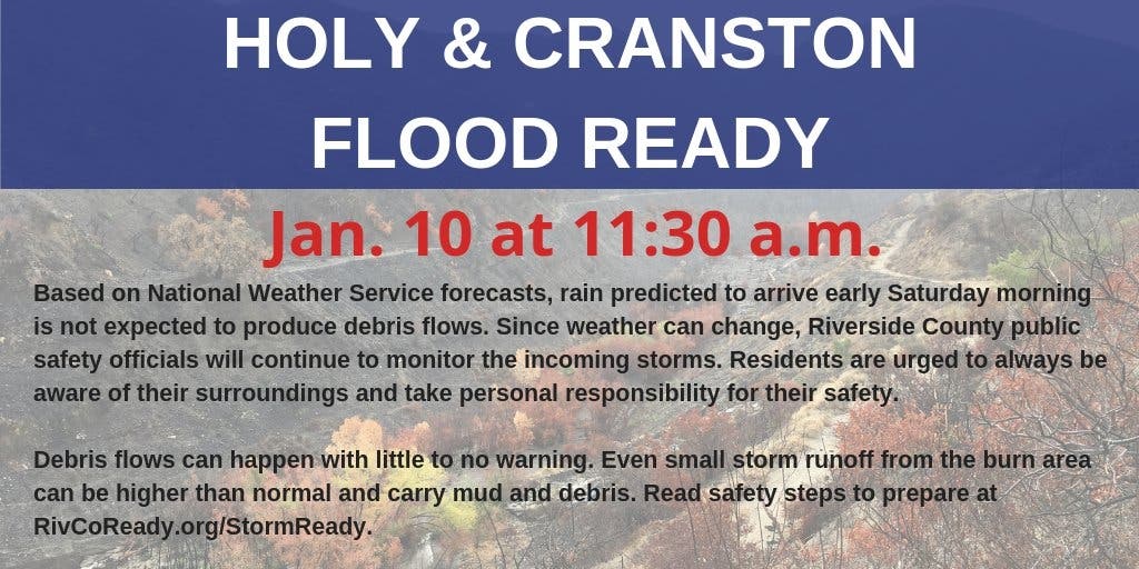
Officials with the county's emergency management department said those living in the Holy and Cranston fire burn scars should be prepared as "even small storm runoff from the burn area can be higher than normal and carry mud and debris."
However, as of Friday morning, officials were optimistic that the areas would not be in danger. The low-impact rain event makes it unlikely that flooding, mud and debris flows will develop around the Cleveland National Forest and communities near the foot of the Lake Matthews Estelle Mountain Reserve, including Lake Elsinore and the Temescal Valley.
Find out what's happening in Temeculafor free with the latest updates from Patch.
"Based on National Weather Service forecasts, rain predicted to arrive early Saturday morning is not expected to produce debris flows," the county said. "Since weather can change, Riverside County public safety officials will continue to monitor the incoming storms. Residents are urged to always be aware of their surroundings and take personal responsibility for their safety."
The NWS issued a dense fog advisory for the Riverside County valleys that is set to last until 9 a.m. Friday.
The weather service also issued a winter weather advisory for the San Bernardino County Mountains set to expire at 6 p.m. Saturday, with snow levels expected to drop to 5,500 feet.
As for Temecula in particular, here's the detailed NWS forecast for the coming days:
Friday
Areas of fog before 10am. Otherwise, mostly sunny, with a high near 64. Light and variable wind becoming southwest 5 to 10 mph in the afternoon.
Friday Night
A slight chance of rain before 10pm, then showers, mainly after 10pm. The rain could be heavy at times. Low around 46. Southwest wind around 5 mph becoming calm in the evening. Chance of precipitation is 80%. New precipitation amounts between a tenth and quarter of an inch possible.
Saturday
Showers, with thunderstorms also possible after 10am. Some of the storms could produce heavy rainfall. High near 54. East wind 5 to 10 mph becoming southwest in the afternoon. Chance of precipitation is 90%. New rainfall amounts between a quarter and half of an inch possible.
Saturday Night
A slight chance of showers. Mostly cloudy, with a low around 44. South wind around 5 mph becoming calm in the evening. Chance of precipitation is 20%.
Sunday
Partly sunny, with a high near 61. Northeast wind around 5 mph becoming south in the morning.
Sunday Night
Mostly cloudy, with a low around 45.
Monday
A chance of rain after 10am. Partly sunny, with a high near 60. Chance of precipitation is 40%.
Monday Night
Rain likely. Mostly cloudy, with a low around 48.
A series of weather systems will bring heavy rainfall, gusty winds, and high surf to California through next week. The wettest period will be Mon through Thursday. Flash flooding, and debris and mud flows will be possible, especially, around burn scars. pic.twitter.com/FGGDlRU6VN
— NWS (@NWS) January 11, 2019
Storm cells that crossed the area last week did not trigger any hazards, despite rainfall totals nearing an inch in some spots.
A wide area skirting the eastern boundary of the Cleveland National Forest was left exposed to potential flood and mud damage because of the 23,000- acre Holy Fire in August. The blaze, allegedly the work of an arsonist, denuded steep terrain below Santiago Peak, permitting water to flow unchecked onto lower slopes where subdivisions are situated.
Rains on Dec. 6 resulted in significant flooding and mud flows into several neighborhoods, prompting street closures and evacuations. However, there was no major damage to homes.
The storm system will move east out of the region by Sunday, but a separate system expected to bring multiple rounds of significant rain could sweep into the region beginning Monday or Tuesday, according to the NWS.
When precipitation is expected to result in storm-related hazards, the Emergency Management Department may issue voluntary evacuation orders. The agency posts mandatory orders when threats are confirmed.
More information is available at www.rivcoready.org.
— City News Service contributed to this report / Patch file photo by Renee Schiavone
Get more local news delivered straight to your inbox. Sign up for free Patch newsletters and alerts.