Community Corner
Nasa Photos Reveal Vast Destruction Left Behind From Ravaging Wildfires
"When disasters like this occur, we are able to swiftly respond to requests from our partners who need images and mapping data."
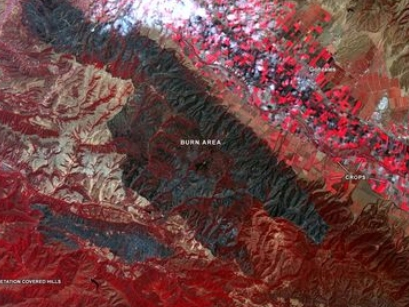
SAN FRANCISCO (CBS SF) — The wildfires that have raged through more than 1 million acres in Northern California since igniting during dry lightning strikes last month have left behind massive burn scars across the once green landscape.
Nowhere is this more evident than from space. NASA scientists have trained cameras from the Aqua and Terra satellites orbiting over the West Coast to capture images of the vast destruction.
Find out what's happening in Walnut Creekfor free with the latest updates from Patch.
As California experiences one of the worst wildfire seasons on record, we’re using our resources to help responding agencies. From air and space, we’re mapping the current fires, while identifying areas that may be susceptible to future risks. https://t.co/zGzIFFUhi2 pic.twitter.com/3Vwdon2hvV
— NASA JPL (@NASAJPL) September 1, 2020
This image of MODIS, dated August 26, on NASA's Terra Satellite, shows large burn scars (brown areas) and fire detections (red marks). #cawx pic.twitter.com/eosC9ALDXb
— NWS Bay Area (@NWSBayArea) August 31, 2020
Read more at CBS San Francisco