Weather
CT Eyes 2 Storms As Hurricane Season Nears Peak
Tropical Storm Gordon and Hurricane Florence both pose threats.

As peak hurricane season approaches, Connecticut is about to be drenched by the remnants of Tropical Storm Gordon and forecasters are warily watching another storm making its way across the Atlantic.
And they predict another two to three storms could form before the weekend.
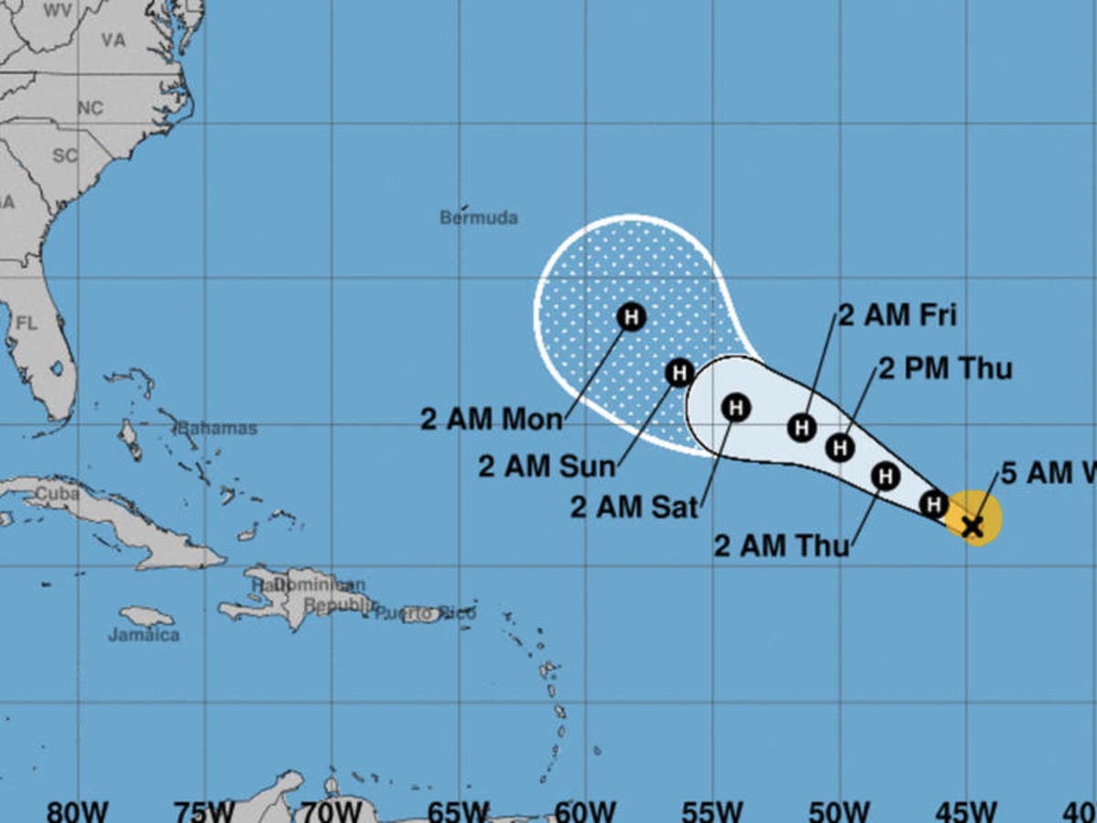
Hurricane Florence, though nowhere near land on Wednesday, could be headed towards Bermuda and, from there, possibly towards the Northeast, according to AccuWeather .
Find out what's happening in Across Connecticutfor free with the latest updates from Patch.
"There is concern that Florence may get steered closer to Bermuda around Monday, Sept. 10 — the peak of hurricane season in the Atlantic," AccuWeather meteorologist Kristina Pydynowski said.
"After nearing Bermuda, Florence may attempt to approach the eastern United States later that week," though Pydynowski added it was far too early to accurately predict the storm's path.
Find out what's happening in Across Connecticutfor free with the latest updates from Patch.
Tropical Storm Gordon made landfall in Mississippi Tuesday night, battering the area with heavy rain and brutal winds. It's expected to now make it's way north and east.
Though it will be greatly weakened, the remnants of the storm are expected to hit the northeast early next week, with up to four inches of rain expected to fall within a 12 to 24 hour period, AccuWeather said. (To sign up for free, local breaking news alerts from more than 100 Connecticut communities, click here.)

Mid-September is considered the height of the Atlantic hurricane season, and AccuWeather is expecting activity to pick up this week.
"At this point of the hurricane season, ocean water temperatures in the tropical Atlantic are at their warmest point, while disturbances, known as tropical waves, roll frequently westward off the coast of Africa," said AccuWeather meteorologist Alex Sosnowski.
"Indications are that two to three new tropical systems may bud and develop in the eastern and central Atlantic this weekend into next week."
Very concerning shift in the EPS ensemble guidance with Hurricane #Florence ... must now seriously consider this storm a U.S. landfall threat. Still considerable uncertainty about a possible / hopeful turn away from the coast out to sea. Continue to monitor thru the weekend. pic.twitter.com/m692qfL48s
— Ryan Maue | weathermodels.com (@RyanMaue) September 5, 2018
Here's the detailed forecast, courtesy of the National Weather Service:
Today
Mostly sunny, with a high near 85. Light and variable wind becoming south 5 to 7 mph in the morning.
Tonight
Patchy fog after 2am. Otherwise, partly cloudy, with a low around 74. South wind 5 to 8 mph.
Thursday
A 40 percent chance of showers and thunderstorms after noon. Patchy fog before 8am. Otherwise, mostly sunny, with a high near 89. Heat index values as high as 96. Southwest wind 6 to 8 mph.
Thursday Night
A chance of showers and thunderstorms. Mostly cloudy, with a low around 70. Calm wind becoming northeast 5 to 8 mph after midnight. Chance of precipitation is 50%.
Friday
A 20 percent chance of rain before 9am. Mostly cloudy, with a high near 78. Northeast wind 7 to 10 mph.
Friday Night
Mostly cloudy, with a low around 63.
Saturday
Partly sunny, with a high near 75.
Saturday Night
Mostly cloudy, with a low around 59.
Sunday
Partly sunny, with a high near 70.
Sunday Night
A 30 percent chance of rain. Mostly cloudy, with a low around 60.
Monday
A 40 percent chance of showers and thunderstorms. Mostly cloudy, with a high near 74.
Monday Night
A 50 percent chance of showers and thunderstorms. Mostly cloudy, with a low around 65.
Tuesday
A 40 percent chance of showers and thunderstorms. Mostly cloudy, with a high near 79.
Written by Adam Nichols, Patch National Staff.
Lead image via the National Hurricane Center
Get more local news delivered straight to your inbox. Sign up for free Patch newsletters and alerts.


