Weather
CT Weather: Severe Storms Sunday, Isaias Arrives Tuesday
All eyes are on Tropical Storm Isaias and its potential impacts to Connecticut but strong-to-severe thunderstorms are possible Sunday.

CONNECTICUT — Most of the attention on the weather forecast has been centered on Tropical Storm Isaias and what impact it may have on Connecticut early next week.
The exact track of the storm remains unknown but the current thinking is that the entire state will see impacts. Isaias has weakened from a category one hurricane to a tropical storm Saturday afternoon but it is expected to reform as a hurricane early Sunday, according to the National Hurricane Center.
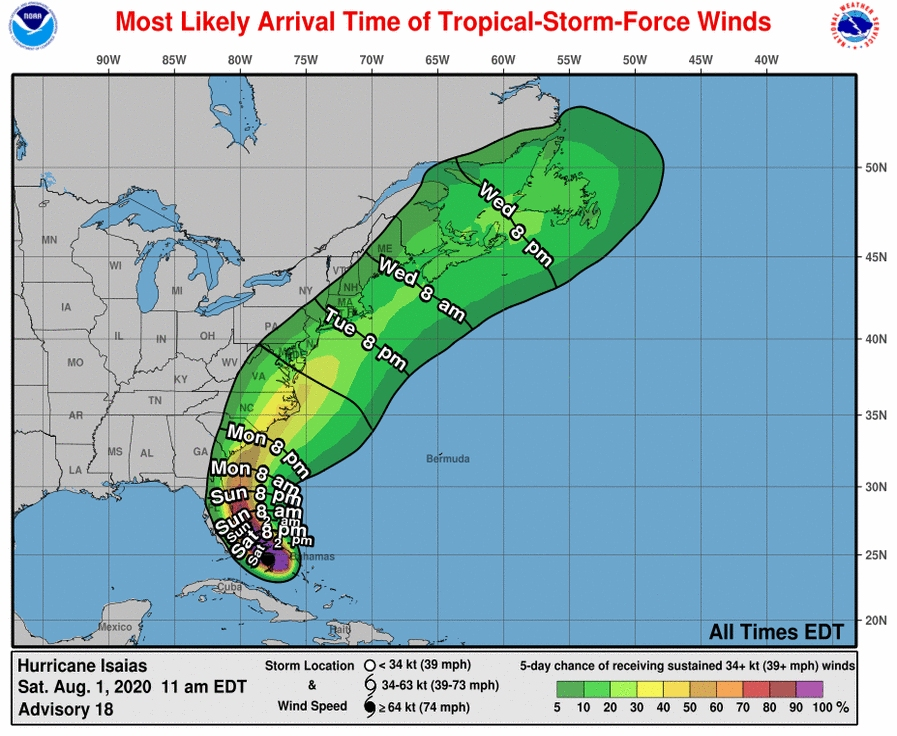
The National Weather Service said the current track takes Isais, or what remains of Isais, over Long Island and Connecticut.
Find out what's happening in Across Connecticutfor free with the latest updates from Patch.
"Up to 20% chance of tropical storm winds most likely arriving (Tuesday) evening, but may arrive as early as (Tuesday) morning. 2"-4" of rain is forecast, with 4"-6" possible inland. Locally heavier amounts possible," the National Weather Service's New York Office said.
The storm before the bigger storm
Find out what's happening in Across Connecticutfor free with the latest updates from Patch.
The National Weather Service has issued a hazardous weather outlook for southern Connecticut on Sunday for the chance for "severe thunderstorm development."
"There is a chance for severe thunderstorm development on Sunday. Damaging winds and hail are possible, even an isolated tornado," the weather service said.
Heavy rain and downpours are possible Sunday afternoon.
"Late Sunday afternoon into the evening shows some potential for strong to severe thunderstorms along the cold front as the low moves off to the northeast," the weather service said.
The lower Hudson Valley may see the most severe storms on Sunday, possibly an isolated tornado, according to the weather service.
For northern sections of the state, the weather service said on Sunday there may be a chance of showers after 5 p.m. and a chance for both showers and thunderstorms up until midnight. Winds will increase to 20 mph.
The weather service said there is a "low risk for a few severe thunderstorms across western MA and northern CT later Sunday afternoon and evening."
More details on Isaias' potential impact to CT
The weather service said for southern Connecticut the "potential impacts during the Monday night to Wednesday time period include heavy rainfall and tropical storm force winds, coastal flooding, and hazardous surf."
Heavy rain may move into southern Connecticut late Monday into Tuesday, the weather service said.
"It`s still too early to provide much in the way of specific details with the track and intensity uncertain, but the storm should be closely monitored," the weather service said concerning southern Connecticut.
The weather service said to expect heavy rain all day Tuesday and it will taper off on Wednesday though there may be some storms too.
Concerning northern parts of the state and the impact Isaias may have, the National Weather Service's Boston Office said, "The main focus for impactful weather will be early Tuesday through Wednesday."
"...there remains a high degree of uncertainty as to the track and timing of the system," the weather service said concerning northern parts of Connecticut. "Even a small shift in track will have a large impact on who sees what, rain and wind wise. The track will also have a large impact the strength of the storm."
The weather service said for northern areas of the state heavy rain, two inches or more, is possible on Tuesday.
"Please continue to monitor the latest forecasts from the National Hurricane Center in regards to Hurricane Isaias and its potential impacts in Southern New England. Our region remains in the cone of uncertainty Tuesday into early Wednesday," the weather service said of northern Connecticut.
Fox 61 Meteorologist Sam Sampieri said "So latest NHC Guidance has shifted about 40-50 miles west from Groton to Bridgeport/Stratford/Milford. Models matching up over CT for now.. Storm has weakened but, will re-strengthen overnight to a Hurricane before hitting Florida tomorrow."
He said the heaviest rain is now forecast for the I-84 and I-91 corridor in Connecticut.
See also: 2 Affluent Connecticut Towns Deal With Coronavirus 'Party Zero'-Type Cases
Get more local news delivered straight to your inbox. Sign up for free Patch newsletters and alerts.


