Weather
CT Weather: Major Storm To Drop Up To 16 Inches Of Snow By Monday
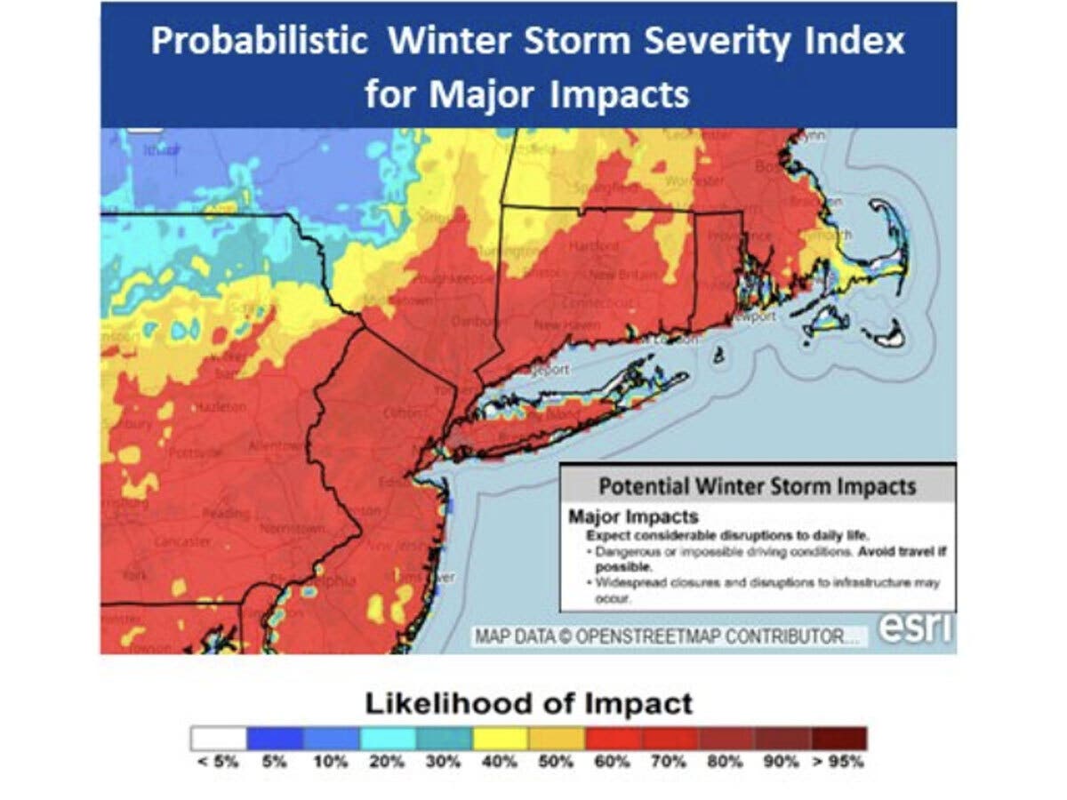
Local experts and the National Weather Service have released updated snow accumulation estimates and a winter storm watch has been issued.

The National Weather Service has issued a winter storm watch for the entire state of Connecticut as six inches or more of snow is forecast on Sunday and Monday.
Some sleet might mix in along the coast but everywhere should see a significant snow accumulation between 6 and 12 inches and possibly even more, meteorologists said.
Northern Connecticut forecast details
Find out what's happening in Across Connecticutfor free with the latest updates from Patch.
A winter storm watch has been issued from Sunday morning through Monday evening for Hartford, Tolland and Windham counties.
"Heavy snow possible. Potential for snow accumulations between 6 and 12 inches, with localized accumulations over 12 inches possible....Roads, and especially bridges and overpasses, will likely become slick and hazardous. Plan on slippery road conditions. The hazardous conditions could impact the Monday morning and evening commutes. Travel during the Monday morning commute is likely to be very difficult."
Find out what's happening in Across Connecticutfor free with the latest updates from Patch.
Southern Connecticut forecast details
A winter storm watch is in effect from late Saturday night through Monday afternoon for all of southern Connecticut.
"Heavy snow possible. Precipitation could mix with sleet and freezing rain for a time Sunday night especially closer to the coast. Potential for snow accumulation of 6 to 12 inches, with localized accumulations over 12 inches possible," the weather service said. "...Roads, and especially bridges and overpasses, will likely become slick and hazardous. Visibilities may drop below one quarter mile in heavy snow."
Litchfield County forecast details
And a winter storm watch is in effect from Sunday morning through Monday evening for Litchfield County as "greater than 7 inches possible."
Winter storm watch issued for entire forecast region for late Saturday night through Monday afternoon for heavy snow potential of 6 to 12 inches with some snow accumulations over 12 inches possible. See more here in this text product, https://t.co/iDiDwXWmTX. #NYwx #NJwx #CTwx pic.twitter.com/KgNCuZBFlw
— NWS New York NY (@NWSNewYorkNY) January 22, 2026
Other safety tips from the weather service
"Persons should consider delaying all travel from Sunday into Monday. If travel is absolutely necessary, drive with extreme caution. Make sure your car is winterized and in good working order. Consider taking a winter storm kit along with you, including such items as tire chains, booster cables, flashlight, shovel, blankets and extra clothing. Also take water, a first aid kit, and anything else that would help you survive in case you become stranded."
A Winter Storm Watch is in effect for all of Southern New England starting Sun AM through Monday PM. Confidence continues to increase that a winter storm will bring moderate to major impacts to the region with increasing probability of 12 inches of snow. #MAWX #CTWX #RIWX pic.twitter.com/9jRUErubXU
— NWS Boston (@NWSBoston) January 22, 2026
The local weather experts weigh in with their predictions
WTNH News 8 chief meteorologist Gil Simmons shared a snow forecast map, which shows up to 15 inches of snow in interior sections of the state and slightly less, up to a foot, at the coast due to the likelihood sleet will mix in.
"I expect the snow to start early in the morning through mid morning on Sunday and it will be heavy midday Sunday through the afternoon and evening....I do believe some sleet, you know those bouncing ice pellets will be mixing in along the shoreline at times into the late Sunday afternoon and evening hours, as some milder air gets in, so that will reduce the overall accumulation and it will make the snow heavier to move at the shoreline in that lower amount zone," Simmons wrote in a Facebook post. (Read more at News 8).
NBC Connecticut chief meteorologist Ryan Hanrahan shared a 12-minute video discussing the storm. You can watch it here. In his video, he said that 10 to 16 inches of snow is possible for much of southern New England. (Read more at NBC CT).
Fox 61 chief Meteorologist Rachel Frank wrote on Facebook "one thing to watch: a brief mix or sleet late Sunday/Sunday night, especially near the shoreline. That could keep snow totals slightly lower at the coast. Right now I’m thinking a range of 10”-15” should cover that uncertainty." She added that the heaviest snow is on Sunday afternoon and evening, and Monday is likely a snow day for students and staff. (Read more at Fox 61).
WFSB 3 TV meteorologist Tyler Hughes discussed the storm in an 11-minute video. You can watch that video here.
National Weather Service updates
The National Weather Service’s New York office reports the “significant winter storm” could cause “considerable disruption to transportation and daily life.”
It predicts the snow arrives early Sunday, with the heaviest snow later Sunday and into Sunday evening, with the storm winding down on Monday.
The probability of the state getting six inches or more of snowfall is higher than 85 percent, according to the latest forecast models, the National Weather Service reports.
“Confidence is increasing for a winter storm to impact the region Sunday through Monday,” the National Weather Service said. “A significant snowfall is possible. Uncertainty remains on track, timing and intensity of the storm system.”
Read More:
- Trump Issues Pardon To Convicted Felon: Here’s What You Need To Know
- Snowplow Driver Accused Of Being High On Cocaine During Crash Involving 2 Vehicles, Garage: Report
- ICE Arrests Man Inside Court
Here are the forecast details for southern Connecticut via the National Weather Service:
Tonight: Partly cloudy, with a low around 25. West wind around 7 mph.
Friday: Mostly sunny, with a high near 35. Wind chill values between 20 and 25. West wind 6 to 14 mph, with gusts as high as 24 mph.
Friday Night: Partly cloudy, with a low around 6. Wind chill values between -5 and zero. Northwest wind 8 to 10 mph, with gusts as high as 22 mph.
Saturday: Mostly sunny and cold, with a high near 17. Northwest wind 7 to 10 mph.
Saturday Night: A 40 percent chance of snow after 1am. Mostly cloudy, with a low around 8.
Sunday: Snow. High near 22. Chance of precipitation is 90%.
Sunday Night: Snow. Low around 15. Chance of precipitation is 80%.
Monday: A 40 percent chance of snow. Mostly cloudy, with a high near 26.
Monday Night: Partly cloudy, with a low around 10.
Tuesday: Mostly sunny, with a high near 25.
Tuesday Night: Mostly clear, with a low around 12.
Wednesday: Partly sunny, with a high near 27.
Here are the forecast details for northern Connecticut via the National Weather Service:
This Afternoon: Mostly sunny, with a high near 42. West wind 10 to 14 mph, with gusts as high as 24 mph.
Tonight: Partly cloudy, with a low around 19. West wind around 6 mph.
Friday: Mostly sunny, with a high near 32. Southwest wind 6 to 14 mph becoming west in the afternoon. Winds could gust as high as 28 mph.
Friday Night: Partly cloudy, with a low around 2. Wind chill values as low as -12. Northwest wind 10 to 14 mph, with gusts as high as 25 mph.
Saturday: Mostly sunny, with a high near 14. Northwest wind around 10 mph, with gusts as high as 23 mph.
Saturday Night: A chance of snow, mainly after 4am. Mostly cloudy, with a low around 5. Northwest wind 3 to 6 mph. Chance of precipitation is 30%. Little or no snow accumulation expected.
Sunday: Snow, mainly after 9am. The snow could be heavy at times. High near 20. Northeast wind 5 to 9 mph. Chance of precipitation is 90%.
Sunday Night: Snow. The snow could be heavy at times. Low around 14. North wind around 10 mph. Chance of precipitation is 100%.
Monday: Snow, mainly before 3pm. High near 23. North wind around 10 mph, with gusts as high as 20 mph. Chance of precipitation is 80%.
Monday Night: A chance of snow before 9pm. Mostly cloudy, with a low around 6. Northwest wind around 9 mph. Chance of precipitation is 30%.
Tuesday: Mostly sunny, with a high near 20. West wind 7 to 10 mph, with gusts as high as 20 mph.
Tuesday Night: Mostly clear, with a low around 3. West wind around 6 mph.
Wednesday: Mostly sunny, with a high near 24. West wind 5 to 8 mph.
Patch editor Brian McCready contributed to this story.
Get more local news delivered straight to your inbox. Sign up for free Patch newsletters and alerts.