Weather
Initial Snow Accumulation Estimates Released For CT’s Next Storm
Two prominent television stations have released snow accumulation estimates for the next storm system. Here's what you need to know.

Snow is predicted to fall in Connecticut on Friday evening and overnight, according to meteorologists.
WTNH’s forecast is for a strong cold front to come through on Friday, producing light snow Friday night and into early Saturday.
The station predicts a coating to two inches of snow will be possible. The precipitation will be accompanied by frigid temperatures, with highs only reaching up to 15 degrees, and wind chills of up to -35 and wind gusts reaching up to 50 miles per hour, according to WTNH.
Find out what's happening in Across Connecticutfor free with the latest updates from Patch.
WFSB reports cloud cover will increase in advance of a clipper system Friday.
“As it passes through the region there’s a chance for scattered/light snow at night, but as we see it now the impact will be minimal,” WFSB reports. “Data continues to fluctuate on how dry the air will be, hence how much moisture will be present for us to see much in the way of accumulation.”
Find out what's happening in Across Connecticutfor free with the latest updates from Patch.
Timeline for snow
It puts Friday night’s snowfall chance in the area of 30 to 40 percent, with the timing between 7 p.m. and 3 a.m.
For today through Thursday, daytime temperatures will reach the low 30s, and nighttime temperatures will dip into the teens, according to the National Weather Service. Friday’s daytime highs will reach the upper 20s. After that, expect significantly colder temperatures in the region, according to the National Weather Service.
Arctic outbreak this weekend
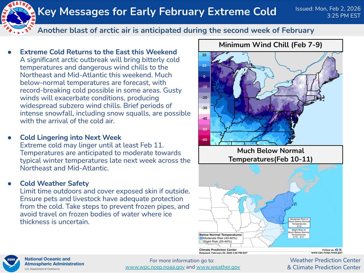
“A significant arctic outbreak will bring bitterly cold temperatures and dangerous wind chills to the Northeast and Mid-Atlantic this weekend,” the National Weather Service reports. “Much below-normal temperatures are forecast, with record-breaking cold possible in some areas. Gusty winds will exacerbate conditions, producing widespread subzero wind chills. Brief periods of intense snowfall, including snow squalls, are possible with the arrival of the cold air.”
In Connecticut, daytime temperatures on Saturday and Sunday are only expected to be in the teens, while nighttime lows starting on Friday will dip to the single digits or below zero, according to the National Weather Service.
Read More:
- Men Accused Of Doctor Impersonation Scheme, ‘Placing Patients At Significant Risk’: Feds
- Firehouse Subject To Carbon Monoxide Emergency: FD
- Man Who Posed As FBI Agent Enters Plea, Prosecutors Say
Here are the forecast details for southern Connecticut via the National Weather Service:
Today: Sunny, with a high near 33. Wind chill values between 10 and 20. West wind around 6 mph.
Tonight: Partly cloudy, with a low around 14. Calm wind.
Wednesday: Sunny, with a high near 32. Wind chill values between 15 and 25. Northwest wind 3 to 8 mph.
Wednesday Night: Partly cloudy, with a low around 11. Calm wind.
Thursday: Sunny, with a high near 30. North wind 3 to 6 mph.
Thursday Night: Partly cloudy, with a low around 8.
Friday: Partly sunny, with a high near 29.
Friday Night: A 30 percent chance of snow showers before midnight. Mostly cloudy, with a low around 8.
Saturday: Sunny and cold, with a high near 18.
Saturday Night: Mostly clear, with a low around 2.
Sunday: Mostly sunny and cold, with a high near 17.
Here are the forecast details for northern Connecticut via the National Weather Service:
Today: Mostly sunny, with a high near 32. Calm wind becoming south around 5 mph in the afternoon.
Tonight: Mostly cloudy, with a low around 7. Light and variable wind.
Wednesday: Sunny, with a high near 29. Light northwest wind increasing to 5 to 9 mph in the morning.
Wednesday Night: Mostly clear, with a low around 5. Light northwest wind.
Thursday: Mostly sunny, with a high near 28. Calm wind becoming northwest 5 to 7 mph in the afternoon.
Thursday Night: Partly cloudy, with a low around -1. Light northwest wind.
Friday: Partly sunny, with a high near 27. Calm wind becoming south 5 to 7 mph in the afternoon.
Friday Night: A chance of snow between 7 p.m. and 3 a.m. Mostly cloudy, with a low around 4. Light and variable wind becoming west 5 to 9 mph after midnight. Chance of precipitation is 40%.
Saturday: Mostly sunny, with a high near 13. Northwest wind 14 to 18 mph, with gusts as high as 32 mph.
Saturday Night: Mostly clear, with a low around -4. Northwest wind 10 to 14 mph, with gusts as high as 26 mph.
Sunday: Mostly sunny, with a high near 13. Northwest wind 10 to 14 mph.
Get more local news delivered straight to your inbox. Sign up for free Patch newsletters and alerts.