Weather
Old Farmer’s Almanac Summer 2020 Predictions For Connecticut
Some states will see a lot of rain. Others can expect scorching heat. Here's what the Almanac says for Connecticut.

ACROSS CONNECTICUT—With the spring season mostly gone, thoughts are now turning to the summer in Connecticut.
The Old Farmer’s Almanac, founded in 1792, is predicting our state can expect “sizzle and drizzle” weather in the coming summer months.
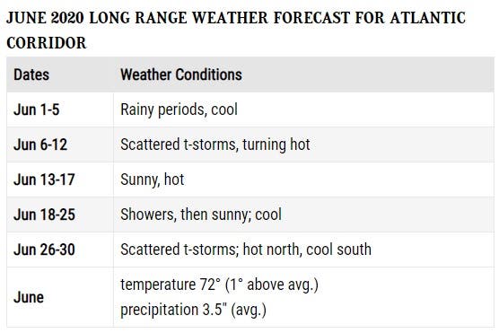
In June, the Almanac predicts our state will see “rainy periods followed by cool temps” for the first five days of the month. Our state will experience scattered thunderstorms before the weather turns hot June 6-12. To view the rest of the 2020 long-range forecast, see below:
Find out what's happening in Across Connecticutfor free with the latest updates from Patch.
Summer officially begins with the solstice on Saturday, June 20.
For most of the United States, summer’s hottest periods won’t occur until July. “Summer’s steamiest weather will hold off until mid-July in most areas,” said Almanac editor Michael Steinberg.
Find out what's happening in Across Connecticutfor free with the latest updates from Patch.
While the summer is expected to be a scorcher across the United States in 2020, the Old Farmer’s Almanac also predicts elevated amounts of rainfall from Texas to Canada, and eastward to the Atlantic Ocean.
The Almanac’s weather forecast methodology comes from a secret formula that was created by its founder, Robert Thomas, in 1792. The exact prediction process remains a secret, but the periodical discloses it uses solar science, climatology and meteorology to make its forecasts.
The Old Farmer’s Almanac, which is not to be confused with its rival forecast predictor, Farmers’ Almanac, is North America’s oldest continuously published periodical, according to its website.
Here is a look at Connecticut's short-term weather forecast via the National Weather Service:
Tuesday
Mostly cloudy, then gradually becoming sunny, with a high near 79. South wind 3 to 8 mph.
Tuesday Night
Patchy drizzle and fog after midnight. Increasing clouds, with a low around 59. South wind 5 to 7 mph becoming calm after midnight.
Wednesday
Mostly cloudy, then gradually becoming sunny, with a high near 79. South wind 3 to 8 mph.
Wednesday Night
Patchy fog after 1am. Otherwise, mostly cloudy, with a low around 63.
Thursday
Mostly cloudy, with a high near 78.
Thursday Night
A chance of showers, with thunderstorms also possible after 8pm. Mostly cloudy, with a low around 64. Chance of precipitation is 50%.
Friday
A 50 percent chance of showers and thunderstorms. Patchy fog before 8am. Otherwise, cloudy, with a high near 78.
Friday Night
A 40 percent chance of showers and thunderstorms. Patchy fog after 10pm. Otherwise, mostly cloudy, with a low around 59.
Saturday
Partly sunny, with a high near 76.
Saturday Night
Partly cloudy, with a low around 52.
Sunday
Sunny, with a high near 74.
Get more local news delivered straight to your inbox. Sign up for free Patch newsletters and alerts.