Weather
Powerful Nor'easter: Here's What Impact It Will Have On CT
A strong storm will be moving near Connecticut tomorrow and here are the latest updates on what we can expect.


CONNECTICUT — A powerful low pressure system, also called a nor'easter, is expected to be in the vicinity of Connecticut late Tuesday and early Wednesday, but as of right now it's expected that the state will only see a glancing blow from this storm.
Parts of Connecticut, especially in far northern areas may see some snow, possibly even heavy at times early on Wednesday. Most of Connecticut is looking at some rain Tuesday night and Wednesday morning and increasing wind gusts as the storm is expected to remain off of the coast.
The storm's current track has the low pressure system largely staying far enough away from Connecticut to ensure we don't receive a direct hit.
Find out what's happening in Across Connecticutfor free with the latest updates from Patch.
To give you an idea of how powerful this storm is, Accuweather.com says this. "Gusts near the center of the offshore storm may approach hurricane force (74 mph or greater), while seas of 15-25 feet are likely with locally higher winds and waves."
But here is what Accuweather.com thinks Connecticut will actually see. "The swath from Washington, D.C., to Philadelphia, New York City and Hartford, Connecticut, may get a bit of rain and a breeze from the storm on its most northwestward extent."
Find out what's happening in Across Connecticutfor free with the latest updates from Patch.
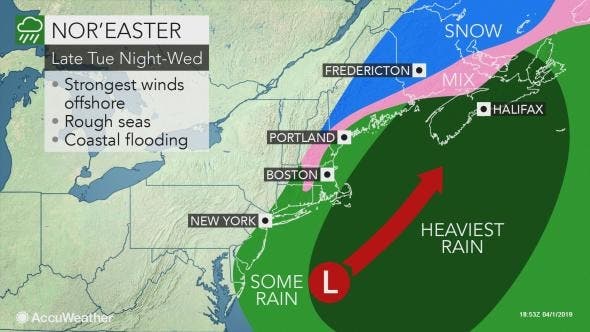
image via Accuweather.com
Connecticut is looking at another cold night with temps in the 20s and 30s statewide tonight. Tuesday will remain chilly with temps in the upper 40s and clouds will roll in during the day as "an area of low pressure approaches from the south."
"While the daylight hours are expected to remain dry, rain will overspread the region after sunset and continue through the night before dry weather returns on Wednesday ... After remaining several degrees below normal on Tuesday, high temperatures on Wednesday will rebound to around 60 across much of the area, a few degrees above normal for early April."
And if you have outdoor plans for next weekend, hopefully it's on Sunday.
The amount of people who trolled me on Facebook for posting about this storm last week was almost record breaking. Sort of hope it snows now. Here's a look at 1"+ and 3"+ snow probabilities off the Euro. Will have to watch for a brief flip to heavy wet snow Wednesday AM. #nbcct pic.twitter.com/ZdorAq2xOH
— Ryan Hanrahan (@ryanhanrahan) April 1, 2019
Rain Wednesday morning may turn to a period of wet snow - especially in the Northeast Hills. By afternoon temperatures will climb to near 60! #nbcct pic.twitter.com/PuUfT6tw5X
— Ryan Hanrahan (@ryanhanrahan) April 1, 2019
Rain tomorrow night into Wednesday morning could end as a bit of wet snow in parts of the hills. No #aprilfools Then in true New England fashion, we're sunny, near 60 by afternoon. pic.twitter.com/d7rmmRox0J
— Rachel Frank (@RachelFrank_CT) April 1, 2019
Here is the updated weather forecast for Southern Connecticut:
Tonight
Clear, with a low around 28. Northwest wind 5 to 10 mph becoming light and variable in the evening.
Tuesday
Sunny, with a high near 48. Wind chill values between 25 and 35 early. Southeast wind 6 to 13 mph.
Tuesday Night
Rain likely, mainly between 11pm and 5am. Mostly cloudy, with a low around 39. East wind around 11 mph becoming north after midnight. Winds could gust as high as 21 mph. Chance of precipitation is 60%. New precipitation amounts between a tenth and quarter of an inch possible.
Wednesday
A 30 percent chance of rain before 8am. Mostly cloudy, then gradually becoming sunny, with a high near 59. Wind chill values between 30 and 40 early. North wind 13 to 18 mph becoming west in the afternoon. Winds could gust as high as 28 mph.
Wednesday Night
Mostly clear, with a low around 39. West wind 6 to 11 mph.
Thursday
Mostly sunny, with a high near 51.
Thursday Night
Mostly cloudy, with a low around 36.
Friday
A 50 percent chance of rain after 10am. Mostly cloudy, with a high near 48.
Friday Night
Rain likely, mainly before 3am. Cloudy, with a low around 42. Chance of precipitation is 60%.
Saturday
A 30 percent chance of rain before 4pm. Mostly cloudy, with a high near 58.
Saturday Night
Mostly cloudy, with a low around 45.
Sunday
Partly sunny, with a high near 57.
Sunday Night
Mostly cloudy, with a low around 45.
Here is the updated weather forecast for Northern Connecticut:
Tonight
Clear, with a low around 22. Northwest wind 11 to 16 mph becoming light after midnight.
Tuesday
Sunny, with a high near 50. South wind 5 to 10 mph.
Tuesday Night
A chance of rain, mainly after 2am. Mostly cloudy, with a low around 35. Southeast wind 5 to 8 mph becoming calm after midnight. Chance of precipitation is 30%. New precipitation amounts of less than a tenth of an inch possible.
Wednesday
A slight chance of rain before 9am. Cloudy through mid morning, then gradual clearing, with a high near 59. North wind around 7 mph. Chance of precipitation is 20%.
Wednesday Night
Mostly clear, with a low around 37. Northwest wind 5 to 9 mph.
Thursday
Mostly sunny, with a high near 53. West wind around 7 mph.
Thursday Night
Mostly cloudy, with a low around 35. Northwest wind around 6 mph becoming calm after midnight.
Friday
A chance of rain after noon. Cloudy, with a high near 50. Southeast wind around 6 mph. Chance of precipitation is 40%.
Friday Night
Rain likely, mainly after 10pm. Cloudy, with a low around 41. Southeast wind 3 to 7 mph. Chance of precipitation is 70%.
Saturday
A chance of rain. Mostly cloudy, with a high near 59. Light and variable wind becoming west around 5 mph in the afternoon. Chance of precipitation is 40%.
Saturday Night
Partly cloudy, with a low around 43. North wind around 5 mph becoming calm in the evening.
Sunday
Mostly sunny, with a high near 62. Light and variable wind.
Sunday Night
Partly cloudy, with a low around 43. South wind around 5 mph becoming calm in the evening.
Get more local news delivered straight to your inbox. Sign up for free Patch newsletters and alerts.


