Weather
CT Weather: Thunderstorms, Heavy Rain Dominate Forecast
And here is the latest Monday update on Hurricane Florence's expected path and what impacts the storm may have on CT.


The first few days of this week will largely be unpleasant with heavy rain and a chance for thunderstorms later tonight and Tuesday. For us in Connecticut, Hurricane Florence is expected to stay south of us though the storm is powerful enough that it may cause weather impacts for us later in the week.
Hurricane Florence is expected to make landfall somewhere in the Carolinas on Thursday. The size and strength of Hurricane Florence is very concerning. Hurricane Florence is currently a category two hurricane this morning and is expected to intensify into a category four storm before making landfall Thursday morning.
As for us in Connecticut, the National Weather Service says, "A wet, cool and windy day is expected as high pressure moves into the Canadian Maritimes and a warm front approaches from the south. A steady rain is forecast along with cooler than normal temperatures. Gusty easterly winds will prevail today.
Find out what's happening in Across Connecticutfor free with the latest updates from Patch.
Showers and possible thunderstorms are forecast tonight into Tuesday as the warm front lifts through. Winds will diminish as they turn toward the south, and warmer, more humid air will be ushered in. Temperatures remain steady in the 60s tonight, then warm into the 80s Tuesday."
WTNH News 8 Meteorologist Gil Simmons said, "Rainy and windy for the day today! A chilly feel with high temperatures mostly in the 50s. I am expecting some thunderstorms this evening and overnight tonight as humidity arrives for tomorrow. Warm and humid with scattered showers and thunderstorms Tuesday and Wednesday. Drying out at the end of the week. We are also watching #HurricaneFlorence with a big impact expected in the Carolinas!"
Find out what's happening in Across Connecticutfor free with the latest updates from Patch.
We will have to watch the threat for some strong/severe thunderstorms tomorrow night. #nbcct pic.twitter.com/hwlCib6G8X
— Ryan Hanrahan (@ryanhanrahan) September 10, 2018
Ewww! Pretty nasty weather on tap for today as temperatures stay cool, skies stay cloudy, and rain falls on & off all day. Showers and possible thunderstorms linger into tonight. Bleh. And to think that it was in the 90s much of last week... pic.twitter.com/R94d02apae
— Dan Amarante (@DanAmarante) September 10, 2018
Hurricane Florence is strengthening, and is back up to a Category 2 in the 5 AM update. It's still projected to head towards the US East Coast, with the Carolinas the most likely landfall at this point. pic.twitter.com/SZdyKErEji
— Dan Amarante (@DanAmarante) September 10, 2018
Still plenty of spread with #Florence. South Carolina still needs to be prepared for a direct landfall. #nbcct pic.twitter.com/mLdMy2PB1g
— Ryan Hanrahan (@ryanhanrahan) September 10, 2018
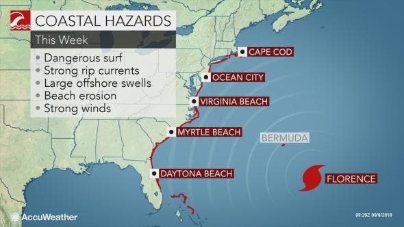
Image via Accuweather.com
See related: Florence Becomes 'Extremely Dangerous' Category 3 Hurricane
Here is the updated weather forecast for Southern Connecticut:
Today
Rain. High near 66. Breezy, with an east wind around 21 mph, with gusts as high as 34 mph. Chance of precipitation is 100%. New precipitation amounts between a quarter and half of an inch possible.
Tonight
Showers and possibly a thunderstorm. Some of the storms could produce heavy rain. Patchy fog after midnight. Temperature rising to around 68 by 2am. Breezy, with a southeast wind 10 to 20 mph, with gusts as high as 30 mph. Chance of precipitation is 90%. New rainfall amounts between a half and three quarters of an inch possible.
Tuesday
A 50 percent chance of showers and thunderstorms. Some of the storms could produce heavy rain. Patchy fog before 9am. Otherwise, mostly cloudy, with a high near 81. South wind around 9 mph.
Tuesday Night
A 40 percent chance of showers and thunderstorms. Cloudy, with a low around 71. South wind around 5 mph becoming calm in the evening.
Wednesday
A 40 percent chance of showers and thunderstorms. Mostly cloudy, with a high near 82. Northeast wind 3 to 7 mph.
Wednesday Night
A 30 percent chance of showers and thunderstorms. Cloudy, with a low around 71.
Thursday
Mostly cloudy, with a high near 78.
Thursday Night
Mostly cloudy, with a low around 68.
Friday
Partly sunny, with a high near 80.
Friday Night
Mostly cloudy, with a low around 66.
Saturday
Partly sunny, with a high near 79.
Saturday Night
Partly cloudy, with a low around 66.
Sunday
Mostly sunny, with a high near 78.
Here is the updated weather forecast for Northern Connecticut:
Today
Rain. Patchy fog after 11am. High near 64. East wind around 10 mph. Chance of precipitation is 100%. New precipitation amounts between a half and three quarters of an inch possible.
Tonight
Showers and thunderstorms. Some of the storms could produce heavy rain. Patchy fog. Temperature rising to around 68 by 5am. East wind 5 to 10 mph. Chance of precipitation is 80%. New rainfall amounts between a half and three quarters of an inch possible.
Tuesday
Showers and thunderstorms likely, mainly before 10am. Some of the storms could produce heavy rain. Patchy fog before 2pm, then patchy fog after 5pm. Otherwise, mostly cloudy, with a high near 80. South wind around 6 mph. Chance of precipitation is 60%. New rainfall amounts between a quarter and half of an inch possible.
Tuesday Night
A chance of showers and thunderstorms, mainly before 4am. Some of the storms could produce heavy rain. Patchy fog before 7pm, then patchy fog after 8pm. Otherwise, mostly cloudy, with a low around 68. Light south wind. Chance of precipitation is 30%. New rainfall amounts of less than a tenth of an inch, except higher amounts possible in thunderstorms.
Wednesday
A chance of showers and thunderstorms, mainly after 7am. Some of the storms could produce heavy rain. Patchy fog before 9am. Otherwise, mostly cloudy, with a high near 81. Light north wind. Chance of precipitation is 40%.
Wednesday Night
A chance of showers and thunderstorms. Some of the storms could produce heavy rain. Patchy fog. Otherwise, mostly cloudy, with a low around 68. Chance of precipitation is 40%.
Thursday
A chance of showers before 1pm. Patchy fog before 9am. Otherwise, mostly cloudy, with a high near 80. Chance of precipitation is 40%.
Thursday Night
Patchy fog. Otherwise, mostly cloudy, with a low around 66.
Friday
Areas of fog before 8am. Otherwise, partly sunny, with a high near 81.
Friday Night
Partly cloudy, with a low around 63.
Saturday
Mostly sunny, with a high near 80.
Saturday Night
Partly cloudy, with a low around 62.
Sunday
Partly sunny, with a high near 80.
Get more local news delivered straight to your inbox. Sign up for free Patch newsletters and alerts.


