Weather
Is Winter Over In Connecticut? Several Forecasters Weigh In
Dairy Queen may be open, but is spring really here? See what several forecasters have to say about that.

Dairy Queen may be open, but is spring really here?
After a series of slushy winter storms in late February and early March that delayed and closed schools and caused travel problems, could the weather finally be turning for good?
Officially, spring isn't until March 20. But as we know, Mother Nature does not adhere to a calendar. Remember last year? So here's what multiple forecasters have to say about whether or not you can put away that snow shovel for the season:
Find out what's happening in Across Connecticutfor free with the latest updates from Patch.
NATIONAL WEATHER SERVICE
Find out what's happening in Across Connecticutfor free with the latest updates from Patch.
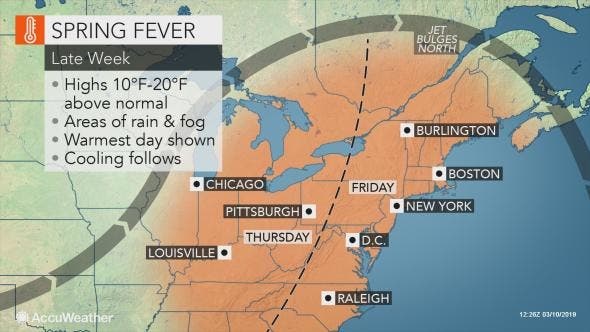
The National Weather Service's long-range forecast looks to be relatively calm until later this week. Wednesday will be sunny with temps in the upper 40s and Thursday looks perfect with sunshine and temps in the mid to upper 50s.
There is a chance of rain Thursday night into Friday, and thunderstorms are even possible during the day Friday. Saturday looks like a picture perfect late winter day as temps will be in the low 50s with plenty of sunshine. Sunday also looks sunny but colder with temps in the low 40s.
The National Weather Service says, "Showers will develop ahead of the cold front Thursday night, with the bulk of the precipitation still expected to occur on Friday. There is also the potential for some thunderstorms to develop. Temperatures will be above normal and dewpoints will be on the rise Thursday into Friday, with advection fog likely developing near the coast."
"Dry and cool conditions expected for the weekend as high pressure builds behind the frontal passage. Temperatures on Saturday will remain mild with highs in the upper 40s to lower 50s then drop to slightly below normal on Sunday with highs in the low to mid 40s. A weak northern stream system may then affect the area on Monday bringing a few rain/snow showers to the region. High pressure moves back in for Tuesday with temperatures remaining slightly below normal."
The National Weather Service says in its long-range forecast that from March 20-26 temps will be above average as we begin spring and precipitation will be below normal during this time period.
Above normal temps are expected from March 26 into April 5 but the precipitation is also expected to be above average during this time period. (Keep up with CT events and news by subscribing to Patch to receive daily newsletters and breaking news alerts.)
ACCUWEATHER
Wednesday and Thursday will likely be the nicest days in recent weeks with some sunshine and highs in the 50s for Connecticut, Accuweather says.
"A strong southerly flow of air from the Gulf of Mexico will pump in even milder air across the Northeast later this week, making it feel more like spring," AccuWeather Meteorologist Brett Rathbun said. Highs may be as much as 20 degrees above mid-March normals on the warmest days.
Accuweather
Don't get too excited, through: While the mild conditions give us some hope, forecasters with Accuweather say it's not yet time to declare an end to winter. Some chilly temperatures will make their way back to the region by late weekend and early next week.
WEATHER CHANNEL
Connecticut could see 60 degrees on Friday but this also includes rain in the forecast, the Weather Channel says. Once the rain ends, drier conditions will follow.
"Beginning this weekend, the central and eastern U.S. will see dry conditions develop. Most locations will stay dry into midweek. However, a couple of disturbances will track through portions of the Plains, Midwest, South and East mid- to late-week, but no big cross-country storms are currently expected next week," according to the Weather Channel.
The Weather Channel is predicting that Connecticut may still see some snow chances between now and the end of March. As of now, the Weather Channel is predicting morning snow showers on Thursday, March 21, Friday, March 22 and Saturday, March 23.
For those looking ahead to spring, the Weather Channel is predicting a normal amount of precipitation but temps to be warmer than average from now through May.
Connecticut's Weather Experts Weigh In
Maybe a window for something interesting middle of next week but I'm not that excited about it now. #nbcct pic.twitter.com/jGThVnKiUW
— Ryan Hanrahan (@ryanhanrahan) March 12, 2019
We're missing a nasty one this week. The indirect effect of this major storm will be to make our temps milder! pic.twitter.com/9GKlxPzMkM
— Rachel Frank (@RachelFrank_CT) March 12, 2019
One storm, multiple threats for the central US: Blizzard conditions, severe thunderstorms, high winds and a flood threat! All we get locally is a few showers and a mild day Friday... pic.twitter.com/kQbW5sGca1
— Rachel Frank (@RachelFrank_CT) March 12, 2019
Colder again next week. All this “spring fever” fun doesn’t mean we’re done with snow yet. It’s New England.
— Rachel Frank (@RachelFrank_CT) March 12, 2019
Get more local news delivered straight to your inbox. Sign up for free Patch newsletters and alerts.


