Home & Garden
Heavy Rain, Possible Thunderstorms in Brookfield's Work Week Forecast
Temperatures will run very warm for the first half of the week and then we'll see a coo ldown in time for Super Bowl weekend.

Written by BRIAN MCCREADY (Patch Staff)
Another normal week of winter weather, temperatures forecast into the mid to upper 50s, heavy rains, and a chance of thunderstorms, too.
*Tongue firmly in cheek*
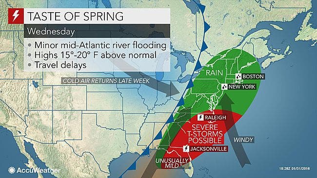
Despite the calendar turning to Feb. 1, the forecast at least through Wednesday will almost be spring-like, a continuation of our warm winter thus far throughout Fairfield County.
As of right now, no snow is in the forecast through this upcoming weekend, though a significant rainstorm is forecast for all day Wednesday.
Here is what we can expect for the next seven days via the National Weather Service:
Monday: slight chance of showers, mostly cloudy skies and temperatures in the mid 50s.
Tuesday: sunny skies and temps in the upper 40s, though early on it will feel between 25-35 degrees because of the windchill factor.
Wednesday: Rain moves in before dawn and lasts until around 9 p.m. The entire state is looking at between 1-2 inches of rain and some isolated thunderstorms are even possible. Temps will be in the mid 50s.
Thursday: more sun and temps in the mid 40s.
Friday: a cooldown of sorts begins as temps will be in the upper 30s and sunny skies.
Saturday: sunny skies and temps near 40 degrees.
Super Bowl Sunday: sunny skies and temps in the low 40s.
Patch Editor Alfred Branch contributed to this report.
Photo credit: AccuWeather.com
Get more local news delivered straight to your inbox. Sign up for free Patch newsletters and alerts.