Home & Garden
Latest on Connecticut's First Winter Storm of the Season
In just 24 hours there has been changes to the forecast, and we'll let you know when and how much snow, sleet and rain to expect.


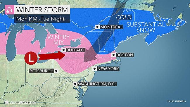
A lot has changed in 24 hours concerning the anticipated season’s first winter storm predicted for late Monday into Tuesday.
In reality this will barely register as a winter storm for a lot of us, according to the latest National Weather Service forecast, especially on the immediate Connecticut coastline from Greenwich to New London.
We’re still all expected to receive some snowflakes and mixed precipitation but the major change from yesterday’s forecast is that the time period of actual snow and sleet will be much less than originally anticipated.
The changeover from snow to sleet to plain rain is expected to happen much quicker statewide now, which will keep accumulation totals low except in Hartford and Tolland counties, which may receive actual shovelable snow.
Here is the latest detailed forecast for timing and possible accumulation:
Immediate Connecticut coastline including southern Fairfield, southern New Haven, southern Middlesex and southern New London counties: During the day on Monday it will be sunny and temps will drop 35 degrees by 4 p.m. and the windchill will make it feel like it is 25 degrees.
Late Monday, there is a chance of snow and sleet till 1 a.m. and then from 1 a.m. to 4 a.m. there will be a period of sleet and rain, and by 4 a.m. it’s all plain rain. Less than a half inch of slushy snow and sleet accumulation is predicted now.
Northern Fairfield, northern New Haven, northern Middlesex, and northern New London counties: Snow and sleet late Monday and it continues until 4 a.m. Tuesday. After 4 a.m. freezing rain mixes in, which continues until 10 a.m. and then it’s plain rain. One inch of snow and sleet is expected, which could definitely impact Tuesday’s commute to work.
Hartford and Tolland counties: Snow begins late Monday night and continues in the overnight hours before mixing late Tuesday morning with some sleet and freezing rain. You could see between 2-4 inches of snow before the precipitation changes to rain in the afternoon.
Latest New Year’s Eve forecast: Cloudy with some rain before 3 p.m. and temps near 50 degrees. But the good news here is it appears to be cloudy with no rain as the ball drops and temps will only dip to 35 or so.
Photo credit: Accuweather.com
Get more local news delivered straight to your inbox. Sign up for free Patch newsletters and alerts.