Community Corner
'Crippling and Potentially Historic Blizzard' Takes Aim at Cheshire
The National Weather Service is advising residents not to travel from Monday evening into Tuesday.

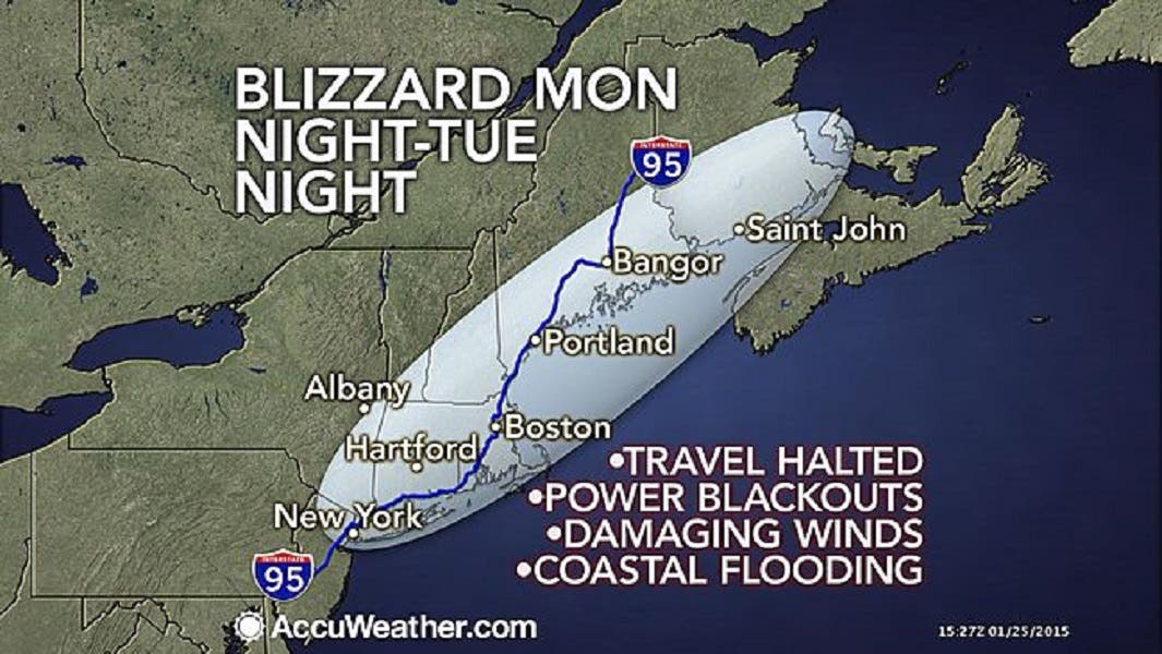
Calling it a “crippling and potentially historic blizzard,” the National Weather Service is advising against traveling from Monday evening through Tuesday because of a blizzard that could dump up to 30 inches of snow on Cheshire.
The National Weather Service just scrapped its Blizzard Watch and replaced it with a Blizzard Warning that begins at 1 p.m. Monday and runs until midnight.
The National Weather Service predicts Cheshire will receive 20-30 inches of snow with snowfall rates of 2-4 inches of snow per hour.
Find out what's happening in Cheshirefor free with the latest updates from Patch.
Winds of 30-40 mph are expected with gusts up to 65 miles per hour.
To sign up for Cheshire breaking news alerts and more, click here.
Find out what's happening in Cheshirefor free with the latest updates from Patch.
The details
Light snow begins in the morning accumulating 1-3 inches of snow by Monday evening’s commute.
Snow intensifies Monday night and the heaviest snow is forecast from midnight Tuesday until Tuesday afternoon.
The National Weather Service is not playing around when it comes to the severity of this storm saying it could lead to “life-threatening conditions” and that traveling will be “extremely dangerous.”
White-out conditions are expected and if you do travel the National Weather Service urges you to bring a survival kit.
Below is Cheshire’s detailed forecast for the blizzard, according to the National Weather Service:
- Monday: A slight chance of snow before 9am, then widespread blowing snow and a chance of snow between 9am and 3pm, then snow likely with widespread blowing snow after 3pm. Cloudy, with a high near 24. Wind chill values between 5 and 15. Northeast wind 8 to 11 mph, with gusts as high as 24 mph. Chance of precipitation is 70%. New snow accumulation of 1 to 2 inches possible.
- Monday Night: Snow with widespread blowing snow. The snow could be heavy at times. Some thunder is also possible. Low around 18. Wind chill values between zero and 10. Windy, with a north wind 18 to 23 mph increasing to 25 to 30 mph after midnight. Winds could gust as high as 47 mph. Chance of precipitation is 100%. New snow accumulation of 11 to 17 inches possible.
- Tuesday: Snow with widespread blowing snow. The snow could be heavy at times. Some thunder is also possible. High near 23. Wind chill values between -5 and 5. Windy, with a north wind 29 to 36 mph, with gusts as high as 50 mph. Chance of precipitation is 100%. New snow accumulation of 10 to 14 inches possible.
- Tuesday Night: Snow with widespread blowing snow before 9pm, then snow likely with widespread blowing snow between 9pm and midnight, then widespread blowing snow and a chance of snow after midnight. Low around 11. Blustery, with a north wind 20 to 25 mph decreasing to 13 to 18 mph after midnight. Winds could gust as high as 40 mph. Chance of precipitation is 90%. New snow accumulation of 1 to 3 inches possible.
Get more local news delivered straight to your inbox. Sign up for free Patch newsletters and alerts.