Community Corner
WEATHER ALERT: Clinton Under Blizzard Watch
The heaviest blizzard conditions will occur Monday night into Tuesday.

A blizzard watch is in effect for the area. The National Weather Service posted the following details:
- Hazard types: Heavy snow and blowing snow
- Winds: North 25 to 35 mph, with gusts up to 50 mph
- Visibilities: One quarter mile or less at times.
- Timing: Heaviest snow and strongest winds will occur overnight Monday into Tuesday
- Impacts: Extremely dangerous travel due to heavy snowfall and strong winds with white-out conditions likely
- Secondary and tertiary roads may become impassable
- Strong winds may down power lines and tree limbs
Meteorologist Ryan Hanrahan said: “Worst of the blizzard (wind/snow) will come Tuesday morning around daybreak. It will be a long duration event.”
Meteorologist Gil Simmons urged Connecticut residents to prepare for the storm today.
Find out what's happening in Clintonfor free with the latest updates from Patch.
Detailed NWS Forecast
- Sunday: Mostly sunny, with a high near 38. Wind chill values between 25 and 30. Northwest wind 10 to 14 mph.
- Sunday Night: Tonight A slight chance of snow after midnight. Increasing clouds, with a low around 14. Wind chill values between 5 and 10. North wind around 7 mph. Chance of precipitation is 20%.
- Monday: A chance of snow before noon, then snow likely with areas of blowing snow after noon. Cloudy, with a high near 27. Wind chill values between 5 and 15. Northeast wind 7 to 17 mph, with gusts as high as 30 mph. Chance of precipitation is 70%. New snow accumulation of less than one inch possible.
- Monday Night: Snow with areas of blowing snow. The snow could be heavy at times. Low around 26. Wind chill values between 10 and 15. Windy, with a north wind 21 to 30 mph, with gusts as high as 43 mph. Chance of precipitation is 90%. New snow accumulation of 7 to 11 inches possible.
- Tuesday: Snow with areas of blowing snow. The snow could be heavy at times. High near 27. Windy, with a north wind 24 to 30 mph, with gusts as high as 44 mph. Chance of precipitation is 90%. New snow accumulation of 4 to 8 inches possible.
- Tuesday Night: Snow likely, mainly before midnight. Cloudy, with a low around 16. Blustery. Chance of precipitation is 60%. New snow accumulation of 1 to 2 inches possible.
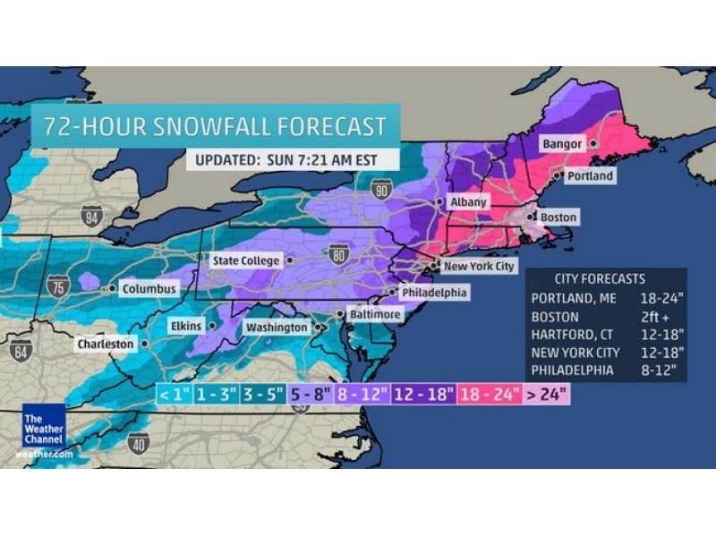
Photo: The Weather Channel
Find out what's happening in Clintonfor free with the latest updates from Patch.
Get more local news delivered straight to your inbox. Sign up for free Patch newsletters and alerts.