Weather
Hazardous Weather Outlook Issued For Connecticut as Hurricane Matthew Makes Landfall in Haiti
Local meteorologists say Connecticut is likely to receive some impact from Matthew as the state is now in the "cone of uncertainty."

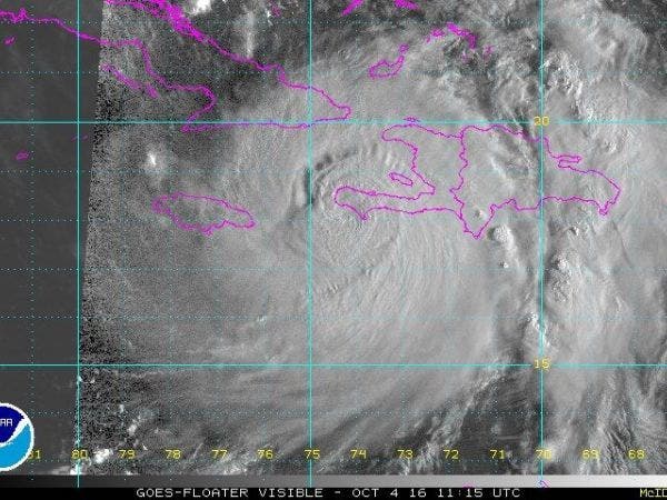
Hurricane Matthew appears more likely to make a landfall in the U.S. by this weekend, as the dangerous storm slammed into Les Anglais, Haiti, early Tuesday morning. According to the National Hurricane Center, Matthew remained a strong Category 4 storm with 145 mph maximum sustained winds.
Gusty winds and heavy rain are an increasing possibility for Connecticut, as a new track for the storm reveals that Connecticut is now in the "cone of uncertainty" for this coming weekend, according to local meteorologists.
Already, the National Weather Service has issued a Hazardous Weather Outlook for Connecticut for this weekend in relation to the impacts Matthew might have on the region.
Find out what's happening in Darienfor free with the latest updates from Patch.
The weather service states that Matthew is expected to be just off the southeast coast on Saturday, but there is still “much uncertainty with the track of this system as we head into the weekend and too early to mention specific impacts.”
NBC Connecticut meteorologist Ryan Hanrahan said on social media Tuesday at 11 a.m. that the "latest track of Matthew from the National Hurricane Center brings the hurricane onshore in the Carolinas and close to southern New England. We're now in the 5-day cone.'"
Find out what's happening in Darienfor free with the latest updates from Patch.
Earlier on Tuesday morning, Hanrahan added that “getting *some* impact from Hurricane Matthew could be a good thing for Connecticut" as we could receive a couple inches of rain.
"Great for the drought and most of the state keeps the lights on," Hanrahan said Tuesday morning on social media.
Breaking: Connecticut is in the cone or uncertainty of #Matthew. Some impact more likely here. #FirstAlertCT pic.twitter.com/PRnoJsAekX
— Ryan Hanrahan (@ryanhanrahan) October 4, 2016
WTNH News 8 meteorologist Gil Simmons said Tuesday morning that the new Hurricane Matthew track calls for possible landfall in North and South Carolina and a hurricane south of Long Island Sunday morning.
Matthew despite going over land in Haiti still CAT 4 More computer models bring it(weakened) to CT then out to sea pic.twitter.com/YXHINabN3w
— Joe Furey (@StormFurey) October 4, 2016
The hurricane center anticipates tropical storm or hurricane watches will likely be issued for most of Florida's Atlantic coast at some point on Tuesday. Florida and North Carolina have issued a state of emergency.
The current forecast may mean significant impacts to Georgia, South Carolina and the Mid-Atlantic states, as well. Hurricane Matthew was located about 10 miles east of Tiburon, Haiti, as of the hurricane center’s 8 a.m. Tuesday update. The storm was moving north at 9 mph.
The system is expected to move near eastern Cuba after clearing Haiti. Forecasters say the storm is expected to turn northwest Wednesday night, putting it on a trek to run the coastline of Florida, Georgia and the Carolinas.
Options for Hurricane Matthew's path include a landfall in the Carolinas, a northward turn along the Atlantic Seaboard or a curve out to sea late this weekend, according to AccuWeather.com
There's at least a chance of tropical storm-force winds and heavy rain for the Mid-Atlantic and New England coast, with significant wind and rain threats even if the storm stays far offshore, according to The Weather Channel.
Once past North Carolina, Matthew will accelerate and lift northeast. But how far off the coast it tracks will dictate any impacts here. pic.twitter.com/5H2xP8BQKe
— Dan Skeldon (@ACPressSkeldon) October 4, 2016
On Tuesday morning, hurricane-force winds were extending out from Matthew up to 40 miles. Tropical storm-force winds extended out 185 miles.
Hurricane Matthew’s formation came during the peak of the 2016 Atlantic Hurricane Season. Forecasters at the hurricane center say the eight-week period that begins in mid-August and runs through mid-October is a “season within the season.” This eight-week period “is often the most active and dangerous time for tropical cyclone activity,” NOAA explained on its website.
The eight-week period is historically responsible for major spikes in tropical weather activity, NOAA said. In fact, it accounts for about 78 percent of all tropical storm days on record. It is also the period when 87 percent of the category 1 and 2 hurricane days on record occurred. In addition, this period is responsible for “a whopping 96 percent of the major (category 3, 4 and 5) hurricane days.”
With reporting by Sherri Lonon and Greg Hambrick | Graphics courtesy of NOAA
Get more local news delivered straight to your inbox. Sign up for free Patch newsletters and alerts.


