Weather
Here's How Remnants Of Former Hurricane Nate Will Impact Connecticut's Weather
Connecticut will be impacted by the remnants of Nate on Columbus Day and here's what to expect.

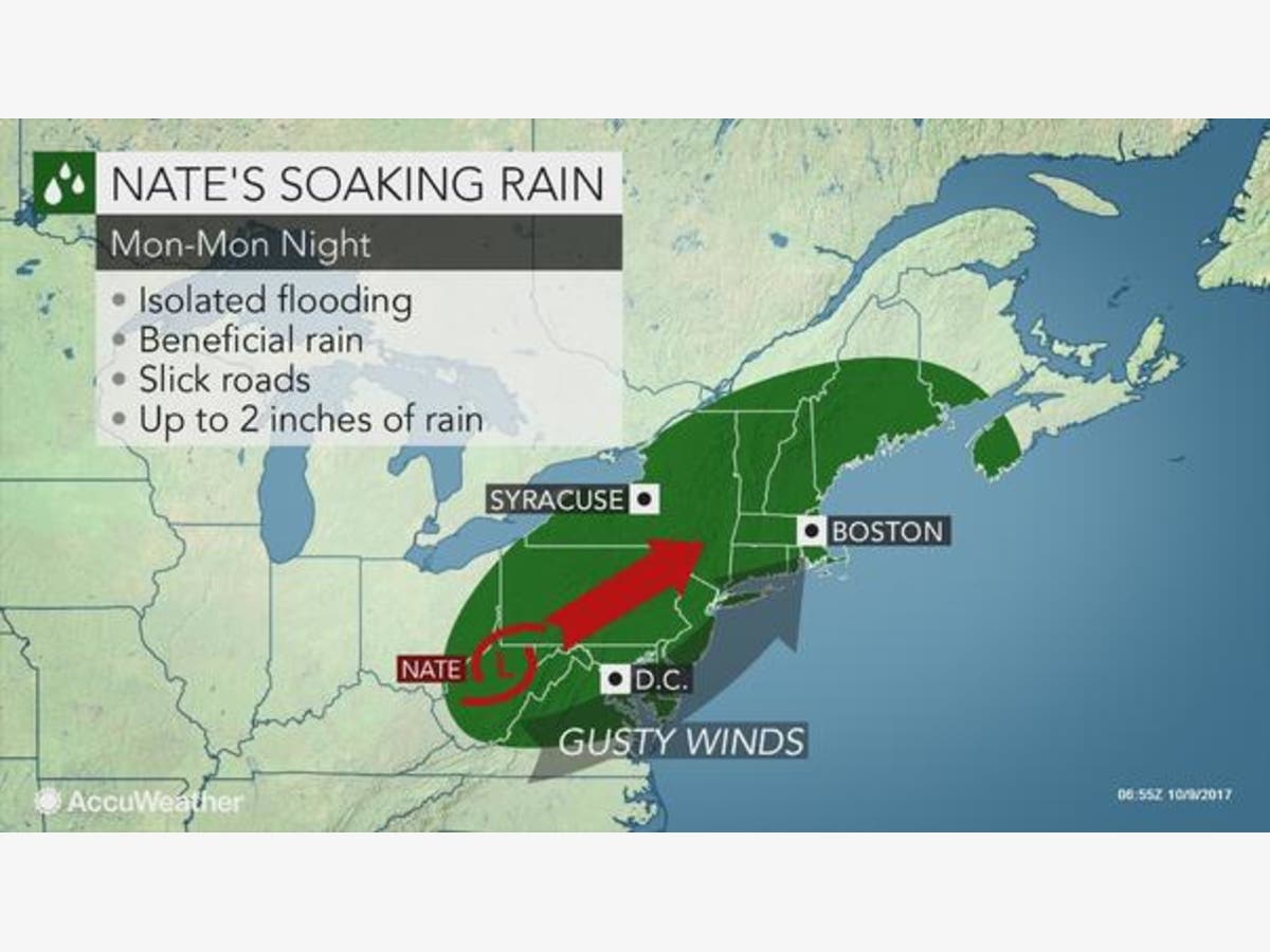
This isn’t the best forecast for Connecticut as we’ll see plenty of clouds this week and the remnants of former Hurricane Nate will bring heavy rain and wind to the state on Monday. The silver lining to the forecast is the weather actually looks to improve next weekend with plenty of sunshine and temps rebounding into the 70s.
Connecticut could see another inch of rain on Monday and there is a chance for more rain on Wednesday too. It will feel more like fall in the middle of the week with temps only in the low 60s. NBC Connecticut's Bob Maxon said, “Heavy rain and strong winds will be moving through the state today as we see the remnants of Nate.”
WTNH News 8 Meteorologist Gil Simmons said ,”Here's your Monday #instacast full of showers & wind today followed by sun, low humidity & warmth tomorrow! Have a great day & let's grab a hold of this week!”
Find out what's happening in Darienfor free with the latest updates from Patch.
I can see the rain for our area this afternoon already on radar in PA...take a look! The wind will also pick up! @WTNH #WTNHweather pic.twitter.com/kiFXsSug9N
— Gil Simmons (@gilsimmons) October 9, 2017
Here’s the updated seven-day weather forecast for Southern Connecticut via the National Weather Service:
Find out what's happening in Darienfor free with the latest updates from Patch.
Columbus Day: A chance of showers and thunderstorms, then occasional showers and possibly a thunderstorm after 11am. Some of the storms could produce heavy rain. High near 75. South wind 7 to 17 mph, with gusts as high as 29 mph. Chance of precipitation is 80%. New rainfall amounts between a tenth and quarter of an inch, except higher amounts possible in thunderstorms.
Tonight: Showers and thunderstorms likely before 11pm, then a slight chance of showers between 11pm and 1am. Some of the storms could produce heavy rain. Cloudy, then gradually becoming partly cloudy, with a low around 63. Southwest wind 7 to 15 mph becoming west after midnight. Chance of precipitation is 60%. New precipitation amounts of less than a tenth of an inch, except higher amounts possible in thunderstorms.
Tuesday: Mostly sunny, with a high near 79. Northwest wind around 8 mph.
Tuesday Night: Mostly clear, with a low around 61. North wind around 7 mph.
Wednesday: A 20 percent chance of light rain after noon. Increasing clouds, with a high near 70. East wind 10 to 13 mph.
Wednesday Night: A 40 percent chance of light rain. Cloudy, with a low around 53.
Thursday: Cloudy, with a high near 63.
Thursday Night: Cloudy, with a low around 54.
Friday: Cloudy, with a high near 68.
Friday Night: Mostly cloudy, with a low around 58.
Saturday: Mostly sunny, with a high near 73.
Saturday Night: Partly cloudy, with a low around 58.
Sunday: Mostly sunny, with a high near 76.
Here’s the updated 7-day forecast for Northern Connecticut via the National Weather Service:
Columbus Day: Showers likely and possibly a thunderstorm before 2pm, then showers between 2pm and 4pm, then showers and possibly a thunderstorm after 4pm. Patchy fog before 2pm, then patchy fog after 3pm. High near 75. Light south wind increasing to 8 to 13 mph in the morning. Winds could gust as high as 29 mph. Chance of precipitation is 100%. New rainfall amounts between a quarter and half of an inch possible.
Tonight: Showers and thunderstorms before 9pm, then a slight chance of showers between 9pm and 11pm. Patchy fog before 1am. Low around 63. Southwest wind 6 to 11 mph becoming northwest after midnight. Winds could gust as high as 24 mph. Chance of precipitation is 80%. New precipitation amounts between a tenth and quarter of an inch, except higher amounts possible in thunderstorms.
Tuesday: Patchy fog between 7am and 8am. Otherwise, sunny, with a high near 82. Northwest wind 6 to 8 mph.
Tuesday Night: Partly cloudy, with a low around 56. North wind 3 to 5 mph.
Wednesday: Partly sunny, with a high near 69. East wind 5 to 7 mph.
Wednesday Night: A chance of showers, mainly between 10pm and 4am. Mostly cloudy, with a low around 50. Chance of precipitation is 30%.
Thursday: Partly sunny, with a high near 63.
Thursday Night: Mostly cloudy, with a low around 50.
Friday: Partly sunny, with a high near 69.
Friday Night: Mostly cloudy, with a low around 57.
Saturday: Mostly sunny, with a high near 75.
Saturday Night: Partly cloudy, with a low around 58.
Sunday: Mostly sunny, with a high near 75
Image via Accuweather.com
Get more local news delivered straight to your inbox. Sign up for free Patch newsletters and alerts.


