Weather
Hermine's Track Shifts: What it May Mean to Connecticut Sunday, Labor Day: Sunday Update
A Tropical Storm Warning is in effect for the Connecticut coastline but local meteorologists say there is a good news update on the storm.

Some good news for Connecticut this morning in regards to Tropical Storm Hermine and its potential impact on the weather Sunday and Labor Day, according to two local prominent meteorologists. (For continued updates on the storm's path and impact on the area, including news on power outages and road closures, sign up for Patch news alerts here.)
WTNH News 8 Meteorologist Gil Simmons in a Sunday morning video said he’s a “little more optimistic” about Hermine and there being less impact on Connecticut including the immediate coast, where a Tropical Storm Warning is still in effect via the National Weather Service.
Simmons said Sunday will be a nice weather day in Connecticut with sun lasting into the afternoon before clouds roll in. He said winds will pick up and possibly gust to 20-30 mph Sunday afternoon, but he said no power outages are expected today.
Find out what's happening in Darienfor free with the latest updates from Patch.
Additionally, there will be no rain on Sunday now. He said on the coast it will be important to watch areas of high tide for the possibility of some coastal flooding.
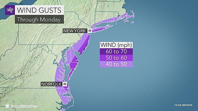
On Labor Day, winds on the coast could gust up to 40 mph but he said winds that were initially expected to top 50 mph are not expected anymore. Some power outages are possible on Labor Day, Simmons said.
Find out what's happening in Darienfor free with the latest updates from Patch.
And we’re just not going to see a lot of rain from Hermine and Simmons said the best we’ll see is some “hit or miss showers.”
NBC Connecticut Meteorologist Ryan Hanrahan in a Sunday morning update on his Facebook page said, “Good news continues with Hermine as it tracks farther out to sea. The weather today actually looks pretty nice in many areas! Some wind and some rain possible for Monday but at this point nothing serious is anticipated locally.”
While Simmons and Hanrahan both agree that the impacts of Hermine are now expected to be less in Connecticut now, the National Weather Service still has a Tropical Storm Warning in effect for the immediate coastal communities in the state.
The warning is still in effect mainly because of wind gusts that could hit 45 mph, the weather service states. However, on Friday the weather service was saying some gusts could hit 70 mph and that has been dropped significantly.
Storm surge is still a concern, the weather service states. Rain will be limited and up to an inch of rain could fall in southeastern Connecticut, which will be closest to Hermine, the weather service states.
Here is the updated forecast via the National Weather Service for Connecticut on Sunday, Labor Day:
Southern Connecticut:
Sunday: Partly sunny and temps between 75-78 degrees. Winds gusting 17-22 mph and up to 28-33 mph later in the day.
Sunday night: Only a 20 percent chance of rain after 1 a.m. and winds around 25 mph with gusts up to 40 mph on the immediate coast. Interior sections will see wind gusts limited to around 30 mph.
Labor Day: 40 percent chance of rain, cloudy skies and temps near 75. Winds gusting up to 44 mph at time on the coast, but winds are only forecast to be 18 mph inland.
Monday night: 30 percent chance of rain and winds around 21-26 mph on the coast and between 12-17 mph inland.
Hartford and Tolland counties:
Sunday: Mostly sunny and a high near 75. A slight wind.
Sunday night: Chance of showers after 1 a.m. and temps down to around 60. Winds around 11-13 mph with occasional gusts to 24 mph.
Labor Day: Showers and a thunderstorm possible during the day, mostly cloudy with a high near 70. Winds may gust up to 28 mph at times. Up to a quarter of an inch of rain is possible.
Monday night: A chance of showers, but mostly cloudy. Winds could gust up to 22 mph.
Photo credit: Accuweather.com
Get more local news delivered straight to your inbox. Sign up for free Patch newsletters and alerts.


