Weather
Should Connecticut Be Worried About Hurricane Jose?
Harvey and Irma have inflicted devastating damage on parts of the country. And here comes Jose. Will it trek up the East Coast?

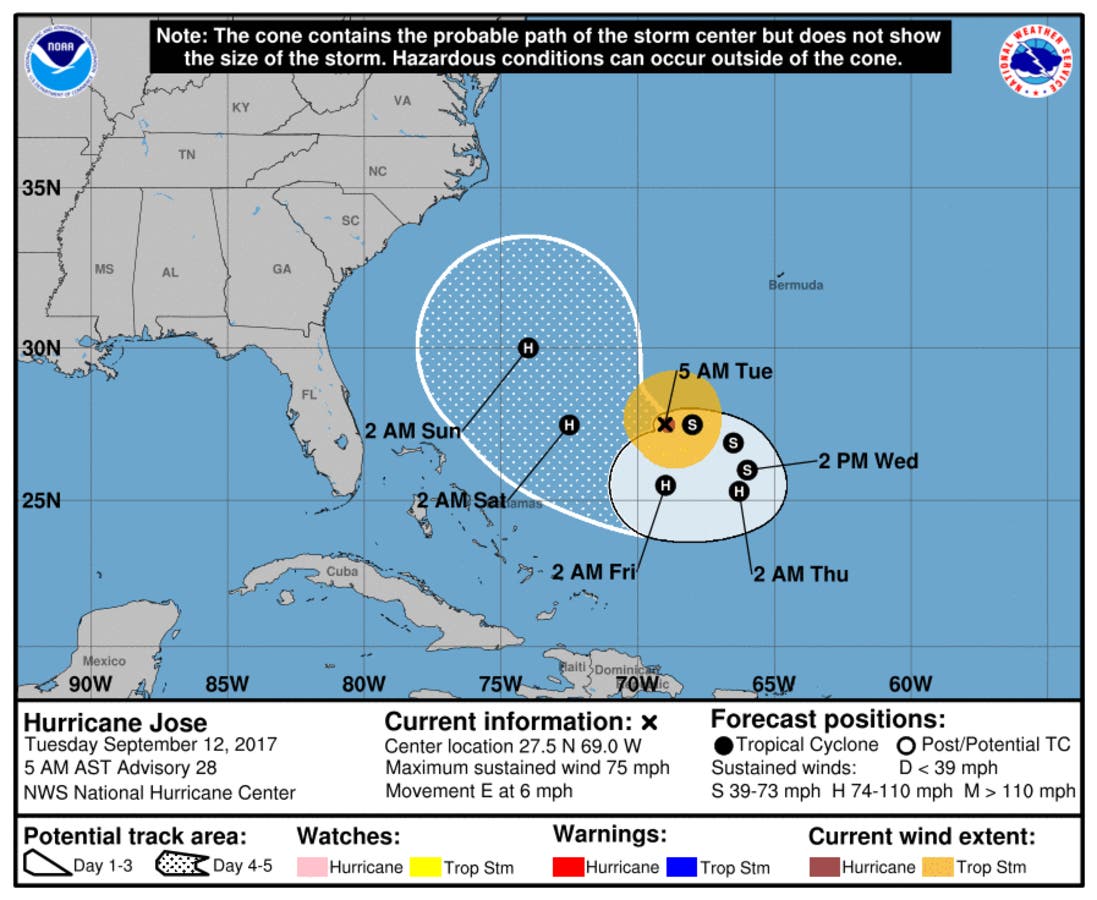
With the Southeast surveying the damage from Hurricane Irma, eyes now turn toward Hurricane Jose, currently Category 1 storm as of Tuesday morning with sustained winds of 75 mph. Jose was located a few hundred miles northeast of Turks and Caicos early Tuesday.
Should Connecticut residents be worried about Jose? No. Not right now, at least. There are a few forecast models that have Jose making its way up the East Coast next week and approaching the region (most models have it going out to sea), but there's a reason why the National Hurricane Center doesn't forecast a hurricane's path beyond five days out. There's way too much uncertainty to accurately predict where a hurricane is headed 7-10 days down the road. (Find Your Patch and more news of the day, including our most-read stories.)
NBC Connecticut Meteorologist Ryan Hanrahan said late Monday on social media, "We'll be watching Hurricane Jose for the next few days. Nothing to worry about now but anytime a hurricane drifts close to the Bahamas it always has my eye." In a blog post, Hanrahan adds, "A few of our computer models have it making landfall in New Jersey, others have it scraping the New England coast, and many models take the storm completely out to sea."
Find out what's happening in Darienfor free with the latest updates from Patch.
Will be watching #Jose for at least a week! #wtnhweather pic.twitter.com/QZJrgcjO3K
— Gil Simmons (@gilsimmons) September 12, 2017
That all said, we are in the heart of the hurricane season. Two hurricanes have just devastated parts of the country. So Connecticut should certainly be prepared for a hurricane if one happens to come our way.
Find out what's happening in Darienfor free with the latest updates from Patch.
Hurricane Jose's complicated path has it performing a loop south of Bermuda early this week.
The potential for a dangerous storm affecting the Bahamas late this week and/or the United State early next week is there, Jeff Masters, the meteorology director at the private forecasting service Weather Underground, says.
But, he cautions, "Until Jose is farther along on its loop, the models are likely to have large errors, and we should not take too much comfort (or indulge in too much angst) over a particular set of model runs."
Hurricane Irma hit Florida with 130 mph winds Sunday, flooding streets, cutting power to millions of homes and leaving at least three people dead. By Monday it had been downgraded to a tropical storm and appeared headed toward Atlanta.
The full Connecticut forecast:
Today: Mostly sunny, with a high near 81. Calm wind becoming southwest 5 to 8 mph in the afternoon.
Tonight: Partly cloudy, with a low around 55. Light west wind.
Wednesday: Isolated showers after noon. Mostly sunny, with a high near 81. Calm wind becoming south 5 to 7 mph in the afternoon. Chance of precipitation is 20%.
Wednesday Night: A 20 percent chance of showers and thunderstorms. Mostly cloudy, with a low around 64. South wind 3 to 7 mph.
Thursday: A 30 percent chance of showers and thunderstorms, mainly after 10am. Partly sunny, with a high near 82. Southwest wind 3 to 7 mph.
Thursday Night: A chance of showers and thunderstorms before 11pm, then a chance of showers between 11pm and 1am, then a chance of showers and thunderstorms after 1am. Mostly cloudy, with a low around 64. Chance of precipitation is 40%.
Friday: Showers and thunderstorms likely, mainly before 3pm. Mostly cloudy, with a high near 78. Chance of precipitation is 60%.
Friday Night: A chance of showers and thunderstorms. Mostly cloudy, with a low around 63. Chance of precipitation is 40%.
Saturday: Mostly sunny, with a high near 79.
Saturday Night: Partly cloudy, with a low around 61.
Sunday: Mostly sunny, with a high near 79.
Ryan Bonner and Adam Nichols contributed to this report.
Get more local news delivered straight to your inbox. Sign up for free Patch newsletters and alerts.


